1891 Railway Publishing Company City Plan or Map of Brooklyn, New York
CityBrooklyn-railwaypublishing-1891$850.00


Title
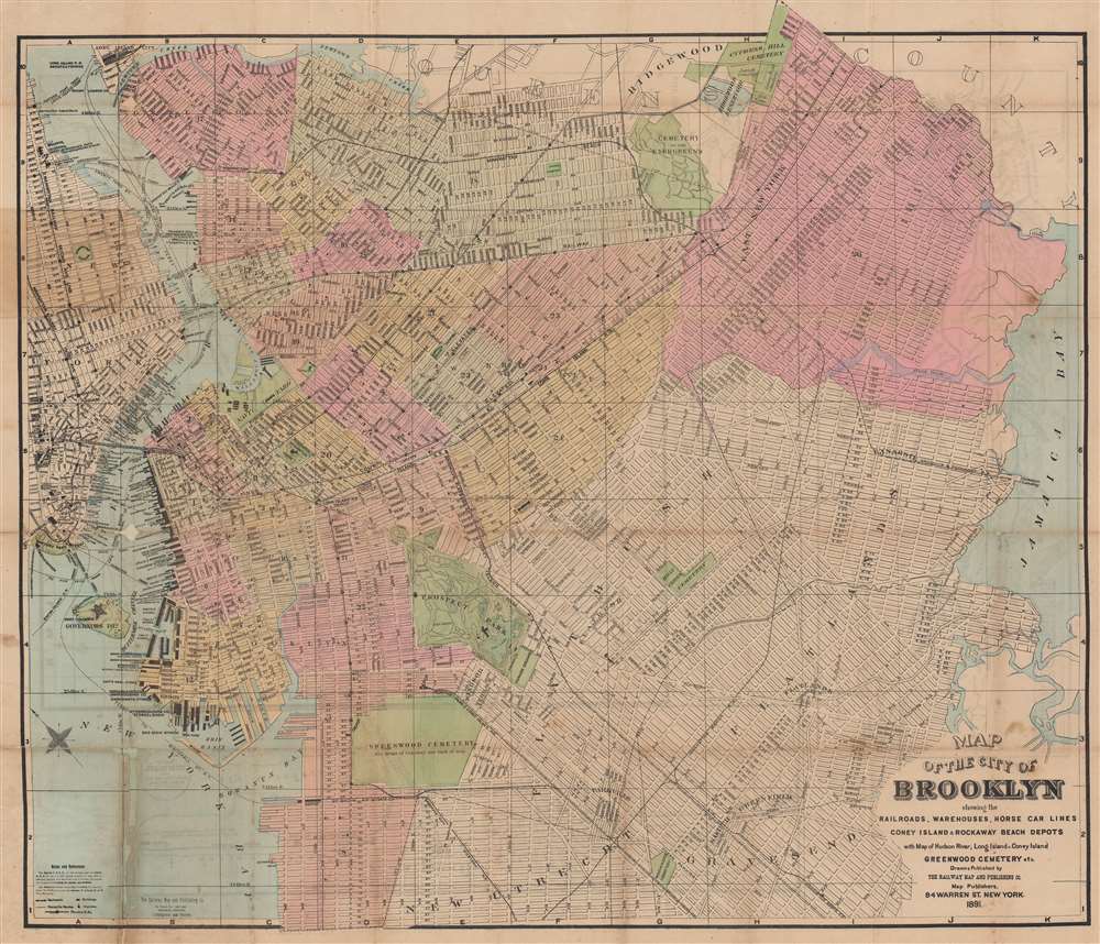
Map of the City of Brooklyn showing the railroads, warehouses, horse car lines, Coney Island and Rockaway Beach Depots.
1891 (dated) 23.75 x 27.25 in (60.325 x 69.215 cm) 1 : 23000
1891 (dated) 23.75 x 27.25 in (60.325 x 69.215 cm) 1 : 23000
Description
This is an 1891 Railway Map and Publishing Company city map of Brooklyn, New York. Published only a few years before consolidation, Brooklyn appears with rich detail throughout, including labeled streets, elevated railways, and the Long Island Railroad.
A Closer Look
The Prospect Park and Coney Island Railroad, South Brooklyn Railroad and Terminal Company, and the Brooklyn, Bath, and Westend Railroad are illustrated. Prospect Park is illustrated in detail as well, with paths throughout. Greenwood Cemetery is shaded green, and a detailed plan of the cemetery is included on the verso. Greenpoint, Williamsburg, South Brooklyn, Flatlands, and East New York are labeled. Piers along the East River are identified by owner, which include steamship companies, mail lines, stores, grain elevators, and other businesses. Ferry routes across the East River appear as dashed lines and are identified.Publication History and Census
This map was created and published by the Railway Map and Publishing Company in 1891. This is the only known example of the 1891 edition. In the OCLC, we note two examples of an earlier map by S. D. L. Taunton bearing the same title. This likely represents an earlier edition of the present map, as Taunton worked for the Railway Map and Publishing Company. However, Taunton absconded from New York in 1885 with numerous debts along with funds collected on behalf of the Railway Map and Publishing Company. Ironically, two of the maps on the verso (the plan of Greenwood Cemetery and the map of Coney Island) both bear Taunton copyrights.Cartographer
S. D. L. Taunton (c. 1848 - c. 1890) was a British civil engineer and mapmaker active in New York City in the 1870s and 1880s. Born in the West Indies, Taunton appears in New York City in the late 1870s as the copyright owner of several maps, either under the name S.D.L. Taunton and Company or simply S.D.L. Taunton, New York. Taunton also worked as the superintendent of the Railway Map and Publishing Company based in New York City. Taunton's other appearance in the historical record (other than through map copyrights) is two references to him absconding from New York City after having passed a series of bad checks and with money from the Railroad Map and Publishing Company. The first notice was published in the New York Times on February 28, 1885, and recounts Taunton's circuitous use of bad checks to pay off successive debts and Taunton stealing money from Methodist Reverend A. H. Goodenough. Goodenough gave Taunton $75 to pay a printer (one of Taunton's friends) to print a newspaper for his church. The printer, William Pagan, was never paid. The second instance is the Railway Map and Publishing Company suing a client in City Court in April 1885 for money they never received that Taunton supposedly collected. We have been unable to find any other historical evidence of Taunton's life before the late 1870s in New York or after he fled the city in 1885. More by this mapmaker...
Condition
Average. Wear along original fold lines. Areas infill in lower left corner and at several fold intersections not effecting areas of the city.