1939 Mountcastle City Plan or Map of Cleveland, Ohio
Cleveland-mountcastle-1939$1,000.00

Title
Cleveland and Environs.
1939 (undated) 27.75 x 41.75 in (70.485 x 106.045 cm) 1 : 36200
1939 (undated) 27.75 x 41.75 in (70.485 x 106.045 cm) 1 : 36200
Description
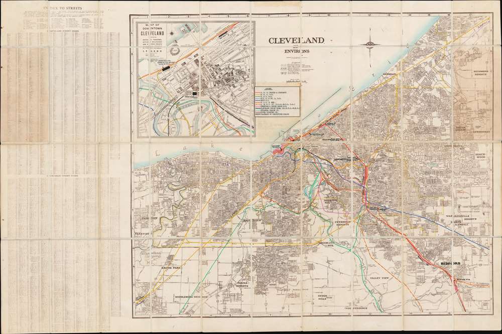
This is a c. 1939 Mountcastle Map Company city plan or map of Cleveland, Ohio and its environs featuring manuscript notations highlighting railroad lines in the area and freight and passenger stations. The map depicts the region from Parkview and the Cleveland airport to Warrensville Heights and from Lake Erie to Independence and Middleburg Heights. Highly detailed, myriad streets throughout the region are illustrated and labeled, with numerous suburbs identified, including Newburgh Heights, Lakewood, Brooklyn Heights, and Beachwood. State and national highways are also identified. An inset map in the upper left quadrant details downtown Cleveland illustrating the municipal stadium (now known as FirstEnergy Stadium and the home of the Cleveland Browns), Public Square, and several hotels, banks, and theaters. The manuscript railroad notations are also present in the inset, tracing the routes of the Pennsylvania Railroad, the New York Central Railroad, the Wheeling and Lake Erie Railway, the Baltimore and Ohio Railroad, and others. Two street indexes, a Cleveland street index and a suburban street index, are situated to the left of the map and list in alphabetical order hundreds of streets along with their grid location on the map.
Manuscript Railroad Lines
Numerous rail lines throughout the region are highlighted in manuscript. Different colors are used to differentiate between the lines, some of which were printed on the original commercial map along with others that appear only in manuscript, such as the River Terminal Railway and the Cuyahoga Valley Railway. A legend, situated above the central map to the right of the inset map, provides the viewer with the names of the various railroads highlighted and which color is used for each one. The Pennsylvania Railroad, the New York Central Railroad, the New York Central and St. Louis Railroad, and the Baltimore and Ohio Railroad are among those illustrated.Union Terminal
Perhaps the most intriguing part of these manuscript notations is the inclusion of the passenger and freight stations within the city and its suburbs, all of which are illustrated and labeled in black. Union Terminal, marked on both the large central map and the inset map of downtown Cleveland, had opened in 1930 and pulled away from the Union Passenger Station along Lake Erie nearly all the passenger traffic through Cleveland. Even though this new facility was larger and much more commercial, it presented one major obstacle: since it was in the center of town trains were not allowed to proceed to the station under steam power. They were forced to change locomotives at a rail yard in the suburbs to proceed to Union Terminal. It also forced trains off the faster route along Lake Erie, costing them time. The facility struggled on as a train station until 1977, when the Conrail commuter service stopped serving the station.Publication History and Census
This map is most likely one of a kind. The base map was created and published by the Mountcastle Map Company c. 1939 and we have been unable to locate any other known examples of it. To add to this map's rarity, this example was repurposed by the Pennsylvania Railroad to illustrate the region's rail routes, making it a unique find.Cartographer
The Mountcastle Map Company (c. 1931 - 1972) was a map publishing firm based in Cleveland, Ohio active during the mid-20th century. More by this mapmaker...
Condition
Very good. Dissected and mounted on linen in 40 panels. Light wear along original folds. Blank on verso.