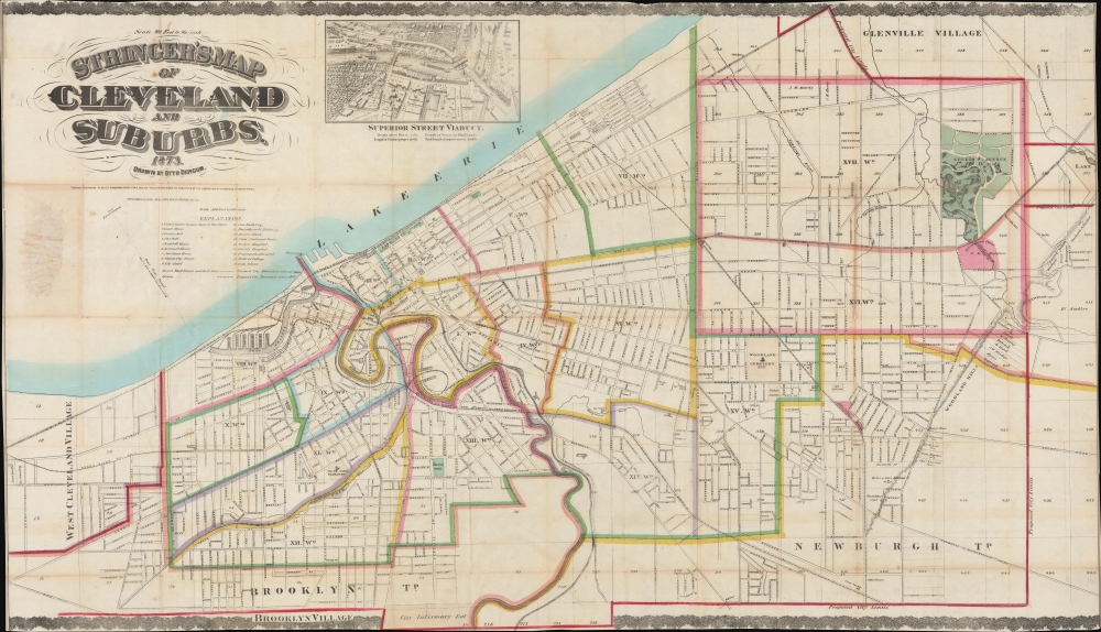
1873 Stringer / Dercum Map of Cleveland, Ohio
Cleveland-stringer-1873$2,800.00


Title
Stringer's Map of Cleveland and Suburbs.
1873 (dated) 31 x 54 in (78.74 x 137.16 cm) 1 : 9600
1873 (dated) 31 x 54 in (78.74 x 137.16 cm) 1 : 9600
Description
This is an impressive 1873 William Stringer and Otto Dercum large-scale map of Cleveland, Ohio. The map was drawn to illustrate the Super Street Viaduct, a transformative infrastructure project that prompted a wave of urban expansion in the late 19th century.
The map's raison d'être is the ongoing construction of the Superior Street Viaduct, depicted in a view at top center. The Viaduct was a major ongoing infrastructure project that promised to transform Cleveland by connecting the eastern parts of the city to the urban center.
A Closer Look
Centered loosely on the Cuyahoga River, coverage embraces metro Cleveland from West Cleveland Village to (roughly) modern-day Euclid-Green, and from Lake Erie to Brooklyn Village. The map is divided according to city wards, with most streets named and railroad connections clearly marked.The map's raison d'être is the ongoing construction of the Superior Street Viaduct, depicted in a view at top center. The Viaduct was a major ongoing infrastructure project that promised to transform Cleveland by connecting the eastern parts of the city to the urban center.
Superior Street Viaduct
The Superior Street Viaduct was a major 19th-century infrastructure project in Cleveland, Ohio intended to link the east and west sides of the city. Constructed between 1875 and 1878, the grandiose Viaduct was Cleveland's first high-level bridge. It was built of Berea sandstone with massive stone arches supporting the superstructure. At the time, Cleveland was rapidly industrializing, and the Viaduct was seen as essential for improving transportation, commerce, and urban expansion. A swinging center span - depicted here - was included to allow ships to pass, reflecting the city's reliance on Great Lakes shipping. For decades, the Viaduct served as a major thoroughfare, but as Cleveland grew, newer bridges eventually rendered it obsolete. Portions of the structure were demolished in the 1920s, though some remnants, including the stone arches, still exist.Publication History and Census
This map was drafted by Otto Dercum and published in 1873 by William Stringer. It was printed in New York by Ferdinand Mayer. We see just three examples in OCLC: Cleveland Public Library, the British Library, and the William Clements Library. Extremely rare on the market.CartographerS
Otto Dercum (March 18, 1839 - August 10, 1927) was a German-American civil engineer, draftsman, and printer active in Cleveland, Ohio in the second half of the 19th century. Dercum was born in Pirmasenz, Germany in 1839. He emigrated to the United States in April of 1865, settling in Cleveland, Ohio, where he was naturalized in October 1871. In the 1890s he worked for the Cleveland Municipal Council as a draftsman. He was a member of the Civil Engineers Club of Cleveland. More by this mapmaker...
Ferdinand Mayer (October 19, 1817 - November 14, 1879) was a prosperous lithographer based in New York during the latter part of the 19th century. Mayer was born in Württemberg, Germany, but emigrated to the United States following the 1848 March Revolutions that swept through the German Confederation - maybe as late as 1854. Initially, Mayer was associated with various partners, including Prang, Nagel, and Korff - also German immigrants. By 1855, he established himself at 96 Fulton Street and, within a few years, expanded to the neighboring property at 98 Fulton Street. Meyer produced an enormous corpus of varied work, including music sheets, bank notes, broadsides, maps, and views. His career was probably jumpstarted through an early partnership with the important cartographer Henry Walling, many of whose maps and atlases bear the 'Ferd. Mayer' imprint. His most important publication is most likely Egbert L. Vielé's 1865 Topographical Map of the City of New York, one of the most important and influential maps of New York City ever published. The Mayer imprint appears on documents as, variously, 'Ferd. Meyer', 'F. Mayer', and 'Mayer and Sons'. Learn More...
William Stringer (fl. c. 1870 - 1875) was an editor and publisher based in Cleveland, Ohio. Learn More...
Condition
Very good. Old onionskin paper exhibits wear on original fold lines. Archival verso reinstatement at most fold intersections. Stable. Edges trimmed by publisher to neatline - as in all examples.
References
OCLC 166640612, 36516239.