This item has been sold, but you can get on the Waitlist to be notified if another example becomes available, or purchase a digital scan.
1581 Bunting Map of the World as a Clover Leaf
CloverleafWorld-bunting-1581$3,750.00

Title
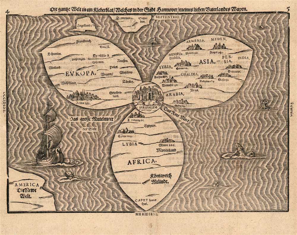
Die ganze Welt in ein Kleberblat, Welches in der Stadt Hannover, meines lieben Vaterlandes Wapen.
1581 (undated) 10.75 x 15 in (27.305 x 38.1 cm)
1581 (undated) 10.75 x 15 in (27.305 x 38.1 cm)
Description
This is Heinrich Bünting's 1581 map of the world, dramatically presented as a clover leaf, in an early first block example. No other early map utilized this configuration. This beautiful woodcut appeared in Bünting's Itinerarium Sacrae, the first and for many years the only complete work of biblical geography. As such, this map's central positioning of Jerusalem and the Red Sea - recalling medieval mappamundae - is appropriate. The map's puzzling trefoil shape, with Asia, Africa and Europe each given a leaf, invokes Ptolemy's three parts of the world, as well as the medieval T-O map's tripartite form. The map's title, however, gives insight to Bünting's motivation for producing so singular an image: Die ganze Welt in ein Kleberblat, welches in der Stadt Hannover, Meines lieben Vaterlandes Wapen translates to:
The Whole World in a Cloverleaf, Which is the Arms of my Dear Fatherland, Hanover.Bünting is using the centerpiece map of his book to tip his hat to his home town.
Publication History and Census
This map has long been a justifiable favorite of collectors, and has appeared on the market with regularity, though attractive examples are becoming harder to source. Perhaps ten original examples of the separate map appear in OCLC. The Itinerarium totes Sacrae Scripturae appears in many editions in institutional collections. This is an example of the first block, appearing in the 1581-1582 Helmstadt editions of the Itinerarium: most examples on the market were printed from later, re-cut blocks and printed in Magdeburg.Cartographer
Heinrich Bünting (1545 – 1606) was a Protestant pastor and theologian. He was born in Hanover, and studied theologian Witemberg. He is best known for his book of woodcut maps titled Itinerarium Sacrae Scripturae (Travel book through Holy Scripture) first published in 1581. It was the first complete summary of biblical geography available. More by this mapmaker...
Source
Bünting, Heinrich Itinerarium Sacrae Scripturae, Helmstadt 1581
Condition
Excellent condition. Complete margins, no mends or stains. Reinforced at folds, no loss or mends.
References
OCLC: 558017326 cf. Shirley 142; Nebenzahl, Maps of the Holy Land, pp. 88-9.