This item has been sold, but you can get on the Waitlist to be notified if another example becomes available, or purchase a digital scan.
1585 Bunting Map of the World as a Clover Leaf
CloverleafWorld-bunting-1585-2$4,250.00

Title
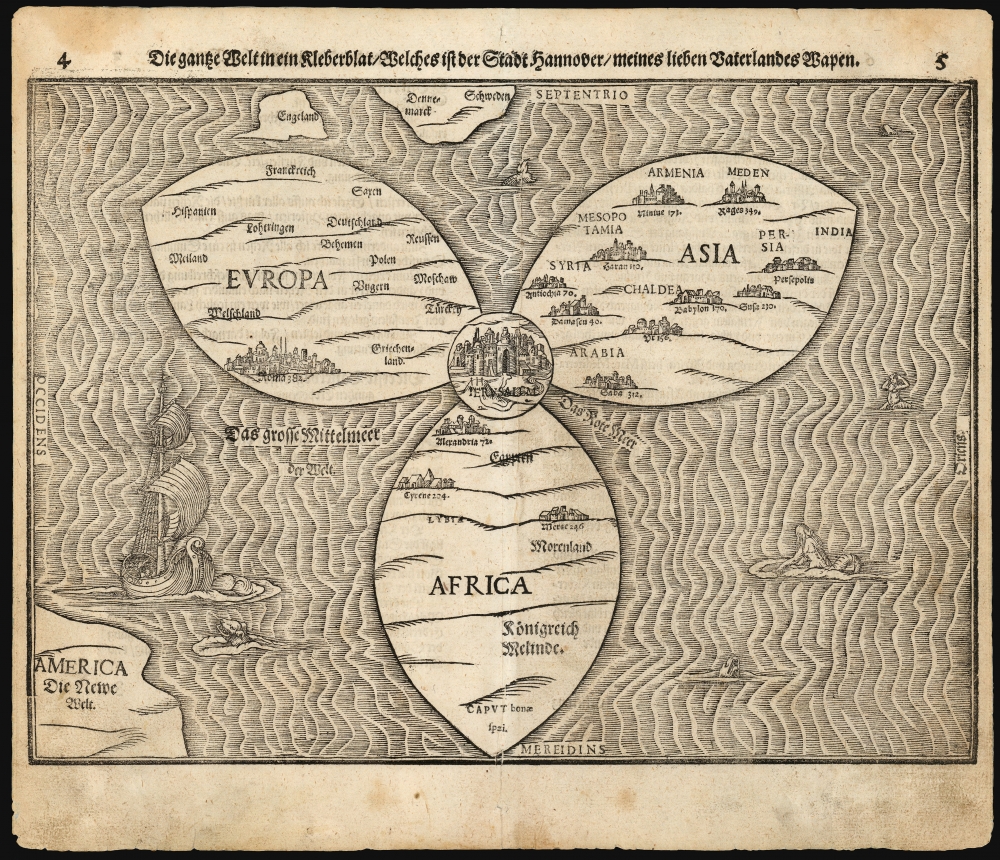
Die gantze Welt in ein Kleberblat, Welches ist der Stadt hannover / meines lieben Vaterlandes Wapen.
1585 (undated) 10.5 x 14.25 in (26.67 x 36.195 cm)
1585 (undated) 10.5 x 14.25 in (26.67 x 36.195 cm)
Description
This is Heinrich Bünting's 1585 / 1597 iconic map of the world, dramatically presented as a clover leaf. This beautiful woodcut appeared in Bünting's Itinerarium Sacrae, the first and for many years the only complete work of biblical geography.
As a biblical geography, the central positioning of Jerusalem and the Red Sea - recalling medieval mappamundae - is also appropriate. The trefoil shape, with Asia, Africa, and Europe each given a leaf, invoked the mysteries of the Holy Trinity. It moreover refers to Ptolemy's three-part world, as well as the medieval T-O map's tripartite form. Note however, America ‘Die Newe Welt’, appearing in the lower left, drawing the three-part world view into conflict with the Ptolemaic system. Curiously, England and Scandinavia also lie outside of the primary circles:.
Why a Clover Leaf?
The map's title gives insight to Bünting's motivation for producing so singular an image: Die gantze Welt in ein Kleeberblat, welches ist der Stadt Hannover, Meines lieben Vaterlandes Wapen (‘The Whole World in a Cloverleaf, Which is the Arms of my Dear Fatherland, Hanover). As the clover appears prominent on the armorial crest of Hannover, with this map Bünting is tipping his hat to his home town and patrons.As a biblical geography, the central positioning of Jerusalem and the Red Sea - recalling medieval mappamundae - is also appropriate. The trefoil shape, with Asia, Africa, and Europe each given a leaf, invoked the mysteries of the Holy Trinity. It moreover refers to Ptolemy's three-part world, as well as the medieval T-O map's tripartite form. Note however, America ‘Die Newe Welt’, appearing in the lower left, drawing the three-part world view into conflict with the Ptolemaic system. Curiously, England and Scandinavia also lie outside of the primary circles:.
Publication History and Census
This map first appeared in Bünting's Itinerarium in 1581, and appeared in the work's many editions for the rest of the century. There are at least three blocks: the first block was only been used in the 1581 and 1582 Helmstadt editions. A second was cut, probably in 1585, for the Magdeburg editions (present example). It stayed in use from then, with typographical variations, until 1598. The present example corresponds typographically to the 1597 Magdeburg edition of the Itinerarium. The sole 1585 Leipzig edition used its own blocks. The map has long been a justifiable favorite of collectors and has a long record of appearances at auction and in dealers' catalogs, though attractive examples are becoming harder to source. Perhaps ten examples of the separate map appear in OCLC. The Itinerarium Sacrae Scripturae appears in many editions in institutional collections.Cartographer
Heinrich Bünting (1545 – 1606) was a Protestant pastor and theologian. He was born in Hanover, and studied theologian Witemberg. He is best known for his book of woodcut maps titled Itinerarium Sacrae Scripturae (Travel book through Holy Scripture) first published in 1581. It was the first complete summary of biblical geography available. More by this mapmaker...
Source
Bünting, Heinrich, Itinerarium Sacrae Scripturae, (Magdeburg: Kirchner) 1597.
Condition
Very good. Centerfold mend at bottom, faint scuffing, else excellent.
References
OCLC: 558017326 (also see 634881449) cf. Shirley 142; Nebenzahl, Maps of the Holy Land, pp. 88-9.