This item has been sold, but you can get on the Waitlist to be notified if another example becomes available, or purchase a digital scan.
1892 Flores Map of Coahuila and Chihuahua, Mexico-Texas Border
CoahuilaChihuahua-flores-1892$1,250.00

Title
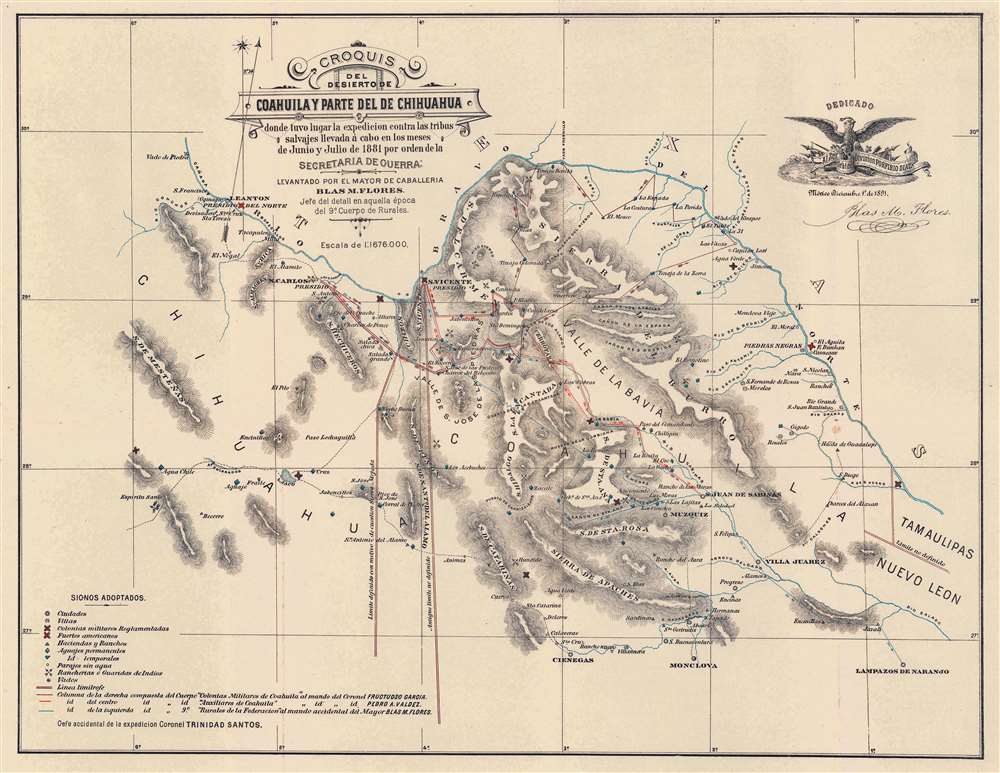
Croquis del Desierto de Coahuila y Parte del de Chihuahua donde tuvo lugar la expedicion contra las tribus salvajes llevada á cabo en los meses de Junio y Julio de 1881 por orden de la Secretaria de Guerra.
1892 (dated) 15.75 x 20.25 in (40.005 x 51.435 cm) 1 : 1676000
1892 (dated) 15.75 x 20.25 in (40.005 x 51.435 cm) 1 : 1676000
Description
This is a very rare 1892 Major Blas María Flores map of the Mexico-Texas border illustrating a little-known chapter of the Apache Wars (1849 - 1887). It describes an 1881 Mexican Army campaign against the Lipan Apache led by Major Blas María Flores. This was the last major action of the Mexican Federal Government against the Apache. The map was further intended to detail population centers, routes, and favored Apache haunts to support Flores' argument for the strategic placement of military colonies to protect settlement and investment. Coverage encompasses the northernmost parts of Coahuila and Chihuahua, Mexico, and the adjacent Texas border lands. Purple, red, and blue lines trace routes followed by Mexican army columns. Lipan ranches and other settlements, along with haciendas and rancherias owned by Mexicans are noted. Both Mexican and American forts are illustrated, along with water sources.
Flores and the 1881 Expedition
The 1881 Expedition was a series of raids on the Apache tribes along the Mexico-Texas border ordered by Mexican President Porfirio Diaz and orchestrated by Major Blas María Flores (1853 - March 4, 1903). Diaz had long-term plans to develop and colonize the Coahuila - of which the Apache were a major impediment. On trumped-up but real charges of rebellion against Mexico and hacienda owners, Diaz commanded an all-out campaign of eradication against the Lipan that include burning villages and wholesale slaughter. Action spilled onto both sides of the border, as the United States was engaged in a similar campaign against Geronimo and his Apache coalition in Texas and New Mexico. The campaigns can be folded into the greater theater of the Apache Wars (1849 - 1887), wherein Mexico and the United States collaborated to suppress the Apache on both sides of the border.Publication History and Census
This map was created by Blas María Flores to accompany his 1892 report, Exploración Practicada en el Desierto de Coahuila y Chihuahua. The pamphlet is cataloged in OCLC as being part of sixteen institutional collections worldwide, but the separate map does not appear in OCLC. We are aware of only one other example in private hands.Cartographer
Blas María Flores (1853 - March 4, 1903) was a Mexican military commander active in the second half of the 19th century. Flores is best known as the leader of a Mexican campaign against the Apache of Coahuila and Chihuahua in 1880 - 1881. He highest known rank is Major (Mayor). More by this mapmaker...
Source
Flores, B. M., Exploración Practicada en el Desierto de Coahuila y Chihuahua, (Mexico City: Oficina Tipografica de la Secretaria de Fomento) 1892.
Condition
Very good. Verso repair to a fold separation. Closed margin tear professionally repaired on verso.