This item has been sold, but you can get on the Waitlist to be notified if another example becomes available, or purchase a digital scan.
1864 Purdy Nautical Chart / Map of the Coast of China (Hong Kong, Taiwan)
CoastofChina-purdy-1865$4,250.00

Title
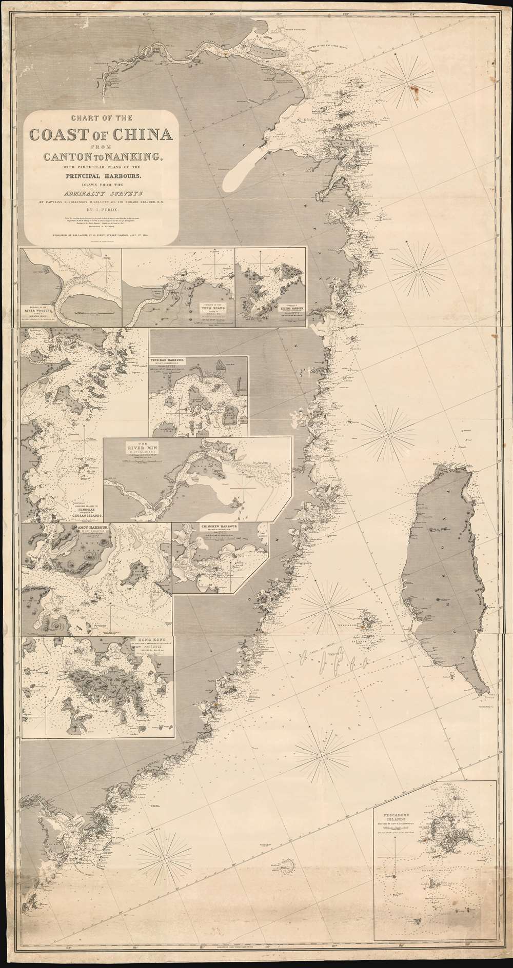
Chart of the Coast of China from Canton to Nanking, with particular plans of the principal Harbors, Drawn from the Admiralty Surveys by Captains R. Collinson, H. Kellett and Sir Edwad Belcher, R. N.
1865 (dated) 73 x 38.5 in (185.42 x 97.79 cm) 1 : 855000
1865 (dated) 73 x 38.5 in (185.42 x 97.79 cm) 1 : 855000
Description
An exceptionally rare and important 1865 nautical chart or maritime map of the coast of China compiled by John Purdy from the surveys of Sir Edward Belcher (Hong Kong), Richard Collinson (China Coast), and Henry Kellett (China Coast) - probably the best general map of the China coast then obtainable. The map's coverage extends from mouth of the Yangtse River (Nanjing and Shanghai) south as far as Hong Kong and Macao, and east to include Taiwan (Formosa). The chart includes nine insets, among them a large representation Collinson's update of Belcher's First Opium War Hong Kong survey of 1841. This map, made after the second opium war, represents the high point of the China Trade when cities like Shanghai and Hong Kong were transforming into global centers of trade and commerce, largely at the expense of an increasing angry and frustrated Chinese populace
Exceedingly rare. There is only a single other known example of the present 1865 chart, held by the National Library of Australia. That example was loaned to the Hong Kong Maritime Museum for their 2015 exhibit Charting The Pearl River Delta. The 1851 chart is held in a single surviving example by the British Library.
China in the 1860s
Following their humiliating defeat during the Second Opium War (1856 - 1860), the Qing entered a period of sharp decline. The humiliation of the Qing army by a relatively small Anglo-French military force (outnumbered at least 10 to 1) coupled with the flight (and subsequent death) of the Xianfeng Emperor, and the burning of the Summer Palaces, was a shocking blow to the Chinese populace. The Self-Strengthening Movement or Western Affairs Movement (自强运动), a series of social and economic reforms intended to modernize China followed, among these the adoption of Western firearms, machines, and scientific knowledge. While such efforts focused in European influenced urban centers, the rural interior of China became increasingly unstable. The ongoing Taiping and Nian Rebellions, bent on overthrowing the Qing, increased their power, laying siege unsuccessfully to Shanghai (1860) and Beijing (1865). At the same time, the international treaty ports, established during the Opium Wars, led to increase trade activity and western influence, for better or worse, throughout coastal China. Foreign excesses and intrusions would, by 1900, lead to the bloody Boxer Rebellion.Blueback Charts
Blueback nautical charts began appearing in London in the late 18th century. Bluebacks, as they came to be called, were privately published large format nautical charts known for their distinctive blue paper backing. The backing, a commonly available blue manila paper traditionally used by publishers to warp unbound pamphlets, was adopted as a practical way to reinforce the low-quality paper used by private chart publishers in an effort to cut costs. The earliest known blueback charts include a 1760 chart issued by Mount and Page, and a 1787 chart issued by Robert Sayer. The tradition took off in the early 19th century, when British publishers like John Hamilton Moore, Robert Blachford, James Imray, William Heather, John William Norie, Charles Wilson, David Steel, R. H. Laurie, and John Hobbs, among others, rose to dominate the chart trade. Bluebacks became so popular that the convention was embraced by chartmakers outside of England, including Americans Edmund March Blunt and George Eldridge, as well as Scandinavian, French, German, Russian, and Spanish chartmakers. Blueback charts remained popular until the late 19th century, when government subsidized organizations like the British Admiralty Hydrographic Office and the United States Coast Survey, began issuing their own superior charts on high quality paper that did not require reinforcement.Publication History and Census
This map was first published in 1851, following the Collinson and Kellett Survey of the coast of China (1842 - 1846) and Belcher's work in Hong Kong (1841). That edition, of which only one examples is known (British Library BLL01004820286) was signed by John Purdy, who probably compiled the chart. The present example was resurrected and updated with the 'I. Purdy' imprint by Purdy's grand-nephew Isaac Purdy in 1865. The engraving is the work of Alexander George Findlay, who, dispute the R. H. Laurie imprint, was probably also the 1865 publisher, as he had, by this time, taken over the deceased Laurie's business.Exceedingly rare. There is only a single other known example of the present 1865 chart, held by the National Library of Australia. That example was loaned to the Hong Kong Maritime Museum for their 2015 exhibit Charting The Pearl River Delta. The 1851 chart is held in a single surviving example by the British Library.
CartographerS
Isaac Purdy (May 22, 1804 - September 1852) was a British hydrographer and engraver active in the second quarter of the 19th century. Purdy was born in Middlesex, England, the son of a gunsmith and the nephew of the cartographer and hydrographer John Purdy. He worked for the firm of Richard Holmes Laurie as an engraver and hydrographer before transitioning to the Admiralty sometime in 1851. Several nautical charts from the 1840s and as late as 1851, bear his imprint. He should not be confused with Isaac Purdy 2 (fl. c. 1840 - 1869), a relative and also a hydrographer. More by this mapmaker...
Alexander George Findlay (January 6, 1812 - May 3, 1875) was an English geographer and hydrographer active in London during the middle part of the 19th century. Findlay was born in London to the Findlays of Arbroath, Forfarshire, a family long associated with nautical trades. Findlay's father, Alexander Findlay (apprentice to John Russell) was one of the original fellows of the Royal Geographical Society. The son, Alexander George Findlay, devoted himself to the compilation of geographical and hydrographical works, publishing various nautical works as well as historical atlases. In 1844 he was elected a fellow of the Royal Geographical Society. Most of Findlay's early nautical work was completed in association with the London geographical and print publishing firm of Laurie and Whittle. Following the 1858 death of Richard Holmes Laurie, Findlay took over the business, republishing many updated versions of established charts well into the late 19th century. Learn More...
Richard Collinson (November 7, 1811 – September 13, 1883) was an English naval officer, marine surveyor, and Arctic explorer. He was born in Gateshead, Tyne and Wear, England, then part of Durham. He joined the Royal Navy in 1823, at age twelve, and rose in the ranks, becoming a lieutenant in 1835, commander in 1841, and captain in 1842. Collinson was a highly capable captain. He participated with distinction in the First Opium War (1839 - 1842). After the war, along with Commander Henry Kellett, he completed a series of pioneering surveys of the China coast from the Yangtze River to Hong Kong. These he completed between 1842 and 1846 while serving as commander of the HMS Plover. In 1850, he was sent north in command of the HMS Enterprise to search for survivors of the Sir John Franklin expedition. Although he came quite close, he never found Franklin's lost men and returned to England without success. Nonetheless, he was honored by the Royal Geographical Society for his surveys in the Arctic and proof that it was navigable from the Behring Strait to King William's Land. Collinson was Knighted in 1875, the same year in which he retired from active duty with the rand of Admiral. Collinson died in September of 1883. Learn More...
Sir Edward Belcher (February 27, 1799 – March 18, 1877) was a British naval officer, scientist, explorer, and marine surveyor active in the middle part of the 19th century. Belcher was born in Halifax, Nova Scotia, to a proud seafaring family. He entered the Royal Navy in 1812, at just 13 years of age. Thirteen years later, in 1825, he was assigned as official surveyor to the Frederick William Beechey expedition to the Pacific and the Bering Strait. By 1836 he was in command of his own surveying (and bombing) ship, the H.M.S. Sulphur in western Africa and the Pacific coast of South America. The Sulphur was ordered back to England via the Trans-Pacific Route in 1839. On the way, he was delayed and reassigned to China to take part in the First Opium War (1839 – 1842). During this period, on January 26 of 1841, he landed on Possession Point on the northern shore of Hong Kong Island. During this visit he made the influential first British survey of Hong Kong Harbor. On returning to England he was Knighted for his services and reassigned to the HMS Samarang to complete survey work throughout the East Indies, but most specifically in the Philippines. In 1852 he commanded the last and largest Admiralty expedition in search of the lost Arctic Explorer Sir John Franklin. The expedition had five ships, four of which were lost to the Arctic ice. Like all British naval officers who lose a ship, he was court-martialed on his return to England. Although exonerated, he never received another command. He died in London at the age of 78. Belcher is commemorated in Hong Kong through Belcher's Street, Belcher Bay and The Belcher's in Kennedy Town. His name is also commemorated in the Belcher Islands, in the Canadian Arctic. He is also commemorated with a plaque in the Admiralty Garden. Following his last active service, he was appointed Knight Commander of the Order of the Bath in 1867 and an admiral in 1872. Learn More...
Condition
Very good. Professional restoration. Some margin fill.
References
OCLC 556904475