
This item below is out of stock, but another example (left) is available. To view the available item, click "Details."
Details
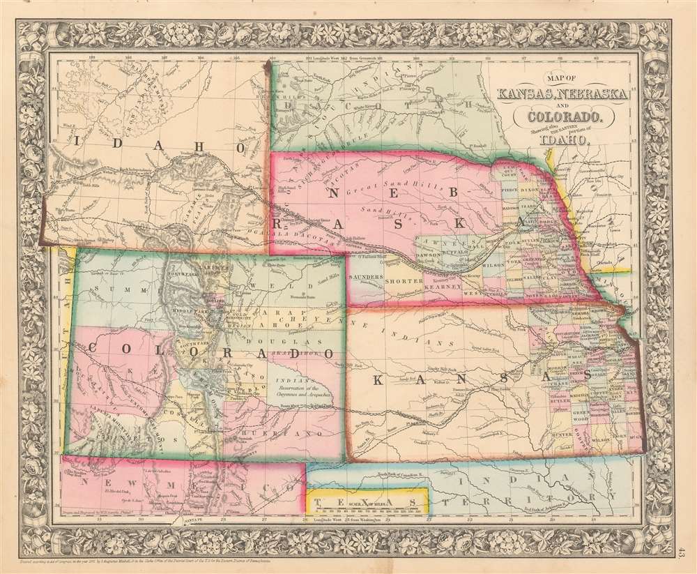
1863 Mitchell Map of Colorado, Kansas, Nebraska and Idaho / Wyoming
$350.00
1863 Mitchell Map of Kansas, Nebraska, Colorado, and Idaho
COKANE-mitchell-1863$175.00

Title
Map of Kansas, Nebraska and Colorado, Showing also the Eastern Portion of Idaho.
1861 (dated) 12.25 x 15 in (31.115 x 38.1 cm) 1 : 4000000
1861 (dated) 12.25 x 15 in (31.115 x 38.1 cm) 1 : 4000000
Description
A very ephemeral and surprisingly scarce 1863 Samuel Augustus Mitchell, Jr. map of Colorado, Nebraska, Kansas, and that part of Idaho Territory which is today Wyoming. The map depicts the region from the Utah-Colorado border to Iowa and Missouri and from the Big Horn Mountains to northern Texas and Santa Fe, New Mexico. This map holds the distinction of being one of the few to include Wyoming as Idaho Territory, which was formed in March 1863. The iteration of Wyoming/Idaho as seen here is exceptionally ephemeral and present only in this edition (1863), with subsequent editions (1864 - 1868) attaching Wyoming to Dakota (See below). Apart from this rare iteration of Idaho Territory / Wyoming, other intriguing aspects of this map include the fact that only about one half of Nebraska and the eastern third of Kansas are illustrated as having been divided into counties, while Colorado only has fifteen counties that vary wildly in relative size. Myriad towns and villages are labeled, along with the Pony Express route and proposed routes for the transcontinental railroad.
The Mapping of Wyoming by Mitchell
This is one of Mitchell's most interesting and an important map, as in many editions, it covers the development of Colorado / Idaho / Wyoming / Dakota from the 1860 creation of Colorado Territory to the 1868 incorporation of Wyoming Territory. This map did not appear in the 1860 first edition of Mitchell's New General Atlas, when this region was still part of Nebraska Territory. Rather, it was introduced in 1861 following the formation of Colorado Territory and the 1859 Colorado Gold Rush. The map went through multiple annual and sometimes semi-annual updates, most of which focused on the Idaho/Wyoming section. Dakota was incorporated as a territory from the northeastern part of Nebraska Territory in 1861 and maps from that period include Wyoming as the 'Southern portion of Dacotah.' After 1863, when Idaho was incorporated as a territory, the map was updated, as seen here, to include Wyoming as the 'Eastern Portion of Idaho.' This edition is exceptionally rare and ephemeral, as in 1864 Montana was organized as a territory out of eastern Idaho Territory, with what is today Wyoming being stripped off of Idaho and re-attached to Dakota Territory, thus subsequent maps reapply the 'Southern portion of Dacotah.' This lasted until the incorporation of Wyoming Territory in 1868.Publication History and Census
This map appeared in the 1863 edition of Mitchell's New General Atlas. For a detailed breakdown of the maps' history, see above. This map was engraved by William Henry Gamble in Philadelphia, first in 1861, then updated annually through 1868, when it was retired and completely new map was issued. Like many American map publishers of this period, though he did update his maps, Mitchell did not update his copyrights, consequently most examples of this map are dated and copyrighted to 1861. The present map features the attractive floral border common to Mitchell atlases between 1860 and 1866.Cartographer
Samuel Augustus Mitchell (March 20, 1792 - December 20, 1868) began his map publishing career in the early 1830s. Mitchell was born in Bristol, Connecticut. He relocated to Philadelphia in 1821. Having worked as a school teacher and a geographical writer, Mitchell was frustrated with the low quality and inaccuracy of school texts of the period. His first maps were an attempt to rectify this problem. In the next 20 years Mitchell would become the most prominent American map publisher of the mid-19th century. Mitchell worked with prominent engravers J. H. Young, H. S. Tanner, and H. N. Burroughs before attaining the full copyright on his maps in 1847. In 1849 Mitchell either partnered with or sold his plates to Thomas, Cowperthwait and Company who continued to publish the Mitchell's Universal Atlas. By about 1856 most of the Mitchell plates and copyrights were acquired by Charles Desilver who continued to publish the maps, many with modified borders and color schemes, until Mitchell's son, Samuel Augustus Mitchell Junior, entered the picture. In 1859, S.A. Mitchell Jr. purchased most of the plates back from Desilver and introduced his own floral motif border. From 1860 on, he published his own editions of the New General Atlas. The younger Mitchell became as prominent as his father, publishing maps and atlases until 1887, when most of the copyrights were again sold and the Mitchell firm closed its doors for the final time. More by this mapmaker...
Source
Mitchell's New General Atlas, containing Maps of the Various Countries of the World, Plans of Cities, Etc., Embraced in Fifty-three Quarto Maps, forming a series of Eighty-Four Map and Plans, together with Valuable Statistical Tables. (1864 Edition)
Mitchell's New General Atlas was published by Samuel Augustus Mitchell, Jr., the son of the prolific cartographer Samuel Augustus Mitchell. Many of the plates are derived from the his father's Mitchell's Universal Atlas, but not directly. The Mitchell's Universal Atlas was initially sold to Thomas, Cowperthwait, and Company in 1849, and again to Charles Deliver in 1856. It was Deliver who introduced the new vibrant color scheme, abandoning the older Mitchell's Universal Atlas green borders and themes for bright reds, blues, and yellows. Samuel Augustus Mitchell, Jr. acquired the Deliver plates in 1859. He added his own floral motif border, but doubled down on the vibrant color scheme, thus introducing to the American public the most vividly colored American atlas of the 19th century. In 1860, he published the first edition of his New General Atlas and, despite a slump in sales during the American Civil War, attained a level of success to rival his father. Mitchell would continue to publish the New General Atlas until 1887, when the firm formally closed.
Condition
Very good. Even overall toning. Blank on verso.
References
Karrow, Robert W., Checklist of Printed Maps of the Middle West to 1900, 1-0176. Phillips (Atlases) 831-16. Wheat, Carl Irving, Mapping of the Transmississippi West, 1540-1861, 1030.