1867 Beers Map of Cold Spring, New York
ColdSpringGarrison-beers-1867$450.00

Title
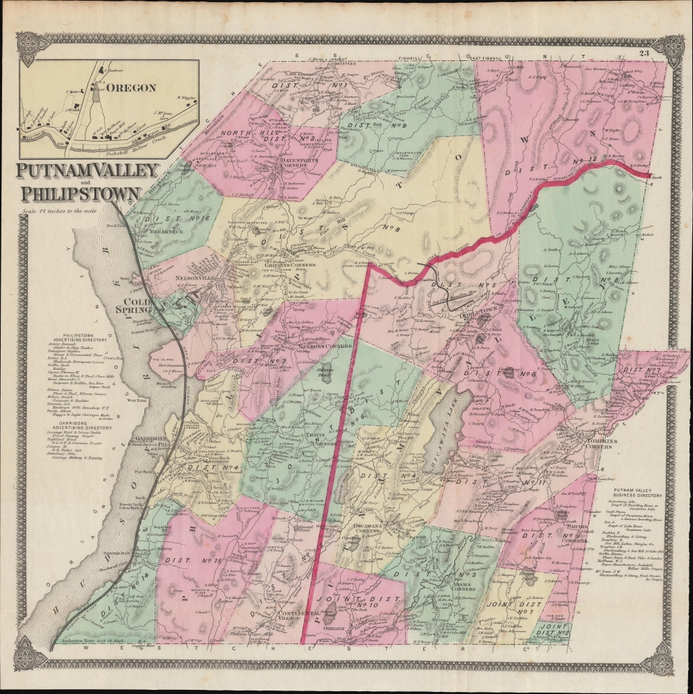
Putnam Valley and Philipstown.
1867 (undated) 19 x 19 in (48.26 x 48.26 cm) 1 : 42240
1867 (undated) 19 x 19 in (48.26 x 48.26 cm) 1 : 42240
Description
This is F. W. Beers' 1867 hand-colored map of the towns of Putnam Valley and Philipstown, along the Hudson River in Putnam County, New York.
Individual buildings are illustrated with their owners noted. Schools, mines, docks, waterways (including Oscawana Lake), and other features are labelled throughout. Numbers along roads signal their distances. Rail lines belonging to the Hudson River Railroad run north-south at left along the river. A small West Point Railroad runs to the West Point Mine towards top-right. An inset at top-left displays the hamlet of Oregon, located at bottom-center on the main map. In the margins, directories list businesses in Putnam Valley, Philipstown, and Garrison.
A Closer Look
Coverage includes the towns of Philipstown and Putnam Valley with their constituent districts, color shaded for easy distinction, along with villages and hamlets, including Cold Spring and Garrison (here as 'Garrisons P.O.') along the Hudson River. The U.S. Military Academy at West Point sits directly across the Hudson from Garrison. Between Cold Spring and Garrison is 'Fort Constitution,' the site of fortifications during the Revolutionary War and the only part of the military academy on the east bank of the Hudson.Individual buildings are illustrated with their owners noted. Schools, mines, docks, waterways (including Oscawana Lake), and other features are labelled throughout. Numbers along roads signal their distances. Rail lines belonging to the Hudson River Railroad run north-south at left along the river. A small West Point Railroad runs to the West Point Mine towards top-right. An inset at top-left displays the hamlet of Oregon, located at bottom-center on the main map. In the margins, directories list businesses in Putnam Valley, Philipstown, and Garrison.
Publication History and Census
This map was prepared by Frederick William Beers and published in 1867 in the Atlas of New York and Vicinity from Actual Surveys. Six printings of this atlas were issued in 1867, which differ considerably from each other (analyzed in Barbara McCorkle's 1990 article 'The Strange Case of F. W. Beers and the Atlas of New York and Vicinity'). The present map appeared in three of these printings (see Rumsey 0063.026, 0064.033, and 4631.026).CartographerS
The Beers family (Fredrick, Silas, James and Daniel) (fl. c. 1850 - 1886), along with Charles and Augustus Warner, were prominent map publishers working from the 1850s to the late 1880s. Often publishing under the Warner & Beers designation, the combined firms produced a series of important state and county atlases and map of much of the northeastern United States. Many of their regional maps are among the most detailed and well laid out maps ever produced of their respective regions. Because Warner & Beers county maps were often detailed down to the individual homes and landowners, they have become highly sought after by general and family historians. In additional to producing maps of surpassing detail, Warner & Beers also maintained an earlier generation's attention to detail and quality while publishing in an era ever increasingly dominated by the low cost printing methods used by the publishing empires of Rand McNally and George Cram. More by this mapmaker...
Frederick William Beers (August 17, 1839 - September 8, 1933) was an American map publisher, cartographer, and surveyor. Beers was born in Maryland, the son of map publisher James Botsford Beers (October 16, 1811 - June 3, 1901), but lived much of his life in New York where he was the chief of the map division and Commissioner of Public Records in Brooklyn. He joined the family business in 1870 and along with his father, published the Farm Line Atlas of the County of Kings and the Atlas of Long Island. He is credited with personally mapping every county in New York State. Frederick worked with his family into the mapmaking trade, including his brother, Charles Henry Beers (November 3, 1813 - March 5, 1892), and nephews Silas Norman Beers (September 3, 1837 - May 12, 1873) and Daniel Glover Beers (October 19, 1841 - February 12, 1913). He retired from the publishing business in 1930, when he was more than 90 years old. He died on September 8, 1933 in Bridgeport, Connecticut. Learn More...
Source
Beers, F. W., Atlas of New York and Vicinity, (New York: Beers, Ellis, Soule) 1867.
Condition
Good. Some toning and creasing along old fold lines.
References
Rumsey 0063.026. Barbara McCorkle, 'The Strange Case of E.W. Beers and the Atlas of New York and Vicinity' (Meridian, 5:39-43).