1897 Garcia y Cubas Map of Colima, Mexico
Colima-garciacubas-1897$450.00

Title
Colima.
1897 (dated) 13.5 x 16.5 in (34.29 x 41.91 cm) 1 : 500000
1897 (dated) 13.5 x 16.5 in (34.29 x 41.91 cm) 1 : 500000
Description
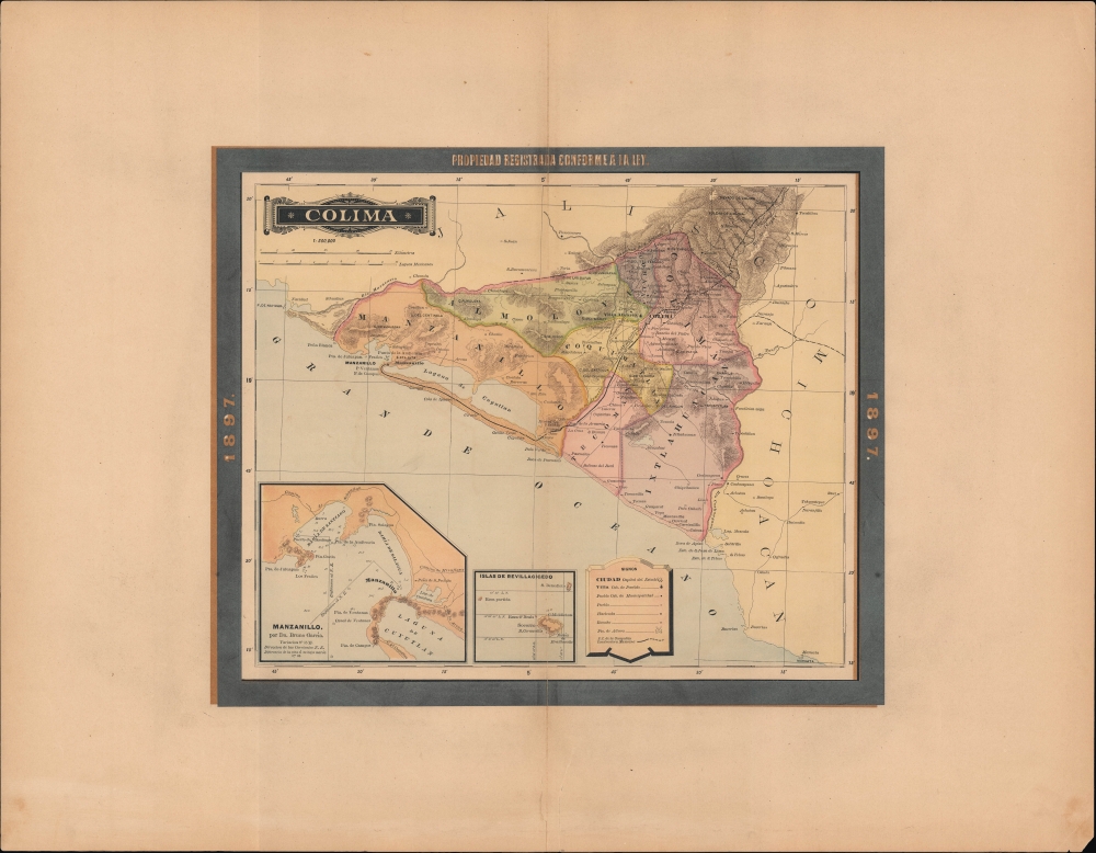
A map of the Mexican state of Colima, Mexico, published in 1897 for the Atlas Geográfico de los Estados Unidos Mexicanos.
A Closer Look
The state of Colima on Mexico's central Pacific coast is displayed, noting cities and towns, railways (existing and under construction), haciendas, ranchos, and ports. Districts are color-shaded for easy distinction. Portions of the neighboring states of Jalisco and Michoacán are also depicted. At bottom-left are two insets, of Manzanillo and the Revillagigedo Islands, volcanic islands nearly 300 miles west of the Mexican mainland that have historically been attached to Colima. The inset of Manzanillo, by Bruno García, includes soundings and anchorages for the waters off the coast of the port city.Linking the Coast with the Capital
Like other Mexican states, Colima saw heavy investment in infrastructure during the long rule of Porfirio Diaz, who dominated Mexican politics from 1876 to 1911. In Colima, much of this infrastructure was designed to link the capital city, also Colima, to the port of Manzanillo. Telegraph lines were followed in good order by telephone lines and a railway, seen here, completed in 1889. First planned in 1870, the difficulty of terrain and changes in the companies building the narrow-gauge railway led to its long construction time. The year before this map's publication, a contract was awarded to build a wider, standard gauge track from Manzanillo through Colima to Guadalajara to the northeast, which was completed in 1908, allowing trains to travel from the coast at Manzanillo to Mexico City. These links helped develop Manzanillo from a small and sleepy port into a powerhouse on Mexico's Pacific coast; today, it is the country's busiest port.Publication History and Census
This map was published in Mexico City in 1897 by Vega y Cie. It is based on the 1886 work of Antonio García Cubas and was updated with additional border work for the 1897 issue of the Atlas Geográfico de los Estados Unidos Mexicanos. The atlas is represented in several institutional collections but is extremely scarce on the market. The individual maps, likewise, are scarce to the market.Cartographer
Antonio Garcia y Cubas (July 24, 1832 - February 9, 1912) was a Mexican cartographer, writer, engineer, and geographer active in Mexico City in the second half of the 19th and the early 20th centuries. He is considered Mexico's first great geographer. Garcia y Cubas was born in Mexico City. He was orphaned at birth and was raised by is aunt. When he turned 18, he enrolled in the Dirección General de Industria, a government sponsored technical school. There he studied engineering and geography, which he further pursued at the Colegio de San Gregorio, Colegio de Ingenieros. He graduated with honors in geography and from 1856, became a member of the Sociedad Mexicana de Geografía y Estadística. His geographical work earned him the Order of Guadalupe, a Mexican second empire honorific, directly from the Emperor Maximillian. He published several atlases, including his important Atlas Geográfico, Estadístico e Histórico de la República Mexicana, and multiple decorative chromolithograph Atlas Pintoresco e Históricos covering Mexico, Cuba, Spain, and elsewhere. Today his work is scarce and highly desirable. More by this mapmaker...
Source
García Cubas, Antonio, Atlas Geográfico de los Estados Unidos Mexicanos, (Mexico City: Vega) 1897.
Atlas Geográfico de los Estados Unidos Mexicanos is a grand-format folio atlas of Mexico. It is based largely upon the Atlas Geográfico y Estadístico de los Estados Unidos Mexicanos published in 1887 by Antonio García Cubas and Debray. The present atlas incorporates the same maps, but adds a dramatic silver and gold border, which obscures the 1886 García Cubas imprint. It was issued during Porfirio Díaz's third term as president of Mexico - a period marked by rapid expansion of infrastructure and industry, including railroads, mines, bridges, roads, and broad scale electrification and waterworks. The atlases title page in this 1897 edition, celebrates Diaz with a large portrait and dedication. We have identified at least two editions of this atlas, both bearing the 1897 date: one by Cadena y Cie, features a red title page, another by Vega y Cie, featuring a blue title page. All 1897 editions we have identified have the silver borders, but these seem to be overprinted to cover an earlier gold border, with unidentifiable text and dating behind. We have been unable to find any examples with only the gold border. The atlases in general are showpieces of Mexican lithography in the golden age of the Porfiriato.
Condition
Very good. Wide margins. Verso repairs to centerfold separation. Closed tear extending 3 inches into printed area from bottom margin parallel to centerfold professionally repaired on verso.
References
Rumsey 5758.012 (1886 Edition).