This item has been sold, but you can get on the Waitlist to be notified if another example becomes available, or purchase a digital scan.
1794 Laurie and Whittle Nautical Map of Colombo Harbor, Sri Lanka (Ceylon)
Colombo-lauriewhittle-1794$150.00

Title
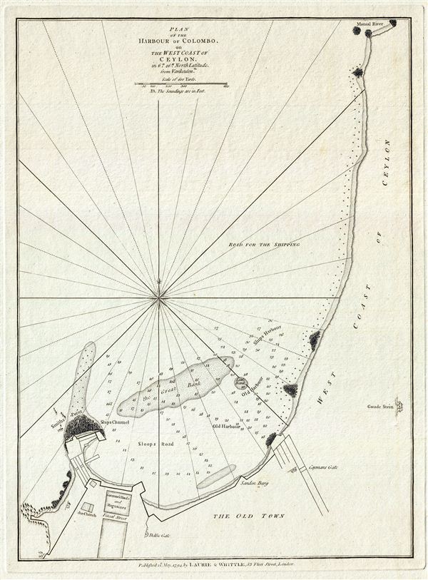
Plan of the Harbour of Colombo, on the West Coast of Ceylon.
1794 (dated) 17 x 12.5 in (43.18 x 31.75 cm) 6.041666667
1794 (dated) 17 x 12.5 in (43.18 x 31.75 cm) 6.041666667
Description
This is a fine example of Laurie and Whittle's 1794 nautical chart or maritime map of the harbor of Colombo, on the west coast of Ceylon or Sri Lanka. It covers the harbor of what is now one of the busiest ports in the world from Motual River to Smith's Point and the Old Town of Colombo.
The port of Colombo, known to Chinese, Roman and Arab traders for 2000 years, was an important terminal for trade during the colonial period. The Portuguese discovered and controlled the port and traded cinnamon there in the 16th century. They also built the fort in 1517, which can be seen on this map. The area is till today known as 'Fort.' The Dutch eventually gained control of the port in 1656 and it became the capital of the Dutch Maritime Provinces, controlled by the Dutch East India Company. In 1796, just two years after the making of this map, the British captured the Port of Colombo and eventually made it the capital of the British crown colony of Ceylon.
The map offers rich detail including countless depth soundings, notes on the sea floor, rhumb lines, shoals, buildings, place names and a wealth of other practical information for the mariner. As noted in the title, Laurie and Whittle derived the map from a much earlier 17th century plan by the Dutch East India Company chart maker Johannes van Keulen (1654-1715). This map was published by Laurie and Whittle from their offices at 53 Fleet Street, London, on May 12, 1794. It was issued independently as well as offered in their 1797 East-India Pilot, or Oriental Navigator.
Cartographer
Laurie and Whittle (fl. 1794 - 1858) were London, England, based map and atlas publishers active in the late 18th and early 19th century. Generally considered to be the successors to the Robert Sayer firm, Laurie and Whittle was founded by Robert Laurie (c. 1755 - 1836) and James Whittle (1757-1818). Robert Laurie was a skilled mezzotint engraver and is known to have worked with Robert Sayer on numerous projects. James Whittle was a well-known London socialite and print seller whose Fleet Street shop was a popular haunt for intellectual luminaries. The partnership began taking over the general management of Sayer's firm around 1787; however, they did not alter the Sayer imprint until after Sayer's death in 1794. Apparently Laurie did most of the work in managing the firm and hence his name appeared first in the "Laurie and Whittle" imprint. Together Laurie and Whittle published numerous maps and atlases, often bringing in other important cartographers of the day, including Kitchin, Faden, Jefferys and others to update and modify their existing Sayer plates. Robert Laurie retired in 1812, leaving the day to day management of the firm to his son, Richard Holmes Laurie (1777 - 1858). Under R. H. Laurie and James Whittle, the firm renamed itself "Whittle and Laurie". Whittle himself died six years later in 1818, and thereafter the firm continued under the imprint of "R. H. Laurie". After R. H. Laurie's death the publishing house and its printing stock came under control of Alexander George Findlay, who had long been associated with Laurie and Whittle. Since, Laurie and Whittle has passed through numerous permeations, with part of the firm still extant as an English publisher of maritime or nautical charts, 'Imray, Laurie, Norie and Wilson Ltd.' The firm remains the oldest surviving chart publisher in Europe. More by this mapmaker...
Source
Laurie, R., and Whittle, J., The East-India Pilot, or Oriental Navigator, on One Hundred and Eighteen Plates: Containing a Complete Collection of Charts and Plans, &c., &c. for the Navigation not only of the Indian and China Seas, but of those also between England and the Cape of Good-Hope; Improved and Chiefly Composed from the Last Work of M. D'Apres de Mannevillette; with Considerable Additions, from Private Manuscripts of the Dutch, and from Draughts and Actual Surveys Communicated By Officers of the East-India Company A New Edition, Containing One Hundred and Five Charts. (London: Laurie and Whittle) 1797.
Condition
Very good. Original platemark visible.