This item has been sold, but you can get on the Waitlist to be notified if another example becomes available, or purchase a digital scan.
1776 Baldwin Map of Benedict Arnold's Expedition to Quebec
ColonelArnold-baldwin-1776$375.00

Title
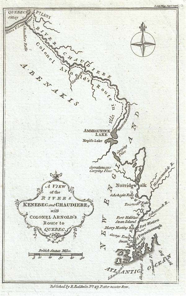
A View of the Rivers Kenebec and Chaudiere, with Colonel Arnold's Route to Quebec.
1776 (dated) 7.25 x 4.5 in (18.415 x 11.43 cm) 1 : 2280960
1776 (dated) 7.25 x 4.5 in (18.415 x 11.43 cm) 1 : 2280960
Description
This is a 1776 Richard Baldwin map of Colonel Benedict Arnold's expedition to Quebec. The map depicts from Quebec City to the Atlantic Ocean. The Kennebec (Kenebec) River, in what is today the state of Maine, and the Chaudière River, in modern-day Quebec, Canada are illustrated in detail, along with their tributaries. Colonel Arnold's route is depicted along the Chaudière River. Several important waypoints along Arnold's expedition are labeled on the map, including Fort Western (Augusta, Maine today), Fort Halifax, Norridgewock Falls (Norridgwalk), the Carrying Place between the Kennebec and Chaudière Rivers, Pointe-Levi, and the Saint Lawrence River.
Early in the American Revolutionary War, Benedict Arnold and Ethan Allen captured Fort Ticonderoga. They were aware that Quebec was lightly defended, and proposed an expedition to the Continental Congress. They initially rejected the idea, but had a change of heart after considering that the British could use Quebec to stage an invasion. Arnold had designs to lead the expedition, but was passed over in favor of Major General Phillip Schuyler of New York. Undeterred, Arnold went to General George Washington and proposed that he lead a second force through the wilderness, up the Kennebec and Chaudière Rivers, which Washington approved.
Colonel Arnold's expedition set out from Cambridge, Massachusetts on September 11, 1775 and immediately began to suffer difficulties. The boats he had commissioned were poorly made and leaked, which ruined food supplies and sickened the soldiers. The rivers did not connect, and there were several waterfalls, which meant that portages were necessary. At The Great Carrying Place (labeled on the map), a twelve mile portage was required, which included a rise in elevation of 1,000 feet. By the time Arnold and his men reached Quebec, his initial force of 1,100 men had withered to 600. Even after joining forces with Richard Montgomery, the battle was a disaster. More than 350 men were captured, Arnold was wounded, and Montgomery was killed. Arnold, however, was promoted to brigadier general for his role in leading the expedition.
While General Arnold is celebrated for his command during the Quebec expedition and the capture of Fort Ticonderoga, he is remembered in the United States more for his villainy than his heroism. General Arnold is infamous for changing sides during the American Revolution. By July 1779, Arnold was sending coded messages to the British detailing troop movements and strengths of the Continental Army. On August 3, 1780, General Arnold was given command of West Point, a strategically placed fort on the Hudson River. Its position gave the commander at West Point control over the entirety of the American-controlled Hudson River, from Albany to the British lines outside New York City. Arnold immediately offered to surrender the fort to the British Army, and accepted British terms on August 30. The plot was exposed in late September, when a British officer was captured carrying the plans for the capture of West Point, which had been given to him by General Arnold. Arnold immediately fled to a conveniently waiting Royal Navy ship which took him to New York.
Arnold was given a commission as a brigadier general in the British Army and commanded several raids and actions against colonial forces. He even suggested several brazen actions meant to end the war in favor of the British. Arnold left the United States in December 1781 and lived in exile until his death in 1801.
This map was produced and published by Richard Baldwin for publication in volume 45 of his 'The London Magazine, or, Gentleman's Monthly Intelligencer.'
Cartographer
Richard Baldwin (December, 1724 - January, 1770) was an English bookseller and publisher active in London during the middle part of the 18th century. Baldwin is best known as the publisher of the London Magazine: or, Gentleman's Monthly Intelligencer, a monthly periodical. The London Magazine chronicled some of the most important events in the 18th century including the French and Indian War and the American Revolutionary War. It was also notable for being well illustrated by with maps by Thomas Kitchin and others. Upon his death in January of 1770, control of the London Magazine passed to his son Robert Baldwin (fl. 1746 - 1810). Eventually the firm was renamed Baldwin, Cradock & Joy, then simply Baldwin and Cradock. More by this mapmaker...
Source
Baldwin, R., 'The London Magazine, or, Gentleman's Monthly Intelligencer', Vol. 45 (Sept. 1776) p.480.
Condition
Very good. Repaired tear extending three quarters of an inch across the upper left corner. Blank on verso.
References
OCLC 52137476. Jolly, D. C., Maps in British Periodicals, LOND-313. Phillips (Maps) p. 735. Guthorn, Peter J., British Maps of the American Revolution, 153-2. Nebenzahl, K., A Bibliography of Printed Battle Plans o the American Revolution, 1775-1795., 45.