
1921 General Land Office Map of Colorado

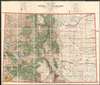
State of Colorado Compiled chiefly from the Official Records of the General Land Office with supplemental data from other map making agencies under the direction of I.P. Berthrong, Chief of Drafting Division, G.L.O.
Land Reclamation in Colorado.
- Digital Map Information
- Suitable for large format printing
- File Size: 110.35 MB
- File Type: ZIP / TIFF
- ICC color profile embedded
- Delivered instantly via download link
Land Reclamation in Colorado.
This is a highly detailed 1921 map of Colorado issued by the General Land Office in 1921. The map covers the state noting National Forests (Green), American Indian Reservations (Yellow), National Parks (Purple), Military Reserves (Red), and Reclamations Projects (Blue). The major reclamation projects, which take the form of enormous irrigation dams, appear here in western Colorado and include the Grand Valley Project and the Uncompaghre Projects. Lesser reservoirs appear here and there throughout.Publication History and Census
This map was compiled by A. F. Dinsmore, traced and lettered by William Bauman, Jr. and published by the Department of the Interior General Land officer under the supervision of Ithamar Parsons Berthrong. It was published in various editions from about 1910. The map is well represented institutionally, but uncommon on the private market.Cartographers
Ithamar Parsons Berthrong (February 26, 1853 - July 29, 1936) was an American surveyor, inventor, and draftsman active with the General Land Office of the U.S. Department of the Interior. Berthrong was born in Rochester, New York. He was made chief of the drafting division on March 23 of 1907. He is associated with many of the most important early 20th century maps issued by the GLO, among them, important maps of Arizona, Colorado, Wyoming, Oregon, Washington, and more. Further Details...
Condition
Very good. Dissected and mounted on linen.
References
Huntington Library, 436174. OCLC 8714327.