1721 De Wit Map of Flanders (Holland and Belgium)
ComitatusFlandriae-dewit-1721$900.00

Title
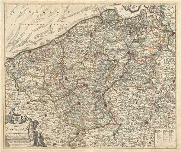
Novissima et Accuratissima Comitatus Flandriae Tabula, in qua Novae Lineae, et omnes Urbes, cum suis veris Munitionibus quae Gallis, Hispanis, Batavisqe parent.
1721 (undated) 20.5 x 24 in (52.07 x 60.96 cm) 1 : 290000
1721 (undated) 20.5 x 24 in (52.07 x 60.96 cm) 1 : 290000
Description
This is an attractive c.1721 map of Flanders by Frederik De Wit. The map depicts western portions of modern day Belgium and northern France along with parts of Holland, a region commonly known as Flanders at the time. Extends from Zeeland south to Arras in France and from Gravelines on the French coast east as far as Brussels. The map renders the entire region in extraordinary detail offering both topographical and political information noting French, Spanish and Dutch dominions. Coastal features are also beautifully noted.
The Low Countries were on the low-lying delta formed by the convergence of the Rhine, Scheldt, and Meuse rivers. This portion of the Netherlands was known successively as the Habsburg Netherlands, the Spanish Netherlands, and the Austrian Netherlands, until, in 1795, Napoleonic forces invaded and set up a new French client state, the Batavian Republic. The Low Countries, until 1581 part of the Seventeen United Provinces, were reunited by the 1815 Congress of Vienna as the United Kingdom of the Netherlands. Along with the United Provinces, this area, which hosted the world's first stock exchanges, is considered the birthplace of the modern capitalist economy.
A beautifully engraved title cartouche adorns the lower left quadrant of the map. The map was issued by Covens and Mortier and printed shortly following their 1721 acquisition of De Wit's plates from Maria De Wit.
CartographerS
Frederik de Wit (1629 - 1706) was a Dutch Golden Age cartographer active in the second half of the 17th and the early 18th centuries. De Wit was born of middle class Protestant stock in the western Netherlandish town of Gouda. He relocated to Amsterdam sometime before 1648, where he worked under Willem Blaeu. His first attributed engraved map, a plan of Haarlem for Antonius Sanderus' Flandria Illustrata, was issued around this time. He struck out on his own in 1654. The first chart that De Wit personally both drew and engraved was most likely his 1659 map of Denmark, REGNI DANIÆ Accuratissima delineatio Perfeckte Kaerte van ‘t CONJNCKRYCK DENEMARCKEN. His great wall map of the world and most famous work, Nova Totius Terrarum Orbis Tabula appeared one year later. Following the publication of his wall map De Wit quickly rose in prominence as a both cartographer and engraver. He married Maria van der Way in 1661 and through her became a citizen of Amsterdam in 1662. Around this time he also published his first major atlas, a composite production ranging in size from 17 to over 150 maps and charts. Other atlases and individual maps followed. In 1689 De Wit was granted a 15 year Privilege by the Dutch States General. (An early copyright that protected the recipient's rights to print and publish.) He was recognized with the honorific 'Good Citizen' in 1694. De Wit died in 1706 after which his wife Maria continued publishing his maps until about 1710. De Wit's son, Franciscus, had no interest in the map trade, instead choosing to prosper as a stockfish merchant. On her own retirement, Maria sold most De Wit maps and plates at a public auction. Most were acquired by Pieter Mortier and laid the groundwork for the 1721 rise of Covens and Mortier, the largest Dutch cartographic publishing house of the 18th century. More by this mapmaker...
Covens and Mortier (1721 - c. 1862) was an Amsterdam publishing firm, the successor to the extensive publishing empire built by Pierre Mortier (1661 - 1711). Covens and Mortier maps are often criticized as derivative - but this is not fully the case. Pierre Mortier lived in Paris from 1681 to 1685. There he established close relationships the the greatest French cartographers of the era, including De L'Isle and D'Anville. His business model was based upon leveraging Dutch printing technology and sophistication to co-publish state of the art French cartography. Upon Mortier's death in 1711 his firm was taken over by his son, Cornelius Mortier (1699 - 1783). Cornelius married the sister of Johannes Covens (1697 - 1774) in 1721 and, partnering with his brother in law, established the Covens and Mortier firm. Under the Covens and Mortier imprint, Cornelius and Johannes continued in Pierre's model of publishing the most up-to-date French works with permission. They quickly became one of the largest and most prolific Dutch publishing concerns of the 18th century. The firm and its successors published thousands of maps over a 120 year period from 1721 to the mid-1800s. During their long lifespan the Covens and Mortier firm published as Covens and Mortier (1721 - 1778), J. Covens and Son (1778 - 94) and Mortier, Covens and Son (1794 - c. 1862). Learn More...
Condition
Very good. Overall age toning. Some wear and fading along original centerfold. Verso repair over split along centerfold. Some spotting.
References
OCLC: 902602426.