This item has been sold, but you can get on the Waitlist to be notified if another example becomes available, or purchase a digital scan.
1817 Thomson Map of the Comparative Heights of the World's Great Mountains
ComparativeMountains2-thomson-1817$150.00

Title
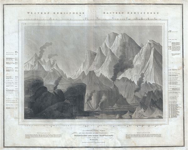
A Comparative View of the Heights of the Principal Mountains and other Elevations in the World.
1917 (undated) 20 x 25.5 in (50.8 x 64.77 cm)
1917 (undated) 20 x 25.5 in (50.8 x 64.77 cm)
Description
This is one of the earliest and most interesting takes on the comparative heights of principal mountains theme by John Thomson. Comparative mountains charts first appeared in the late 18th and early 19th century. Initially these charts focused on Europe or even signal countries, but by the early 19th century the explorations of the world's great peaks had reached a point where such a chart could be composed on a global level. John Thompson, the preeminent Scottish cartographer of the period, introduced this chart, one of the first and most interesting of the genre. Covering both the eastern and western hemispheres, this chart shows not only the heights of mountains, but also compares them to important buildings, cities, vegetation limits, and even fauna. Thompson divides his map in to the western hemisphere, on the left, and the eastern hemisphere on the right. In the Western Hemisphere, he identifies the Ecuadorian peak of Chimborazo at the highest mountains - the great Chilean peaks had not yet been discovered. Just below the summit of Chimborazo, a tiny speck represents a rare Andean Condor in flight with a highest altitude of 21,000 feet. About halfway down on the left side of Chimborazo, another little speck, this time in the shape of a man, indicated the highest elevation attained by the naturalist Alexander von Humboldt. Also identified are various high evolution towns and cities including Mexico City, Lake Toluca, Quito, and Caracas, among others. On the right hand side of Thompson's map chart, the behemoths of the Eastern Hemisphere dwarf the mountains of the west. Here, Nepal's Dhaulagiri, 27,677 feet, is identified as the world's greatest mountain. Everest and many of the other great Himalayan peaks had not yet been discovered - today we know that Dhaulagiri, though certainly a mighty peak, is only 8th. Engraved by the firm of W. and D. Lizars for John Thomson's 1817 edition of Thomson's New General Atlas.
CartographerS
John Thomson (1777 - c. 1841) was a Scottish cartographer, publisher, and bookbinder active in Edinburgh during the early part of the 19th century. Thomson apprenticed under Edinburgh bookbinder Robert Alison. After his apprenticeship, he briefly went into business with Abraham Thomson. Later, the two parted ways, John Thomson segueing into maps and Abraham Thomson taking over the bookbinding portion of the business. Thomson is generally one of the leading publishers in the Edinburgh school of cartography, which flourished from roughly 1800 to 1830. Thomson and his contemporaries (Pinkerton and Cary) redefined European cartography by abandoning typical 18th-century decorative elements such as elaborate title cartouches and fantastic beasts in favor of detail and accuracy. Thomson's principle works include Thomson's New General Atlas, published from 1814 to 1821, the New Classical and Historical Atlas of 1829, and his 1830 Atlas of Scotland. The Atlas of Scotland, a work of groundbreaking detail and dedication, would eventually bankrupt the Thomson firm in 1830, at which time their plates were sequestered by the court. The firm partially recovered in the subsequent year, allowing Thomson to reclaim his printing plates in 1831, but filed again for bankruptcy in 1835, at which time most of his printing plates were sold to A. K. Johnston and Company. There is some suggestion that he continued to work as a bookbinder until 1841. Today, Thomson maps are becoming increasingly rare as they are highly admired for their impressive size, vivid hand coloration, and superb detail. More by this mapmaker...
William Home Lizars (May 4, 1788 - March 30, 1859) was a mapmaker, engraver, draughtsman, lithographer, copperplate printer, painter, and publisher active in Edinburgh, Scotland. Born in Edinburgh to Daniel Lizars (1754 - 1812) and his wife Margaret Home, William apprenticed to his father (an engraver and publisher) in 1802. Beginning in 1804, he began studying at the Trustees' Academy and began a career as a painter. After his father died in 1812, William took over the family business, abandoning his promising career as a painter. William worked in partnership with his brother Daniel Lizars (May 24, 1793 - March 14, 1875) from 1812 until the partnership was formally dissolved on October 21, 1819. William published a jigsaw puzzle in 1822 that may have been the first jigsaw puzzle produced in Scotland. After William's death, William and Alexander Keith Johnston acquired the firm, launching another great cartographic firm. William married Henrietta Wilson in 1820. After leaving the partnership, William's brother Daniel became a bookseller. In 1832, he went bankrupt and in 1833 emigrated to Canada. He died in Ontario in 1875. Learn More...
Source
Thomson, J., Thomson's New General Atlas, 1817.
Condition
Very good. Minor wear and toning along original centerfold. Original platemark visible. Some offsetting and toning throughout. Bottom margin exhibits some wear, especially near centerfold.