This item has been sold, but you can get on the Waitlist to be notified if another example becomes available, or purchase a digital scan.
1821 Thomson Comparative Rivers Chart or Map
ComparativeRivers-thomson-1821$600.00

Title
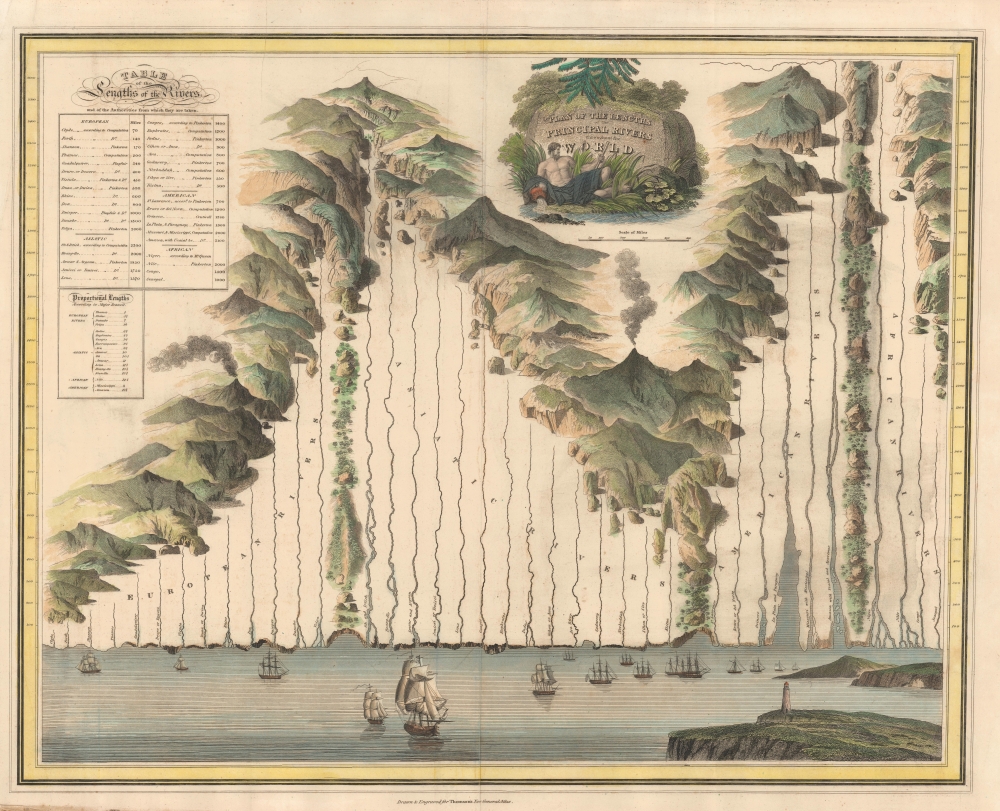
Plan of the Lengths of the Principal Rivers Throughout the World.
1821 (undated) 21 x 26 in (53.34 x 66.04 cm) 1 : 11115000
1821 (undated) 21 x 26 in (53.34 x 66.04 cm) 1 : 11115000
Description
A most unusual and attractive comparative rivers chart or map issued separately as an optional post-publication supplement to the 1821 edition Thomson's General Atlas. It is a unique angle on the comparative genre, focusing exclusively on rivers laid out comparatively in a compelling array.
A Closer Look
The rivers are divided by continent with the Amazon River taking pride of place at some 3100 miles long. The humble Nile, its full majesty yet a mystery, clocks in a poor fourth at just 2000 miles (following Pinkerton). Other impressive rivers include the Ob and Volga, both in Russia, and the Hoang Ho of China (Yellow River or Huang He). At the base of the chart is a view of the sea, with multiple sailing ships and a lighthouse. Mountains and volcanoes surround the rivers, but none are defined. A chart in the upper left compares river lengths by continent.Publication History and Census
This chart was presumably issued as an optional supplement sometime after the final 1821 edition of Thomson's General Atlas, thus accounting for its rarity. We have not seen any complete editions of the atlas containing this chart. We see no examples in the OCLC, nor separate examples in any other institutional catalog. The chart was reissued in 1851 by George Phillip and Son.Cartographer
John Thomson (1777 - c. 1841) was a Scottish cartographer, publisher, and bookbinder active in Edinburgh during the early part of the 19th century. Thomson apprenticed under Edinburgh bookbinder Robert Alison. After his apprenticeship, he briefly went into business with Abraham Thomson. Later, the two parted ways, John Thomson segueing into maps and Abraham Thomson taking over the bookbinding portion of the business. Thomson is generally one of the leading publishers in the Edinburgh school of cartography, which flourished from roughly 1800 to 1830. Thomson and his contemporaries (Pinkerton and Cary) redefined European cartography by abandoning typical 18th-century decorative elements such as elaborate title cartouches and fantastic beasts in favor of detail and accuracy. Thomson's principle works include Thomson's New General Atlas, published from 1814 to 1821, the New Classical and Historical Atlas of 1829, and his 1830 Atlas of Scotland. The Atlas of Scotland, a work of groundbreaking detail and dedication, would eventually bankrupt the Thomson firm in 1830, at which time their plates were sequestered by the court. The firm partially recovered in the subsequent year, allowing Thomson to reclaim his printing plates in 1831, but filed again for bankruptcy in 1835, at which time most of his printing plates were sold to A. K. Johnston and Company. There is some suggestion that he continued to work as a bookbinder until 1841. Today, Thomson maps are becoming increasingly rare as they are highly admired for their impressive size, vivid hand coloration, and superb detail. More by this mapmaker...
Condition
Good. Some foxing and centerfold wear.