1926 U.S. Coast and Geodetic Survey Map of Alaska Surveys
ConditionAlaska-uscgs-1926$175.00


Title
U.S. Coast and Geodetic Survey. Condition of Field Work Alaska. June 30, 1926.
1926 (dated) 33.5 x 44 in (85.09 x 111.76 cm) 1 : 2500000
1926 (dated) 33.5 x 44 in (85.09 x 111.76 cm) 1 : 2500000
Description
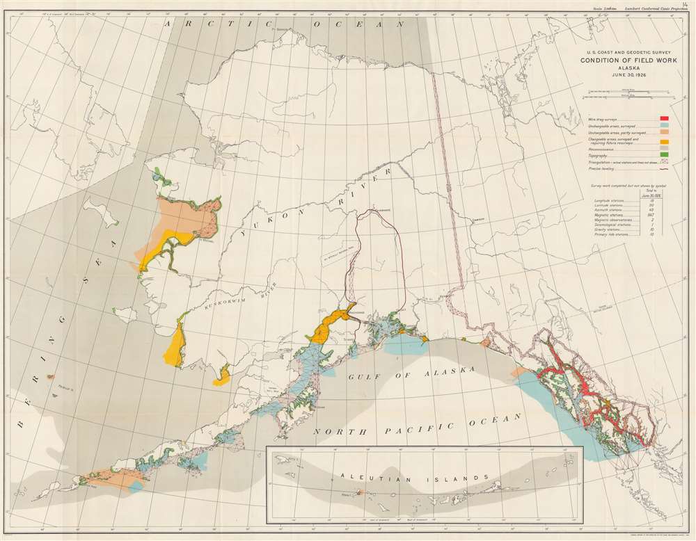
This is a 1926 U.S. Coast and Geodetic Survey map of Alaska.
Hydrographic Surveys of Alaska
Created for the Annual Report of the Director, United States Coast and Geodetic Survey of 1926, the 'condition' of field work accomplished by the agency is illustrated, using different forms of notation. 'Condition' means the total amount of field work accomplished to date. Hydrography surveys are depicted in light blue and have been completed in the Alexander Archipelago and in the bays near Cordova, Valdez, Seward, Anchorage, and Kodiak, as well as in places along the Alaska Peninsula. Other hydrographic surveys using the wire drag method and are illustrated in red, which have also been undertaken in the Alexander Archipelago. In wire drag surveys, a wire is attached to two ships or boats and set to a certain depth by a system of weights and buoys. The wire is then dragged between two points, and if it encounters an obstacle, the wire becomes taut and forms a 'V'. This reveals submerged rocks, wrecks, and other obstructions with more accuracy, along with an accurate reading of depth. Hydrographic surveys along the Alaskan coast have also only been partially completed, which are shaded in a peach color. An intriguing distinction is also made with respect to the hydrographic surveys conducted in Alaska. Per the map, some of the areas are changeable, which, accordingly, have been surveyed but will require future resurveys. These areas are depicted in yellow.Topographic Surveys of Alaska
Topographic surveys, which have only been conducted along certain coastal areas, are illustrated in green. Triangulation surveys are depicted by the red interconnected triangles and have been conducted along the border between Alaska and Canada and extensively in the Alexander Archipelago and the bays near Cordova, Valdez, Seward, and Anchorage. Triangulation surveys have also been conducted along the coastline between St. Michael and Nome. Reconnaissance work has also been completed extensively in the Bering Sea and also in the Arctic Ocean and around the Aleutian Islands.The Key to the Map!
A key explaining the different notations utilized on the map is located at the top right, and a table just below the key lists other forms of survey work completed in the region. The table states that extensive survey work has been completed in Alaska, particularly the nearly 850 magnetic stations that have been established.Publication History
This map was produced by the U.S. Coast and Geodetic Survey for inclusion in the Annual Report of the Director of the Coast and Geodetic Survey. The director in 1926 was E. Lester Jones. The separate map does not appear in OCLC and about a half dozen examples of the full report are cataloged in the database.Cartographer
The Office of the Coast Survey (1807 - present) founded in 1807 by President Thomas Jefferson and Secretary of Commerce Albert Gallatin, is the oldest scientific organization in the U.S. Federal Government. Jefferson created the "Survey of the Coast," as it was then called, in response to a need for accurate navigational charts of the new nation's coasts and harbors. The spirit of the Coast Survey was defined by its first two superintendents. The first superintendent of the Coast Survey was Swiss immigrant and West Point mathematics professor Ferdinand Hassler. Under the direction of Hassler, from 1816 to 1843, the ideological and scientific foundations for the Coast Survey were established. These included using the most advanced techniques and most sophisticated equipment as well as an unstinting attention to detail. Hassler devised a labor intensive triangulation system whereby the entire coast was divided into a series of enormous triangles. These were in turn subdivided into smaller triangulation units that were then individually surveyed. Employing this exacting technique on such a massive scale had never before been attempted. Consequently, Hassler and the Coast Survey under him developed a reputation for uncompromising dedication to the principles of accuracy and excellence. Unfortunately, despite being a masterful surveyor, Hassler was abrasive and politically unpopular, twice losing congressional funding for the Coast Survey. Nonetheless, Hassler led the Coast Survey until his death in 1843, at which time Alexander Dallas Bache, a great-grandson of Benjamin Franklin, took the helm. Bache was fully dedicated to the principles established by Hassler, but proved more politically astute and successfully lobbied Congress to liberally fund the endeavor. Under the leadership of A. D. Bache, the Coast Survey completed its most important work. Moreover, during his long tenure with the Coast Survey, from 1843 to 1865, Bache was a steadfast advocate of American science and navigation and in fact founded the American Academy of Sciences. Bache was succeeded by Benjamin Pierce who ran the Survey from 1867 to 1874. Pierce was in turn succeeded by Carlile Pollock Patterson who was Superintendent from 1874 to 1881. In 1878, under Patterson's superintendence, the U.S. Coast Survey was reorganized as the U.S. Coast and Geodetic Survey (C & GS) to accommodate topographic as well as nautical surveys. Today the Coast Survey is part of the National Oceanic and Atmospheric Administration or NOAA as the National Geodetic Survey. More by this mapmaker...
Source
Jones, E. Lester, Annual Report of the Director, United States Coast and Geodetic Survey to the Secretary of Commerce for the Fiscal Year Ended June 30, 1926 (Washington: Government Printing Office) 1926.
Condition
Very good. Slight wear and toning along original fold lines.