1926 U.S. Coast and Geodetic Survey Map of Puerto Rico and the Virgin Islands
ConditionPuertoRico-uscgs-1926$175.00

Title
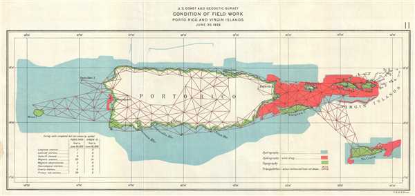
U.S. Coast and Geodetic Survey Condition of Field Work Porto Rico and Virgin Islands June 20, 1926.
1926 (dated) 7 x 14.5 in (17.78 x 36.83 cm) 1 : 1138000
1926 (dated) 7 x 14.5 in (17.78 x 36.83 cm) 1 : 1138000
Description
This is a 1926 U.S. Coast and Geodetic Survey map of Puerto Rico and the Virgin Islands. The map depicts the island of Puerto Rico (Porto Rico) and the Virgin Islands. Culebra Island and Vieques Island, districts of Puerto Rico, and Mona Island, an uninhabited nature preserve, are labeled. These islands are part of Puerto Rico. Desecheo Island is also labeled, and is an uninhabited nature preserve administered by the U.S. Fish and Wildlife Service. In the Virgin Islands, St. Thomas, St. John, and St. Croix in the U.S. Virgin Islands are labeled, as well as Tortola in the British Virgin Islands.
Created for the Annual Report of the Director, United States Coast and Geodetic Survey of 1926, the 'condition' of field work accomplished by the agency is illustrated, using different forms of notation. 'Condition' means the total amount of field work accomplished to date. Hydrography surveys are depicted in light blue and have been completed around all the islands in the region. Other hydrographic surveys using the wire drag method and are illustrated in red, which have also been extensively undertaken. In wire drag surveys, a wire is attached to two ships or boats and set to a certain depth by a system of weights and buoys. The wire is then dragged between two points, and if it encounters an obstacle, the wire becomes taut and forms a 'V'. This reveals submerged rocks, wrecks, and other obstructions with more accuracy, along with an accurate reading of depth. Topographic surveys, which cover the entirety of the smaller islands and the coastline of Puerto Rico itself, are illustrated in green. Triangulation surveys are depicted by the red interconnected triangles and, with the exception of sections of the interior of Puerto Rico, have been employed extensively throughout the region.
A key explaining the different notations utilized on the map is located along the bottom border, and a table in the lower left corner lists other forms of survey work completed in the region. The table states that, in Puerto Rico alone, the only type of station which has not been established is a gravity station, whereas in the Virgin Islands, only magnetic stations and primary tide stations have been set up.
This map was produced by the U.S. Coast and Geodetic Survey for inclusion in the Annual Report of the Director of the Coast and Geodetic Survey. The director in 1926 was E. Lester Jones.
Cartographer
The Office of the Coast Survey (later the U.S. Geodetic Survey) (1807 - present), founded in 1807 by President Thomas Jefferson and Secretary of Commerce Albert Gallatin, is the oldest scientific organization in the U.S. Federal Government. Jefferson created the "Survey of the Coast," as it was then called, in response to a need for accurate navigational charts of the new nation's coasts and harbors. The first superintendent of the Coast Survey was Swiss immigrant and West Point mathematics professor Ferdinand Hassler. Under the direction of Hassler, from 1816 to 1843, the ideological and scientific foundations for the Coast Survey were established. Hassler, and the Coast Survey under him developed a reputation for uncompromising dedication to the principles of accuracy and excellence. Hassler lead the Coast Survey until his death in 1843, at which time Alexander Dallas Bache, a great-grandson of Benjamin Franklin, took the helm. Under the leadership A. D. Bache, the Coast Survey did most of its most important work. During his Superintendence, from 1843 to 1865, Bache was steadfast advocate of American science and navigation and in fact founded the American Academy of Sciences. Bache was succeeded by Benjamin Pierce who ran the Survey from 1867 to 1874. Pierce was in turn succeeded by Carlile Pollock Patterson who was Superintendent from 1874 to 1881. In 1878, under Patterson's superintendence, the U.S. Coast Survey was reorganized as the U.S. Coast and Geodetic Survey (C & GS or USGS) to accommodate topographic as well as nautical surveys. Today the Coast Survey is part of the National Oceanic and Atmospheric Administration or NOAA. More by this mapmaker...
Source
Jones, E. Lester, Annual Report of the Director, United States Coast and Geodetic Survey to the Secretary of Commerce for the Fiscal Year Ended June 30, 1926 (Washington: Government Printing Office) 1926.
Condition
Very good. Slight wear along original fold lines. Blank on verso.