
1944 Army Map Service Map of Congressional Districts in the United States

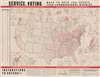
Service Voting. Maps to Help You Locate Your Congressional District.
Enabling the armed services vote during WWII.
- Digital Map Information
- Suitable for large format printing
- Full resolution TIFF file
- ICC color profile embedded
- Delivered instantly via download link
Enabling the armed services vote during WWII.
This is a 1944 Army Map Service map of the United States created to direct U.S. service personnel to their congressional district. The map reflects a broad effort during World War II (1939 - 1945) to help actively servering soliders cast their votes in the 1944 Presidental Election.A Closer Look
Red lines delineate congressional districts within states, all of which are numbered. Congressional districts in larger cities appear as inset maps. Each city is labeled with a letter corresponding to the appropriate inset. Further insets detail districts in Massachusetts and Rhode Island. An alphabetical list of state capitals appears outside the left border with voting instructions along the bottom border.Military Voting in the United States
The United States first faced a presidential election during a major war in 1864 during the American Civil War (1861 - 1865). That year, the issue of enabling active-duty soldiers to vote sparked political uproar. Republicans (who controlled state legislatures) enacted short-lived measures allowing soldiers to vote. Many Democrats opposed the measures, believing that soldiers would simply support their commander-in-chief (at the time Abraham Lincoln) and be 'herded along' by superior officers. Another debate raged over whether a soldier actively fighting in a war retained their right to vote, or whether that right was among the personal freedoms forfeited while serving.Soldier Voting and the Election of 1944
These same controversies reappeared during World War II (1939 - 1945) and the 1944 presidential election. The absentee voting system had not advanced significantly since 1864. In addition, the logistics of providing ballots to highly mobile soldiers worldwide were nearly insurmountable. At the time, many states required absentee ballots to be requested, which meant a soldier would need to write to state election officials for a request form, wait for that form to be delivered (if it appeared at all), fill out the form, return it to the state election officials, and finally wait for their ballot to be mailed. Proponents of this (impossible) method also wanted candidates' names printed on ballots, which meant waiting for the nominating conventions, making it even less likely that personnel overseas would receive their ballots before the election. Moreover, members of Congress from southern states objected to sending ballots if soldiers were exempt from poll taxes.In the end, the bill that passed encouraged states to change their absentee ballot procedures to enable soldiers participation. It also allowed for state governors to adopt the 'Official Federal War Ballot,' which 20 states authorized. This ballot featured blank spaces where soldiers could write the names of their preferred candidates for federal offices, and the bill stated that ballots could not be declared invalid for spelling mistakes as long as 'the candidate intended by the voter is plainly identifiable.' In the end, an estimated 2.7 million absentee ballots from service personnel were accepted out of approximately 9 million citizens in the armed forces, representing about a 30% turnout and 5.6% of the vote count. Many frontline soldiers didn't vote because they either didn't see that it affected them or there was too much hassle. Rear echelon troops, however, were very enthusiastic. Members of an African American artillery unit had 'huge voting placards hanging near the mess tent,' and the men crowded around looking for their respective state's voting requirements. According to the Chicago Tribune, there were crowds of American personnel in London's West End cheering election slogans on election night.
Publication History and Census
This map was prepared by the Army Map Service and distributed to military units, likely worldwide. This is the only known cataloged example.Cartographer
The Army Map Service (AMS) (1941 - 1968) was the military cartographic agency of the U.S. Department of Defense and part of the U.S. Army Corps of Engineers. The AMS compiled, published, and distributed military topographical maps and other related materials for use by the U.S. Armed Forces. They also prepared maps for space exploration, intelligence reports, and the establishment of world geodetic control networks. Formed during World War II, by the end of the war the Army Map Service had prepared 40,000 maps. 3,000 different maps were created for the Normandy invasion alone. The AMS was instrumental in the Korean War and the Vietnam War, and during all three of these conflicts distributed tens of millions of maps to U.S. servicemen. On September 1, 1968, the AMS was resdesignated the U.S. Army Topographic Command, and continued under this name as an independent organization until January 1, 1972 when it was merged with the new Defense Mapping Agency and renamed the DMA Topographic Center. The Defense Mapping Agency was added to the National Imagery and Mapping Agency on October 1, 1996, which was redesigned the National Geospatial-Intelligence Agency in 2003. Further Details...
Condition
Good. Mounted on heavy linen.