1522 / 1541 Laurent Fries Map of Southeast Asia
EastIndies-fries-1522$2,750.00

Title
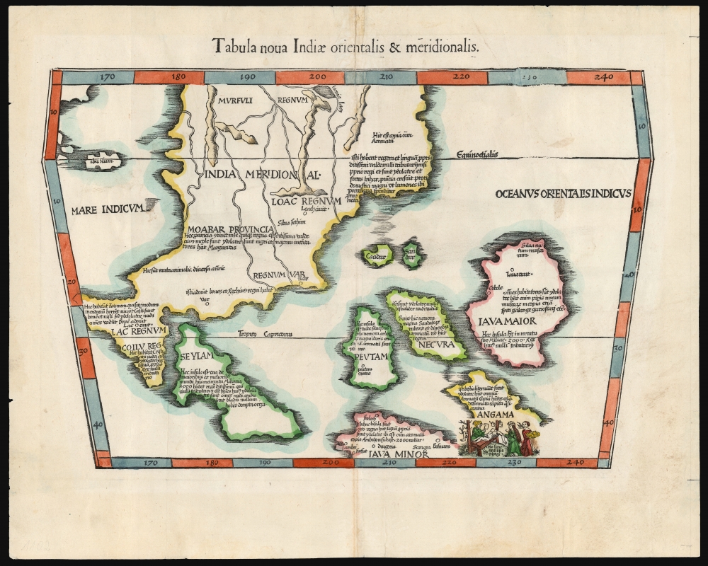
Tabula nova Indiae orientalis et meridionalis.
1522 (undated) 11.75 x 16.75 in (29.845 x 42.545 cm) 1 : 11400000
1522 (undated) 11.75 x 16.75 in (29.845 x 42.545 cm) 1 : 11400000
Description
A groundbreaking work, this 1522 Lorenz Fries map is the first European printed map to focus on Southeast Asia and the East Indies. Fries attempted to incorporate Marco Polo's geographical reports of Southeast Asia into geography derived topographically from the world maps of Waldseemüller (1507) and Martellus (c. 1490.) It was also one of the first maps included in an edition of Ptolemy's Geographia to attempt the portrayal of the world to the east of the world known to that 2nd-century geographer.
The Framework
The map utilizes Ptolemy's trapezoidal projection but retains few of Ptolemy's assumptions since its focus area lies beyond what appears in his maps. The map is dominated by the so-called 'Dragon's Tail:' a massive imaginary peninsula extending from China southwards around and into the Indian Ocean. In the northwest corner is a glimpse of the Ptolemaic Malay Peninsula. The southeastern corner of the map presents an archipelago corresponding with the modern East Indies. The islands included here, added to an imaginary ocean beyond an imaginary peninsula, cannot be expected to reflect the position of any actual places accurately. Nevertheless, the present work is important beyond its detail: it is the first map to specify the idea of the East Indies. Suarez succinctly describes the present map as the'first printed map of European origin devoted to Southeast Asia and its islands, and as such… a cartographical landmark, codifying the recognition of southeast Asia as a distinct entity.'
Applying Marco Polo to the Map
The map contains many place names, virtually all derived from the 13th-century reports of Marco Polo: these represent the earliest European reports of the east parts of the world. The difficulty arises from Polo's failure to accompany his narrative with accurate directions. Many of the places he visited can now be identified, but geographers of the 16th century struggled to trace the Venetian's narrative on the maps they were concocting. On the peninsular mainland, the placenames 'Mursuli' and 'Moabar' actually refer to places in India; 'Loac' is in Thailand, and the kingdom of 'Coilu' is understood to be in Malaya. So, a considerable part of Fries' efforts place Marco Polo's travels further east than they belong. A similar distortion occurs with the islands beyond the peninsula: 'Seylam' corresponds to Sri Lanka; Java Minor is Sumatra. 'Peutam' has been identified as Bintan Island in Indonesia, but 'Angama' and 'Necura' are understood to be the Andaman and Nicobar Islands.Filled with Stories
Fries has incorporated abundant text descriptions: like many of the placenames, these are sourced from Marco Polo. Overwhelmingly, they describe the inhabitants of the islands as beastly idol worshippers and describe the islands as filled with abundant spices, pepper, mustard, and ginger. This provided the European reader with a dual enticement: here, certainly, were opportunities for great wealth, but also, there were souls that the Christian reader would feel obligated to save. That said, Fries's portrayal of the Andaman islanders as anthropophages (by means of a cheerful cannibal scene) seems intended to sensationalize rather than to inspire missionary zeal. In the midst of these idolatrous lands, he notes that 'Coilu' is also inhabited by Christians and Jews, perhaps offering the hope of allies.The Indian Ocean and Ptolemy's Appendix
Fries' geography in many areas radically moved beyond Ptolemaic assumptions but made more gradual shifts in other areas. One of the notable features of early world maps based on Ptolemy is that the Indian Ocean was believed to be an inland sea, with the southern part of Africa continuing eastward to meet China beyond the Malay Peninsula. By the time Fries produced this map, Europeans understood that such a 'land bridge' between Africa and China did not exist (Portuguese navigation had proven this point), but there was as yet no exploratory evidence to indicate what precisely was beyond the Indian Ocean and the Malay Peninsula. The solution offered by Henry Martellus in 1490 (which Waldseemüller adopted and Fries promoted) was to truncate the 'land bridge' at a point some distance south of India-beyond-the-Ganges. What remained of the land mass once thought to enclose the Indian Ocean was a massive, inward-curving peninsula - sometimes referred to as the Dragon's Tail. This feature graces many late 15th and early 16th-century world maps, including Waldseemüller's 1507 and 1513 maps. Fries incorporates the same feature on both of his 'modern' world maps, his map of China and Japan, and the present work.Publication History and Census
This map was first issued in the 1522 Lorenz Fries Strasbourg edition of Ptolemy's Geographia. A further edition was produced in that same city in 1525. After that, two further editions of 1535 and 1541 were published in Lyon and Vienne-in-the-Dauphane, respectively. This example conforms typographically to the 1541 edition. Overall, the four editions of Fries' Ptolemy are well represented in institutional collections.CartographerS
Lorenz Fries (c. 1490 – 1531) was a German cartographer, cosmographer, astrologer, and physician based in Strasbourg. Little is known of Fries' early life. He may have studied in Padua, Piacenza, Montpellier, and Vienna, but strong evidence of this is unfortunately lacking. The first recorded mention of Fries on a 1513 Nuremberg broadside. Fries settled in Strasbourg in March of 1519, where he developed a relationship with the St. Die scholars, including, among others, Walter Lud, Martin Ringmann, and Martin Waldseemüller. There, he also befriended the printer and publisher Johann Grüninger. Although his primary profession was as a doctor, from roughly 1520 to 1525, he worked closely with Grüninger as the geographic editor of various maps and atlases based upon the work of Martin Waldseemüller. Although his role is unclear, his first map seems to have been a 1520 reissue of Waldseemüller's world map of 1507. Around this time, Fries also began working on Grüninger's reissue of Waldseemüller's 1513 edition of Ptolemy's Geographie Opus Novissima. That edition included three new maps by Fries based upon the Waldseemüller world map of 1507 – two of these, his maps of East Asia and Southeast Asia, are quite significant as the first specific maps of these regions issued by a European publisher. In 1525, Fries decided to leave Strasbourg and surrendered his citizenship, relocating to Trier. In 1528, he moved to Basel. Afterward, he relocated to Metz where he most likely died. In addition to his cartographic work, Fries published tracts on medicine, religion, and astrology. More by this mapmaker...
Martin Waldseemüller (September 11, 1470 - March 16, 1520) was a German cartographer, astronomer, and mathematician credited with creating, along with Matthias Ringmann, the first map to use the placename America. He was born in Wolfenweiler, near Freiburg im Breisgau. Waldseemüller studied at the University of Freiburg and, on April 25, 1507, became a member of the Gymnasium Vosagese at Saint-Dié. Martin Waldseemüller was a major proponent of theoretical or additive cartography. Unlike contemporary Portuguese and Spanish cartographers, who left maps blank where knowledge was lacking, Waldseemüller and his peers speculated based upon geographical theories to fill unknown parts of the map. He is best known for his Universalis Cosmographia a massive 12-part wall map of the world considered the first map to contain the name America, today dubbed as 'America's Birth Certificate'. This map also had significance on other levels, as it combined two previously unassociated geographical styles: Ptolemaic Cartography, based on an ancient Greek model, and the emergent 'carta marina', a type of map commonly used by European mariners in the late 15th and 16th centuries. It also extended the traditional Ptolemaic model westward to include the newly discovered continent of America, which Waldseemüller named after the person he considered most influential in its discovery, Amerigo Vespucci. When Waldseemüller died in 1520, he was a canon of the collegiate Church of Saint-Dié. In contemporary references his name is often Latinized as Martinus Ilacomylus, Ilacomilus, or Hylacomylus. Learn More...
Source
Fries, L., Claudii Ptolemaei Alexandrini Geographicae enarrationis libri octo, (Vienne in the Dauphane: Servetus) 1541.
Condition
Very good. Some marginal reinforcements and wear at centerfold.
References
OCLC 57232880 (miscataloged). cfRumsey, 11325.078. Suarez, T., Early Mapping of Southeast Asia, pp. 114-118, Fig. 62.