1854 Exene Tobey Schoolgirl Manuscript Map of Connecticut
Connecticut-exenetobey-1854$3,500.00

Title
Connecticut Exene Tobey 1854.
1854 (dated) 21.5 x 21.5 in (54.61 x 54.61 cm)
1854 (dated) 21.5 x 21.5 in (54.61 x 54.61 cm)
Description
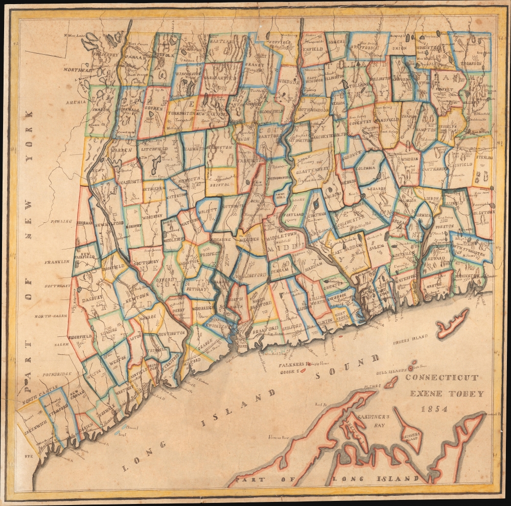
This is an attractive 1854 schoolgirl manuscript map of Connecticut drawn by 13-year-old Exene E. Tobey of New Canaan.
The goals of these exercises were more far-reaching than teaching geography. Girls learned penmanship, with maps commonly incorporating three or more lettering styles. Mapmaking sharpened the retention and recall of factual information. Students were encouraged to take pains in their draftsmanship and often achieved beautiful flourishes of artistic expression. But most peculiar to the American iterations of educational mapping was the goal of instilling a sense of civic pride and responsibility. Indeed, the key desired result of the education of girls in the post-Revolutionary-War United States was to prepare for the education of the next generation of American citizens, a patriotic duty which would primarily fall on the shoulders of these young women.
For a good overview of Schoolgirl Maps, see Betty Mason's '19th Century Schoolgirls Were Incredibly Good at Drawing Maps.' Published July 27, 2016 by National Geographic.
A Closer Look
The artfully drawn map covers all of Connecticut and the eastern forks of Long Island, including Shelter Island, Gardiner's Island, and Fisher Island. The map is contracted on the east-west axis, likely to accommodate the nearly square paper. The whole is whimsically well executed with town, county, and topographical detail. It features a few interesting points of local history, such as Devil's Den in Weston County, where from April 25 to April 27, 1777, residents of Redding and Weston were thought to have taken refuge to escape harassment by a column of British troops marching north from Long Island Sound to destroy a military supply depot in Danbury. It also names Yale University, the Connecticut Literary Institute (Suffield School from 1816), and various religious societies, including the Shakers (Enfield Co.).Exene Toby
Exene E. Tobey (1841 - February 1934) was born in New Canaan, Connecticut in 1841, the daughter of George Ephriam Tobey (1745 - 1823) and Abigail Knapp (1751 - 1824). George Ephriam Tobey appears to have been a man of some means and left behind a moderate estate, though the nature of his work remains unknown. Exene married Martin Pratt Fitch (1832 - 1866) in 1858, becoming Exene Tobey Fitch. In 1863, Fitch was drafted to fight the American Civil War (1861 - 1865) and died in 1866 of typhoid contracted during his service. In 1910, the widow Exene married Samuel A. Bennet, becoming Exene Tobey Fitch Bennett.Schoolgirl Maps
While the use of mapmaking in teaching is first seen in Europe, mainly England, the Schoolgirl Map became a peculiarly American pedagogical tool in the first part of the 19th Century, a period in which standards and purposes in women's education were changing. While boys were frequently taught the practical execution of surveys and charts, the production of attractive and informative maps appears to have been primarily the domain of young women. Such maps can be found of the world, the United States, or specific states. These were usually based on generally available reference maps, such as those found in the atlases produced by Carey and Lea, Finley, and Mitchell.The goals of these exercises were more far-reaching than teaching geography. Girls learned penmanship, with maps commonly incorporating three or more lettering styles. Mapmaking sharpened the retention and recall of factual information. Students were encouraged to take pains in their draftsmanship and often achieved beautiful flourishes of artistic expression. But most peculiar to the American iterations of educational mapping was the goal of instilling a sense of civic pride and responsibility. Indeed, the key desired result of the education of girls in the post-Revolutionary-War United States was to prepare for the education of the next generation of American citizens, a patriotic duty which would primarily fall on the shoulders of these young women.
For a good overview of Schoolgirl Maps, see Betty Mason's '19th Century Schoolgirls Were Incredibly Good at Drawing Maps.' Published July 27, 2016 by National Geographic.
Publication History and Census
This map is a unique manuscript.Condition
Average. Toning and some foxing. Laid down on archival tissue. Several large tears, mended and stabilized on verso.