This item has been sold, but you can get on the Waitlist to be notified if another example becomes available, or purchase a digital scan.
1968 Hallwag Pictorial Map of Space Exploration
ConquestSpace-hallwag-1968$250.00

Title
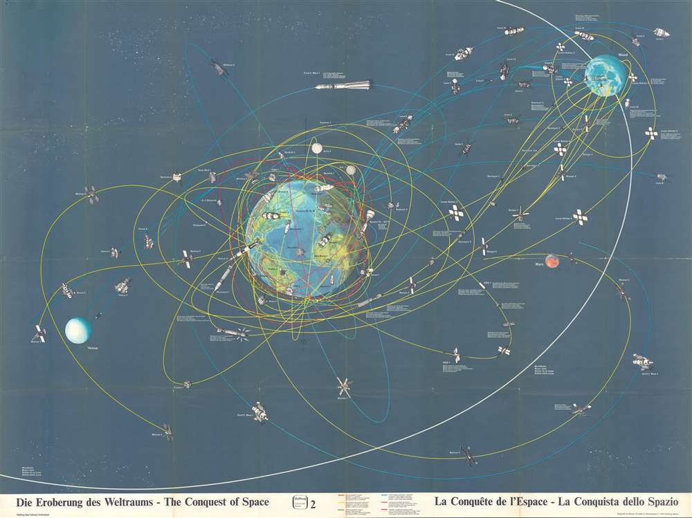
Die Eroberung des Weltraums - The Conquest of Space - La Conquête de l'Espace - La Conquista dello Spazio.
1968 (dated) 33 x 44 in (83.82 x 111.76 cm)
1968 (dated) 33 x 44 in (83.82 x 111.76 cm)
Description
This is a 1968 Hallwag pictorial map of space exploration. With Earth just to the left of center, the map depicts the presumed trajectories of both manned and unmanned spacecraft in orbit around the Earth, the Moon, and flying by Mars.
The Space Race
This piece was created at the height of the Space Race, just before the United States began launching manned Apollo missions after the tragic fire that killed all three astronauts of Apollo 1. These trajectories are printed in different colors so that each spacecraft can be properly attributed to the nation responsible for its construction and subsequent launch. Orange lines represent manned missions launched by the United States, of which Mercury, Gemini 6, and Gemini 10 are referenced. The vast number of yellow lines, including the one associated with the now celebrated Saturn V rocket, mark unmanned missions launched by the United States. Of all the unmanned missions launched by the U.S., particular attention is paid to the Surveyor, Ranger, Mariner, and Lunar Orbiter programs. Numerous missions launched by the Soviet Union, the United States' main competitor in the Space Race, are also promoted. Two Soviet manned missions, highlighted by green lines, are illustrated here: Soyuz 1 and Wostok. The numerous blue lines curling their way toward the Moon, Venus, and Mars, trace Soviet unmanned missions, including those that were part of the Luna program and the Zond program. The handful of dark red lines orbiting the Earth mark missions launched by the U.K., Canada, France, and Italy.Publication History and Census
This map was created by Hallwag and copyrighted in 1968. The OCLC records examples as being part of the institutional collections at the University of British Columbia and The British Library. An example is also part of the David Rumsey Map Collection at Stanford University.Condition
Very good. Wear and toning along original fold lines Closed tear extending one half inch into printed area in upper left corner professionally repaired on verso. Text and printed images on verso. Attached to original binder.
References
Rumsey 11625.004.