1969 Hallwag Pictorial Map of Space Exploration
ConquestSpace-hallwag-1969-2$500.00


Title
Die Eroberung des Weltraums - The Conquest of Space - La Conquête de l'Espace - La Conquista dello Spazio.
1969 (dated) 33 x 44 in (83.82 x 111.76 cm)
1969 (dated) 33 x 44 in (83.82 x 111.76 cm)
Description
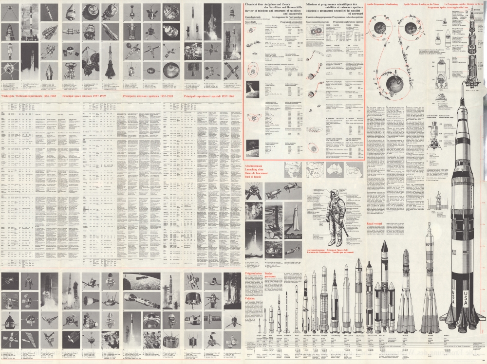
This is a 1969 Hallwag pictorial map of space exploration, created shortly after American astronauts Neil Armstrong and Buzz Aldrin landed on the Moon. The map depicts the trajectories of both manned and unmanned spacecraft in orbit around the Earth, the Moon, and flying by Mars. These trajectories are printed in different colors so that each spacecraft can be properly attributed to the nation responsible for its launch.
Understanding the Coding
Orange lines represent manned missions launched by the United States, of which Mercury, Gemini 6, Gemini 10, and Apollo 8, 10, and 11 are included. This edition, the second of which we are aware, was updated specifically to include the successful 1969 Moon landing. The proportionately large number of yellow lines, including the one associated with the now celebrated Saturn V rocket, mark unmanned missions launched by the United States. Of these American-launched unmanned missions, particular attention is paid to the Surveyor, Ranger, Mariner, and Lunar Orbiter programs. Numerous spacecraft launched by the Soviet Union, the United States' main competitor in the Space Race, are also promoted. Two Soviet manned missions, highlighted in green, are illustrated here: Soyuz 1 and Wostok. The blue lines curling their way toward the Moon, Venus, and Mars, trace Soviet unmanned missions, including those of the Luna and Zond programs. The handful of dark red lines orbiting the Earth mark missions launched by the U.K., Canada, France, and Italy.Publication History and Census
This map was created by Hallwag and copyrighted in 1969. At least three editions of this map were published, this being an example of the second, 1969. The major differences focus on the Apollo missions. The first edition was published before the Apollo program began launching missions, while the second includes Apollo 8-11, the first manned mission to the Moon. We note a third bearing a 1974/1975 date. The OCLC records examples at the University of British Columbia and the British Library, although it is unclear whether these represent the first or second editions. An example of the second edition is also part of the David Rumsey Map Collection at Stanford University.Condition
Very good. Exhibits wear along original fold lines. Some odd bubbling to the image surface - see zoom. Text and printed images on verso.
References
Rumsey 11625.004.