This item has been sold, but you can get on the Waitlist to be notified if another example becomes available, or purchase a digital scan.
1773 Hawkesworth Map of Captain Cook's First Voyage in the Paciifc
CookPacific-hawkesworth-1773$950.00

Title
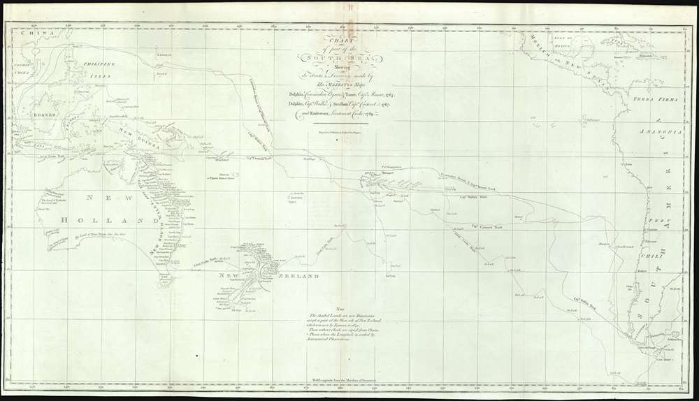
Chart of part of the South Sea, Shewing the Tracts and Discoveries made by His Majesty's Ships Dolphin, Commodore Byron, and Tamer, Captn. Mouat, 1765. Dolphin, Captn., Wallis, and Swallow, Captn. Carteret, 1767. And Endeavour, Lieutenant Cooke, 1769.
1773 (undated) 16 x 27 in (40.64 x 68.58 cm) 1 : 33550628
1773 (undated) 16 x 27 in (40.64 x 68.58 cm) 1 : 33550628
Description
This is a rare 1773 map of the South Pacific issued to illustrates English voyages of exploration in this region between 1765 and 1769, including the voyages of John Byron (1723 - 1786), Samuel Wallis (1728 - 1795), Philip Carteret (1733 - 1796), and James Cook (1728 - 1779). At the time of publication this was the most accurate extant map of this region, unveiling a wealth of new information to curious Europeans. Coverage extends from Sumatra to South America, and from Baja California and Taiwan to Tierra del Fuego, including all of Australia, Polynesia, New Zealand, the Philippines, Melanesia, and eastern Indonesia. Tasmania or Van Diemen's Land is notably attached to the Australian mainland. Tracks drawn from ship's original logs detail with precision the routes taken by Commodore Byron and Captain Mouat (1765), Captain Carteret (1767), Captain Wallis (1767), and Lieutenant James Cook (1769).
This map is well represented in many institutional collections due to the popularity of Hawkesworth's work, but is has become scarce to the market.
Cook's First Voyage
While this map shows the routes of multiple explorers, the focus of the map is 1768 - 1771 voyages of James Cook in the H.M.S. Endeavour. This was Cook's first major voyage of discovery. Ostensibly the purpose of the voyage was to observe and record the 1769 transit of Venus across the Sun which, when combined with other measurements, would enable an accurate triangulation of the distance of between the Earth and the Sun. The secondary secret purpose of the voyage, as assigned by the Admiralty, was to search the south Pacific for signs of the long speculated rich southern continent of Terra Australis or the 'South Land'. While Cook was unable to find the non-existent continent, he did accurately map numerous Polynesian islands, New Zealand, and became the first Europe to visit and map the eastern coast of Australia. Cook claimed eastern Australia (then New Holland) for England, but the annexation was not immediately recognized by the crown. Upon his return to England in 1771, Cook's journals were compiled and published by John Hawkesworth, turning Cook into an instant hero. The successful voyage itself heralded a new era of scientific exploration. The two dominant maritime powers of the time, France and Britain, would confront each other in a rivalry for power, prestige, and discovery.Publication History and Census
This map was published for the 1773 first edition of John Hawkesworth's account of James Cook's first voyage of Discovery 1768-1771. This was the only officially sanctioned account of Cook's first voyage, and as such, it was drawn from otherwise inaccessible primary source material. The incredible interest in Cook's voyages throughout Europe led to several unsanctioned copies to be issued by other publishers, but most were significantly smaller and of inferior quality. It was engraved by William Whitchurch, of Pleasant Row, Islington, London.This map is well represented in many institutional collections due to the popularity of Hawkesworth's work, but is has become scarce to the market.
CartographerS
Captain James Cook (7 November 1728 - 14 February 1779) is a seminal figure in the history of cartography for which we can offer only a cursory treatment here. Cook began sailing as a teenager in the British Merchant Navy before joining the Royal Navy in 1755. He was posted in America for a time where he worked Samuel Holland, William Bligh, and others in the mapping of the St. Lawrence River and Newfoundland. In 1766 Cook was commissioned to explore the Pacific and given a Captaincy with command of the Endeavour. What followed were three historic voyages of discovery, the highlights of which include the first European contact with eastern Australia, the discovery of the Hawaiian Islands (among many other Polynesian groups), the first circumnavigation of New Zealand, some of the first sightings of Antarctica, the first accurate mapping of the Pacific Northwest, and ultimately his own untimely death at the hands of angry Hawaiians in 1779. The influence of Cook work on the mapping and exploration of the Pacific cannot be understated. More by this mapmaker...
William Whitchurch (April 1748 - February 1794) was a British line engraver and printer active in London and Chichester in the second half of the 18th century. Whitchurch was born at St. Andrew Holborn. He apprenticed to the London engraver Joseph Ellis (1734 - c. 1800) from 1762. Whitchurch engraved maps for Cook, Dalrymple, Lerpinière, and others. Learn More...
John Hawkesworth (c. 1715 - November 16, 1773) was an English born writer and editor born London. Hawkesworth, who is said to have been self educated, succeeded Samuel Johnson as the parliamentary debate compiler for "Gentleman's Magazine". He was a deeply religious and moral map who brilliant defense of morality earned him an LL. D degree from the Archbishop of Canterbury. Hawkesworth went on to publish a series of scholarly books and essays including a 12 volume edition of Jonathan Swift's work. In 1772 Hawkesworth was commissioned by the Admiralty to compile and edit James Cook's journals. The resultant work An Account of the Voyages undertaken ... for making discoveries in the Southern Hemisphere was one of the first ethnographic account of the South Seas and was widely published in England and abroad. Though highly influential, Hawkesworth's work received heavy criticism from scholars who claim that he liberally altered much of the text in the name of morality. Learn More...
Source
Hawkesworth, J., An Account of the Voyages Undertaken by the Order of His Present Majesty for Making Discoveries in the Southern Hemisphere…, (London: W. Strahan and T. Cadell) 1773.
Condition
Good. Minor toning. Some centerfold fold wear and toning, especially near title.
References
OCLC 222052188. Tooley (Australia) #321; Shirley (BL Atlases) G.HAWK-1a #1. Perry, T. M., A Guide to Maps of Australia in Books Published 1780 - 1830, #1773.01.