This item has been sold, but you can get on the Waitlist to be notified if another example becomes available, or purchase a digital scan.
1785 Hogg Chart of Cook Inlet and Prince William Sound, Alaska
CooksRiver-hogg-1784$175.00

Title
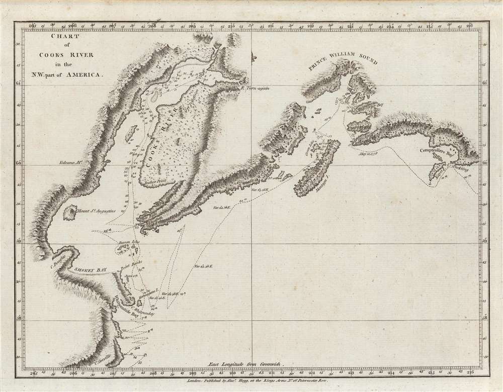
Chart of Cooks River in the N.W. part of America.
1784 (undated) 8.75 x 11.5 in (22.225 x 29.21 cm) 1 : 4400000
1784 (undated) 8.75 x 11.5 in (22.225 x 29.21 cm) 1 : 4400000
Description
An important c. 1784 nautical chart or map of the Cook Inlet and Prince William Sound along the Kenai Peninsula, just south of Anchorage, Alaska. It was the product of the third and final Pacific voyage of Captain James Cook, and was published in George William Anderson and Alexander Hogg's A New, authentic, and complete collection of voyages round the world, undertaken and performed by royal authority....
James Cook and his crew explored this region in May and June 1778 on his third Pacific voyage. The course of the H.M.S. Resolution is tracked, noting soundings, anchorages, hazards, sandbars, and variations along the route. Coastal features, mountains, and vegetation are indicated on land.
This period was significant as it included Cook's first encounter with indigenous Alaskans, very near the site of Anchorage today. Sending two crew members ashore, the interaction was peaceful and friendly, and resulted in Cook claiming the area for the British crown.
In the years after Cook's visit, traders from the Russian Shelikhov-Golikov Company set up posts along the inlet, though it is possible that they had already traded with the local people before Cook's arrival. Late in the Russian period, gold was discovered in small amounts near modern-day Anchorage, a harbinger of the much larger deposits found there in the 1880s.
The present chart is sometimes cataloged as Plate No. 17 of Anderson and Hogg's work, though no plate number is present here. The discrepancy is likely the result of multiple editions of the work being published in short order in the mid-1780s. We note the independent cataloging of this map in the holdings of six institutions, while Anderson and Hogg's entire work is more widely distributed.
A Closer Look
Coverage extends from the Prince William Sound at right to the large inlet at left now known as Cook Inlet, while the smaller inlet towards top-left is the Knik Arm, into which the Knik and Turnagain Rivers (only partially charted here) flow. The prominent landmass forming the right side of the inlet is the Kenai Peninsula.James Cook and his crew explored this region in May and June 1778 on his third Pacific voyage. The course of the H.M.S. Resolution is tracked, noting soundings, anchorages, hazards, sandbars, and variations along the route. Coastal features, mountains, and vegetation are indicated on land.
Cook Inlet
The coasts shown here were home, at least occasionally or seasonally, to the Alutiiq people for some 5,000 years before James Cook arrived in 1778. Although Cook's first inclination was to bypass the inlet, in accordance with his mission to only seek out the most promising routes of a potential northwest passage, at the urging of his crew he spent ten days surveying the inlet now bearing his name, and a month in the wider region depicted here.This period was significant as it included Cook's first encounter with indigenous Alaskans, very near the site of Anchorage today. Sending two crew members ashore, the interaction was peaceful and friendly, and resulted in Cook claiming the area for the British crown.
In the years after Cook's visit, traders from the Russian Shelikhov-Golikov Company set up posts along the inlet, though it is possible that they had already traded with the local people before Cook's arrival. Late in the Russian period, gold was discovered in small amounts near modern-day Anchorage, a harbinger of the much larger deposits found there in the 1880s.
Captain Cook's Third Voyage
By the time of his third long-distance voyage in 1776, James Cook was an experienced naval officer who had launched two successful scientific expeditions to the Pacific, while also searching for a northwest passage. On his third voyage, after briefly stopping at the Hawaiian Islands in January 1778, Cook explored the west coast of North America up to the Bering Strait before returning to Hawaii in early 1779, where he met his untimely death.Publication History and Census
This chart, based on Cook's sketches from his third expedition, was published in George William Anderson and Alexander Hogg's A New, authentic, and complete collection of voyages round the world, undertaken and performed by royal authority... in 1784 or perhaps 1785. Another edition of this chart was published in 1785 for the second edition of G. Nicol and T. Cadell's Voyage to the Pacific Ocean… Performed under the direction of Captains Cook, Clerke and Gore (Rumsey 3405.013). The two editions are nearly identical aside from the publication information at bottom here.The present chart is sometimes cataloged as Plate No. 17 of Anderson and Hogg's work, though no plate number is present here. The discrepancy is likely the result of multiple editions of the work being published in short order in the mid-1780s. We note the independent cataloging of this map in the holdings of six institutions, while Anderson and Hogg's entire work is more widely distributed.
CartographerS
Alexander Hogg (fl. c. 1778-1824) was a London based book, map, and print publisher. Hogg is best known for his publication of the journals of James Cook, but he also published a number of local plans focusing on the British Isles. His offices were based at no. 16 Paternoster Row, London, England. More by this mapmaker...
Captain James Cook (7 November 1728 - 14 February 1779) is a seminal figure in the history of cartography for which we can offer only a cursory treatment here. Cook began sailing as a teenager in the British Merchant Navy before joining the Royal Navy in 1755. He was posted in America for a time where he worked Samuel Holland, William Bligh, and others in the mapping of the St. Lawrence River and Newfoundland. In 1766 Cook was commissioned to explore the Pacific and given a Captaincy with command of the Endeavour. What followed were three historic voyages of discovery, the highlights of which include the first European contact with eastern Australia, the discovery of the Hawaiian Islands (among many other Polynesian groups), the first circumnavigation of New Zealand, some of the first sightings of Antarctica, the first accurate mapping of the Pacific Northwest, and ultimately his own untimely death at the hands of angry Hawaiians in 1779. The influence of Cook work on the mapping and exploration of the Pacific cannot be understated. Learn More...
Source
Anderson, G. W. and A. Hogg, A New, authentic, and complete collection of voyages round the world, undertaken and performed by royal authority..., (London: A. Hogg) 1784.
Condition
Very good. Light foxing.
References
OCLC 57229311, 662514190.