
This item below is out of stock, but another example (left) is available. To view the available item, click "Details."
Details
1794 Laurie and Whittle Nautical Chart or Map of the Coast of Coromandel, India
1794 (dated) $200.00
1794 Laurie and Whittle Nautical Chart or Map of the Coast of Coromandel, India
Coromandel-lauriewhittle-1794$100.00

Title
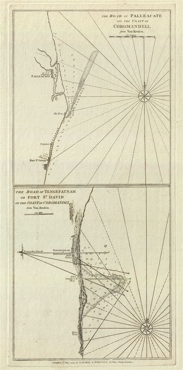
The Road of Palleacate, off the Coast of Coromandell. The Road of Tengepatnam or Fort St. David on the Coast of Coromandel.
1794 (dated) 21 x 10 in (53.34 x 25.4 cm) 1 : 76000
1794 (dated) 21 x 10 in (53.34 x 25.4 cm) 1 : 76000
Description
This is a fine example of Laurie and Whittle's 1794 nautical chart or maritime map of Palleacate (Pulicat) and Tengepatnam or Fort St. David on the Coromandel Coast in the state of Tamil Nadu, India. Essentially two maps on one sheet, the upper map details Pulicat, a historic seashore town in Tamil Nadu, India and the Fort St. George, which is situated in the modern city of Chennai, India. The lower map details fort St. David near the town of Cuddalore in Tamil Nadu, India.
The location of Fort St. George on the upper map is beautifully rendered. A church, most likely St. Mary's Church, which is the oldest Anglican Church in India, is shown. Founded in 1644, Fort St. George was the first English fortress in India. Over time, settlements around the fort grew to include the neighboring villages and eventually evolved to form the city of Madras or Chennai, which is now one of the most populous metropolitan areas in India. While Fort St. Gorge and the surrounding towns were controlled by the British when this map was drawn, Pulicat, which until 1609 was the capital of Dutch Coromandel, changed allegiances between the Dutch, Portuguese and British until in 1825 when fell fully under the British hegemony.
The map of Fort St. David notes 'A fort belonging to the Moors.' Fort St. David, originally built by a Hindu merchant, was captured by the Marathas in 1677. The English later acquired the fort in 1690 and renamed it to Fort St. David. It would eventually become the British headquarters for all of Southern India.
The map offers rich detail including countless depth soundings, notes on the sea floor, commentary on reefs, rhumb lines, sandbars, shoals, buildings, place names and a wealth of other practical information for the mariner. As noted in the title, Laurie and Whittle derived the map from a much earlier 17th century plan by the Dutch East India Company chart maker Johannes van Keulen (1654-1715). This map was published by Laurie and Whittle from their offices at 53 Fleet Street, London, on May 12, 1794. It was issued independently as well as offered in their 1797 East-India Pilot, or Oriental Navigator.
Cartographer
Laurie and Whittle (fl. 1794 - 1858) were London, England, based map and atlas publishers active in the late 18th and early 19th century. Generally considered to be the successors to the Robert Sayer firm, Laurie and Whittle was founded by Robert Laurie (c. 1755 - 1836) and James Whittle (1757-1818). Robert Laurie was a skilled mezzotint engraver and is known to have worked with Robert Sayer on numerous projects. James Whittle was a well-known London socialite and print seller whose Fleet Street shop was a popular haunt for intellectual luminaries. The partnership began taking over the general management of Sayer's firm around 1787; however, they did not alter the Sayer imprint until after Sayer's death in 1794. Apparently Laurie did most of the work in managing the firm and hence his name appeared first in the "Laurie and Whittle" imprint. Together Laurie and Whittle published numerous maps and atlases, often bringing in other important cartographers of the day, including Kitchin, Faden, Jefferys and others to update and modify their existing Sayer plates. Robert Laurie retired in 1812, leaving the day to day management of the firm to his son, Richard Holmes Laurie (1777 - 1858). Under R. H. Laurie and James Whittle, the firm renamed itself "Whittle and Laurie". Whittle himself died six years later in 1818, and thereafter the firm continued under the imprint of "R. H. Laurie". After R. H. Laurie's death the publishing house and its printing stock came under control of Alexander George Findlay, who had long been associated with Laurie and Whittle. Since, Laurie and Whittle has passed through numerous permeations, with part of the firm still extant as an English publisher of maritime or nautical charts, 'Imray, Laurie, Norie and Wilson Ltd.' The firm remains the oldest surviving chart publisher in Europe. More by this mapmaker...
Source
Laurie, R., and Whittle, J., The East-India Pilot, or Oriental Navigator, on One Hundred and Eighteen Plates: Containing a Complete Collection of Charts and Plans, &c., &c. for the Navigation not only of the Indian and China Seas, but of those also between England and the Cape of Good-Hope; Improved and Chiefly Composed from the Last Work of M. D'Apres de Mannevillette; with Considerable Additions, from Private Manuscripts of the Dutch, and from Draughts and Actual Surveys Communicated By Officers of the East-India Company A New Edition, Containing One Hundred and Five Charts. (London: Laurie and Whittle) 1797.
Condition
Very good. Original platemark visible. Two maps on one sheet.