This item has been sold, but you can get on the Waitlist to be notified if another example becomes available, or purchase a digital scan.
1794 Laurie and Whittle Nautical Chart or Map of the Coromandel Coast, India
CoromandelGolconda-lauriewhittle-1794$175.00

Title
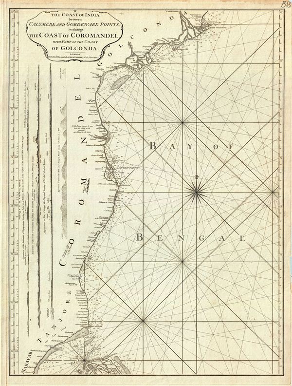
The Coast of India between Calymere and Gordeware Points, including the Coast of Coromandel, with part of the Coast of Golconda.
1794 (dated) 24 x 18 in (60.96 x 45.72 cm) 1 : 1350000
1794 (dated) 24 x 18 in (60.96 x 45.72 cm) 1 : 1350000
Description
This is a fine example of Laurie and Whittle's 1794 nautical chart or maritime map of the southeastern coast of India or the Coromandel Coast. The map covers the southeastern coast of India from point Gordeware (modern day Godavari Point) and Rajahmundry, the headquarters of the Godavari District during the British rule in India, south as far as Point Calymere (Calimere) in India and Point Pedro in Sri Lanka. Along the left border, the map includes four coastal profile views detailing the appearance of the settlement of Negapatnam, the Coast of Coromandel, Fort St. George and Palleacate Hills.
This map notes the village of Coringa on the Golconda Coast, where 20000 people in cyclone just five years before this map was made. The mouths of the Godavari and Krishna Rivers are also noted. The Coromandel Coast begins from False Divi Point (here marked as False Point) and ends at Cape Comorin (modern day Kanyakumari). Point Calimere, known as Ramarpatham (meaning 'Rama's feet' in the local language), is identified in the mythological epic Ramayana as the place from which Rama reconnoitered the demon Ravana's Kingdom in Sri Lanka. The Coromandel Coast was an important region for controlling Indian trade throughout the 17th and 18th centuries. The coast has witnessed countless rivalries and changed hands between the British, Dutch, French, Danish and Portuguese until finally falling to the British in 1847. Pondicherry and Karaikal were retained by the French until 1954.
The map offers rich detail including countless depth soundings, notes on the sea floor, commentary on reefs, rhumb lines, sandbars, shoals, buildings, pagodas, place names and a wealth of other practical information for the mariner. This map was published by Laurie and Whittle from their offices at 53 Fleet Street, London, on May 12, 1794. It was issued independently as well as offered in their 1797 East-India Pilot, or Oriental Navigator.
Cartographer
Laurie and Whittle (fl. 1794 - 1858) were London, England, based map and atlas publishers active in the late 18th and early 19th century. Generally considered to be the successors to the Robert Sayer firm, Laurie and Whittle was founded by Robert Laurie (c. 1755 - 1836) and James Whittle (1757-1818). Robert Laurie was a skilled mezzotint engraver and is known to have worked with Robert Sayer on numerous projects. James Whittle was a well-known London socialite and print seller whose Fleet Street shop was a popular haunt for intellectual luminaries. The partnership began taking over the general management of Sayer's firm around 1787; however, they did not alter the Sayer imprint until after Sayer's death in 1794. Apparently Laurie did most of the work in managing the firm and hence his name appeared first in the "Laurie and Whittle" imprint. Together Laurie and Whittle published numerous maps and atlases, often bringing in other important cartographers of the day, including Kitchin, Faden, Jefferys and others to update and modify their existing Sayer plates. Robert Laurie retired in 1812, leaving the day to day management of the firm to his son, Richard Holmes Laurie (1777 - 1858). Under R. H. Laurie and James Whittle, the firm renamed itself "Whittle and Laurie". Whittle himself died six years later in 1818, and thereafter the firm continued under the imprint of "R. H. Laurie". After R. H. Laurie's death the publishing house and its printing stock came under control of Alexander George Findlay, who had long been associated with Laurie and Whittle. Since, Laurie and Whittle has passed through numerous permeations, with part of the firm still extant as an English publisher of maritime or nautical charts, 'Imray, Laurie, Norie and Wilson Ltd.' The firm remains the oldest surviving chart publisher in Europe. More by this mapmaker...
Source
Laurie, R., and Whittle, J., The East-India Pilot, or Oriental Navigator, on One Hundred and Eighteen Plates: Containing a Complete Collection of Charts and Plans, &c., &c. for the Navigation not only of the Indian and China Seas, but of those also between England and the Cape of Good-Hope; Improved and Chiefly Composed from the Last Work of M. D'Apres de Mannevillette; with Considerable Additions, from Private Manuscripts of the Dutch, and from Draughts and Actual Surveys Communicated By Officers of the East-India Company A New Edition, Containing One Hundred and Five Charts. (London: Laurie and Whittle) 1797.
Condition
Very good. Original platemark visible. Minor Foxing.