1735 Homann Heirs Map of Corsica During its Revolution
Corsica-homannheirs-1735$850.00

Title
Insulae Corsicae accurata Chorographia Tradita per I. Vogt Capit. S.C.M. et excusa Studio Homannian Heredum Norib. MDCCXXXV Cum Priv. S.C.M.
1735 (dated) 21.75 x 19.25 in (55.245 x 48.895 cm) 1 : 550000
1735 (dated) 21.75 x 19.25 in (55.245 x 48.895 cm) 1 : 550000
Description
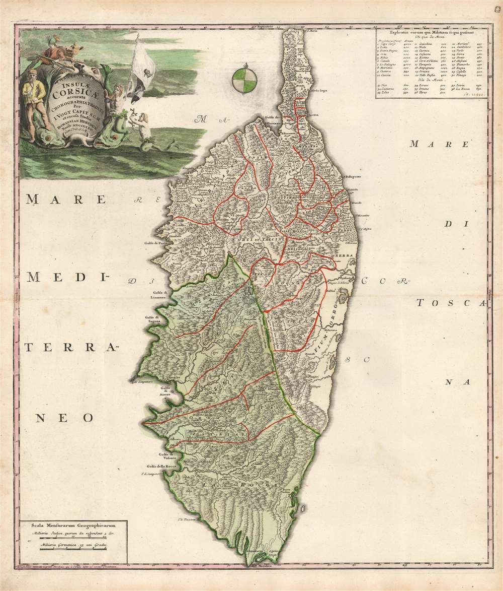
This is a 1735 Homann Heirs map of Corsica. The map's outline and detail are considerably advanced over maps of the island prior to 1734. It thus significantly represents the first major improvement in the mapping of Corsica since Jansson's 1644 map - which was the dominant model for throughout the 18th century. The firm of Homann Heirs themselves produced a map of Corsica in 1732 based on the Jansson model, making it all the more striking that they should update it with the present map so soon after.
A Mysterious Source
The map is credited in its cartouche to Johan Vogt, a captain in the army of the Holy Roman Emperor (Charles VI). Vogt is otherwise unknown, but the map was timely: in 1731, the emperor began sending troops to Corsica on the behest of its Genoese to put down a revolution. By 1732, twelve thousand Imperial troops were on the island fighting an unwinnable guerilla war against Corsican patriots. A treaty was negotiated in May 1732, in which the Genoese retained power but implemented reforms. Nonetheless, Genoa returned to the practices that inspired the initial revolt, resulting in a second explosion of violence shorly after. (This offered the German adventurer Theodor von Neuhoff the opportunity to successfully snatch kingship of Corsica until he was thrown in an Amsterdam debtors' prison.)A Closer Look
The map represents a fresh cartographic perspective on Corsica. The copious mountains depicted reflect the baffling prospect the island's terrain offered to both the cartographer and the professional army of which he was almost certainly part. It depicts the island in detail, labeling cities, towns, and villages, as well as rivers and mountain ranges. Text along the mountainous spine of the island notes, in German and Latin, that the plains atop the highest mountains are covered with great pine trees: a daunting prospect for any armies wishing to move unobserved. Several major cities are illustrated, including Bastia, Saint Florence, Rosoli, Bonifacio, and Porto Vecchio. Emphasizing the military source of this map, a table in the upper right enumerates, from each Corsican province, the number of men available for military service (an early manuscript hand gives a total of 22,990). The present map would be later credited in copies made by Ottens in 1737, in 1769 by the French mapmaker Robert de Vaugondy, and by the Spanish mapmaker Lopez. Ottens' map retained the military service table, but Vaugondy considered the information no longer relevant.The Cartouche
The map has a beautiful old color title cartouche - unusual in a Homann map. The design is an improved engraving of the same scene appearing on the earlier Homann Heirs map of the island. The title and source of the map are presented as if in the maw of a sea monster, which is flanked by two monstrous fish. To the left, a sailor with a plumb line stands with his foot on one fish's head; to the right, Neptune blows a shell horn while waving a flag bearing the 'Moor's head' arms of Corsica. A merman swims up to present the god of the sea with a tribute of red coral. Atop the sea monster, a musketeer sits with a ferocious wolf.Publication History and Census
We are aware of two states of this map: the first, printed in and around 1734, lacks the imperial privilege; the privilege appears on examples printed in and after 1735; ours is an example of this second state. Examples of the map appear in the Homann Heirs composite atlases. We see 27 examples of this state in institutional collections.CartographerS
Homann Heirs (1730 - 1848) were a map publishing house based in Nuremberg, Germany, in the middle to late 18th century. After the great mapmaker Johann Baptist Homann's (1664 - 1724) death, management of the firm passed to his son Johann Christoph Homann (1703 - 1730). J. C. Homann, perhaps realizing that he would not long survive his father, stipulated in his will that the company would be inherited by his two head managers, Johann Georg Ebersberger (1695 - 1760) and Johann Michael Franz (1700 - 1761), and that it would publish only under the name 'Homann Heirs'. This designation, in various forms (Homannsche Heirs, Heritiers de Homann, Lat Homannianos Herod, Homannschen Erben, etc..) appears on maps from about 1731 onwards. The firm continued to publish maps in ever diminishing quantities until the death of its last owner, Christoph Franz Fembo (1781 - 1848). More by this mapmaker...
Johann Vogt (fl. 1734) was a German officer and the only credited source for the first, contemporary 18th century mapping of the island of Corsica. Virtually nothing is known of him, apart from the map bearing his name, and a reference to a 1735 travelogue - 'Beschreibung der Insel Corsica' - which was apparently printed in Nuremberg and Altdorf, but has not survived in institutional collections. Its existence is hinted at only by a bibliographical reference in John Pinkerton's 1808 'A General Collection of the Best and Most Interesting Voyages and Travels in All Parts of the World.' We do not see any book of this title surviving in any institutional collection. Vogt's map appears first in 1734, printed by the firm of Homann Heirs. It was copied later by Ottens in 1737, and again in 1769 by the French mapmaker Vaugondy and the Spanish mapmaker Lopez. Vogt's title, 'Capit. S.C.M.' indicates that he was an officer of the Holy Roman Empire, and was most probably German; perhaps a military engineer accompanying the 12000 Imperial troops sent in 1732 to Corsica in order to put down the revolution which had broken out there. Learn More...
Source
Homann, J. B. and Homann, J. C., Neuer Atlas bestehend in einig curieusen Astronomischen Kuppren und vielen auserlesenen accuratensten Land-Charten über die Gantze Welt, (Nuremberg: Homann), 1728.
Homann's Neuer Atlas bestehend in einig curieusen Astronomischen Kuppren und vielen auserlesenen accuratensten Land-Charten über die Gantze Welt was first publihsed in 1707 with 33 maps. A second edition followed in 1710 with 60 maps. Subsequent editions followed until about 1730. The title page notes proudly that the atlas features measurements based on the 'Copernican principle of the moving sky', a truly state-of-the-art innovation for the period. Regardless of editions, collations of the atlas are inconsistent, with some examples having less, while others have more maps - a consequence of the fact that the map sheets were delivered loose, to be bound at the buyer's discretion, and so some buyers chose to omit maps they did not consider relevant, or add others they did. Between editions, the constituent maps, particularly of European regions, were regularly updated to reflect the most recent political events. The atlas continued to be published by Homann's son, J. C. Homann (1703 - 1730), and then by Homann Heirs. Most examples also feature a fine allegorical frontispiece with the title Atlas Novus Terrarum Orbis Imperia, regna et Status, which was used for multiple Homann atlases, including the Neuer Atlas and the Atlas Minor.
Condition
Very good. Light toning at extreme margins. Few minor spots, else excellent with beautifully executed original color.
References
OCLC 159899904. Rumsey 12499.091.