This item has been sold, but you can get on the Waitlist to be notified if another example becomes available, or purchase a digital scan.
1947 Cresp Bird's-Eye View Map of the Cote d'Azur (French Riviera), France
CotedAzur-cresp-1947$250.00


Title
La Côte d'Azur.
1947 (dated) 8.5 x 36.5 in (21.59 x 92.71 cm)
1947 (dated) 8.5 x 36.5 in (21.59 x 92.71 cm)
Description
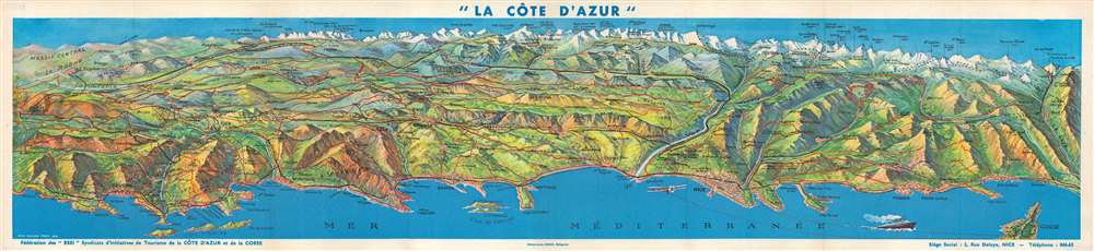
This is a stunning 1947 Jean-Honoré Cresp bird's-eye view map of the Côte d'Azur, the French Riviera. Overlooking the region from an imaginary perspective high above the Mediterranean, the most recognizable cities appear in the foreground along the coast, including Nice, St. Tropez, Cannes, Monte-Carlo, Toulon, and Monaco. Red lines highlight routes between sun-drenched playgrounds of the elite and stretch into a mountainous backdrop. Numerous mountain peaks are identified, with elevations noted. A line of small black 'x's mark the Franco-Italian border.
Publication History and Census
This map was drawn by Jean-Honoré Cresp and published by the Fédérations des 'ESSI' Syndicats d'Initiatives de Tourisme de la Côte d'Azur et de la Corse. At least two editions were published. One, an example of which is cataloged in the David Rumsey Map Collection, was published in 1930. A second edition, of which the present map is an example, was published in 1947. The 1947 edition is not cataloged in OCLC and is scarce on the private market.Condition
Very good. Exhibits light wear along original fold lines. Text printed on verso.
References
Rumsey 9981.000 (1930 edition). OCLC 638497984 (1930 edition).