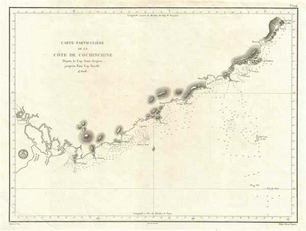
1830 Depot de la Marine Nautical Map or Chart of Vietnam Coast Depicting Saigon

CoteDeCochinchine-depot-1830
$500.00
Carte Particuliere de la Cote de Cochinchine Depuis le Cap Saint Jacques jusqu'an Faux Cap Varelle. - Main View
Processing...

1830 Depot de la Marine Nautical Map or Chart of Vietnam Coast Depicting Saigon

CoteDeCochinchine-depot-1830

Early French nautical chart of the southeast coast of Vietnam including Saigon.
$500.00

Title


Carte Particuliere de la Cote de Cochinchine Depuis le Cap Saint Jacques jusqu'an Faux Cap Varelle.
  1830 (undated)     18 x 24 in (45.72 x 60.96 cm)     1 : 525000

Description


This is an impressive c.1830 example of the French Depot-General de la Marine nautical chart or maritime map of the coast of Vietnam. It covers from Saigon (modern day Ho Chi Minh City) northward as far as Cam Ranh. Offers extraordinary detail both inland and at sea, noting rivers, elevations near the coast. Saigon city is identified. In the harbor there are countless depth soundings and other information important to the mariner. Issued by the Depot de Marine as chart no. 294.

Cartographer


Dépôt des Cartes et Plans de la Marine (fl. 1720 - present), often called the Dépôt de Marine, was a French hydrographic mapping organization founded in 1720 under Charles-Hercule of Albert de Luynes (1674 - 1734). Much like the U.S. Coast Survey, the British Admiralty, and the Spanish Deposito Hydrografico, the Dépôt was initiated as a storehouse and distribution center of existing nautical and marine charts. Eventually the Dépôt initiated its own mapping activities in an attempt to improve and expand upon existing material. Some of the more prominent cartographers and hydrographers associated with the of Dépôt des Cartes were, Philippe Buache, Jacques-Nicholas Bellin, Giovanni Rizzi-Zannoni, Rigobert Bonne, and Jean Nicolas Buache. More by this mapmaker...

Condition


Very good. Original platemark visible. Minor spotting at places.