This item has been sold, but you can get on the Waitlist to be notified if another example becomes available, or purchase a digital scan.
1786 Desnos and de la Tour Map of Brittany, France
CoteDuNordFinisterre-brion-1786$100.00

Title
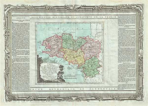
Carte des Departemens des Cotes du Nord, du Finisterre, de l'Ille et Vilaine, de la Loire inferieure et du Morbihan.
1790 (dated) 14.5 x 20.5 in (36.83 x 52.07 cm) 1 : 1300000
1790 (dated) 14.5 x 20.5 in (36.83 x 52.07 cm) 1 : 1300000
Description
This is a lovely map of the Bretagne region in France by the French cartographer Louis Brion de la Tour. It map covers the French departments of Finistere, Cotes-d'Amor, Ille-et-Vilaine, Morbihan, and Loire-Atlantique (previously known as Loire-Inferieure) in the Pays de la Loire region, all part of the former province of Brittany. Color coding divides the map according to region and notes numerous towns, cities, rivers, forests, mountains and other topographical features.
The map identifies the Island of Ouessant, the north-westernmost part of France. The western region of Brittany (department of Finistere) is known for its cider production and excellent boar hunting. The Ille-et-Vilaine region, in the northeast of Brittany, is famous for its seafood, and especially oysters. The region of Loire-Atlantique, located in the southeast, is part of the Loire Valley wine region, and is especially known for its production of Muscadet, a white wine produced from the Melon de Bourgogne grape variety. This area is also famous for a variety of cow's milk cheese known as Fromage du Cure Nantais. Morbihan is an exceptionally beautiful part of the Breton coast noted for its many islands, many of which are now privately owned by movie stars, politicians, well known musicians and other influential people. Morbihan is named for its most unusual feature, a large inland sea near Vannes, itself called The Morbihan. This region is also the home of the mysterious megalithic ruins at Carnac.
A beautifully engraved title cartouche adorns the bottom left quadrant of the map. To the left and right of the map are paste downs of French text with remarks and description of the map. Surrounding the whole is an elaborate decorative border featuring floral arrangements. This map was issued as plate no. 13 in Desnos’ Atlas National de France, bound with the most deluxe edition of his 1786 Atlas General Methodique et Elementaire, Pour l’Etude de la Geographie et de l’Histoire Moderne.
CartographerS
Louis Brion de la Tour (1743 - 1803) was the Cartographer Royal to the King of France, his official title being Ingenieur-Geographe du Roi. Despite a prolific cartographic career and several important atlases to his name, little is actually known of his life and career. He may have been born in Bordeaux. His son of the same name was born in 1763 and published until his death in 1832. It is nearly impossible to distinguish the work of the father from the work of the son, as both used the same imprint and were active in roughly the same period. Much of their work was published in partnership Louis Charles Desnos (fl. 1750 - 1790). Their most notable work is generally regarded to be his 1766 Atlas General. More by this mapmaker...
Louis Charles Desnos (1725 - April 18, 1805) was an important 18th century instrument maker, cartographer and globe maker based in Paris, France. Desnos was born in Pont-Sainte-Maxence, Oise, France, the son of a cloth merchant. From April of 1745 he apprenticed at a metal foundry. Desnos married the widow of Nicolas Hardy, sone of the map, globe, and instrument seller Jacques Hardy. Desnos held the coveted position of Royal Globemaker to the King of Denmark, Christian VII, for which he received a stipend of 500 Livres annually. In return Desnos sent the King roughly 200 Livres worth of maps, books and atlases each year. As a publisher, Desnos produced a substantial corpus of work and is often associated with Zannoni and Louis Brion de la Tour (1756-1823). Despite or perhaps because of the sheer quantity of maps Desnos published he acquired a poor reputation among serious cartographic experts, who considered him undiscerning and unscrupulous regarding what he would and would not publish. Desnos consequently had a long history of legal battles with other Parisian cartographers and publishers of the period. It is said that he published everything set before him without regard to accuracy, veracity, or copyright law. Desnos maintained offices on Rue St. Jacques, Paris. Learn More...
Source
Desnos, Louis-Charles, Atlas General Methodique et Elementaire, Pour l’Etude de la Geographie et de l’Histoire Moderne, 1786.
The Atlas general, civil, ecclesiastique et militaire, methodique et elementaire was issued by Louis Brion de la Tour (1756-1823) and Louis Charles Desnos (1725-1805) from about 1764 with subsequent reissued until about 1790. It was intended for use by the 'young nobles of the Ecole Royale Militaire,' but also proved popular with general audiences. The atlas was compiled using an uncommon printing method involving multiple pressings as well as paste downs for each page. Typically maps from the atlas feature an elaborate rococo decorative border containing a smaller map of approximately 10 x 14 inches, a title at the top and bottom of each page, and descriptive text, generally either a pastedown or separate printing to either side of the map. This unusual combination of printings and pastedowns allowed the publisher maximum flexibility and thus it is not uncommon to find variants of this atlas both with and without the decorative borer, with and without the descriptive pastedowns, pastedowns in different languages, and with changing titles for individual maps. There are various different collations for this atlas depending upon where it was intended to be sold. For example, versions sold in the United States and England replace the large map of France with new maps of the United States. It was not uncommonly bound with de la Tour's Atlas National de France.
Condition
Very good. Minor wear along original centerfold. Minor foxing.
References
OCLC: 956286299.