1960 Hoursch and Bechstedt Panorama Map of the Course of the Rhine River
CourseRhine-hoursch-1960$300.00

Title
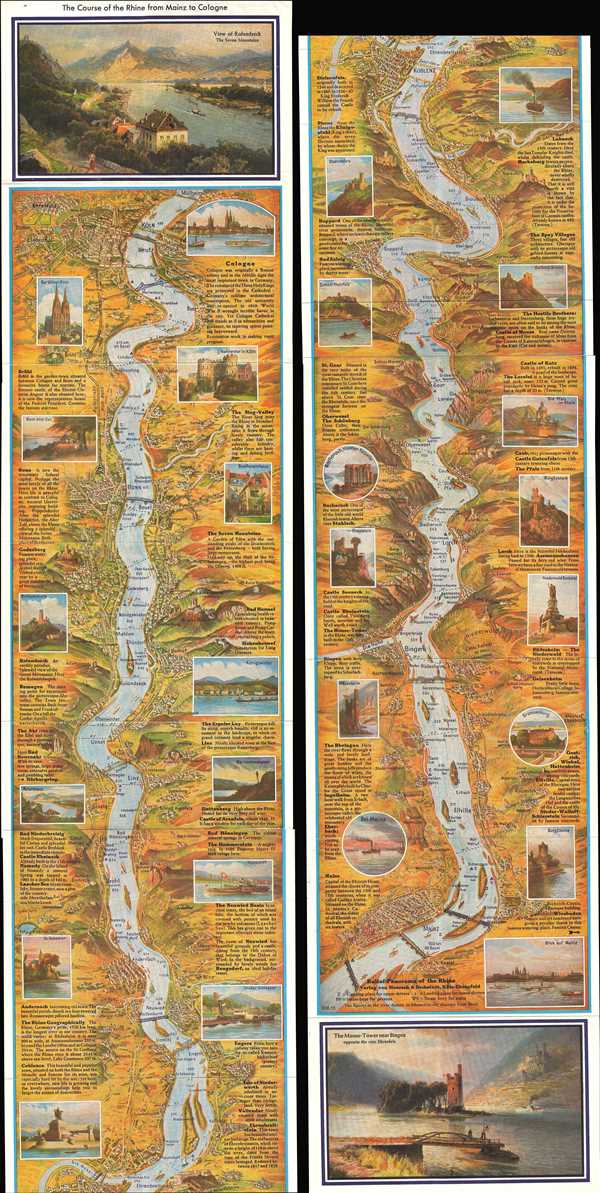
The Course of the Rhine from Mainz to Cologne.
1960 (undated) 60.5 x 7.25 in (153.67 x 18.415 cm)
1960 (undated) 60.5 x 7.25 in (153.67 x 18.415 cm)
Description
This is a 1960 Hoursch and Bechstedt bilingual panorama strip map of the course of the Rhine River. The map depicts the Rhine from Cologne, Germany to Mainz, Germany. Along the surprisingly straight course, numerous cities dot both banks. Information about these cities is included along both borders, as well as pictorial views of several landmarks along the way. The war, ostensibly World War II, is referred to several times, particularly destruction suffered by cities, including Cologne and Koblenz. The map also acknowledges, although does not depict, the Nürburgring, the world-famous motorsport complex. The reality of a divided Germany also appears here, in the statement that Bonn 'is not the temporary federal capital.' In many ways, it appears that this map was issued for English speaking tourists and servicemen who were in Germany. Popular tourism activities, such as wineries and ruins, are highlighted throughout, and dominate the included views. At each end of the map a large view is included. At the top lies a View of Rolandseck and at the bottom the Mouse Tower new Bingen.
This map was published by Hoursch and Bechstedt in Cologne-Ehrenfeld in 1960.
This map was published by Hoursch and Bechstedt in Cologne-Ehrenfeld in 1960.
Condition
Very good. One long strip map. Attached to original booklet. Blank on verso.
References
OCLC 929075731.