This item has been sold, but you can get on the Waitlist to be notified if another example becomes available, or purchase a digital scan.
1749 Vaugondy Map of the Mississippi River and Louisiana
CoursMississippi-vaugondy-1749$175.00

Title
Cours du Mississipi et la Louisiane. Par le Sr. Robert de Vaugondy, fils de Mr. Robert Géog. Du Roi.
1749 (dated) 9 x 7 in (22.86 x 17.78 cm) 1 : 9600000
1749 (dated) 9 x 7 in (22.86 x 17.78 cm) 1 : 9600000
Description
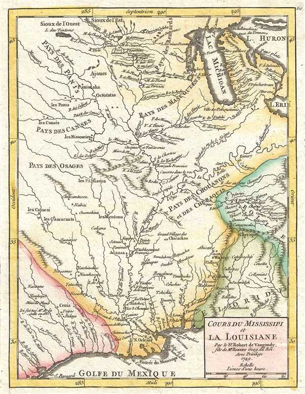
This is a hand colored 1749 Didier Robert de Vaugondy map of the Mississippi River and Louisiana. Issued just before the French and Indian War (1754 – 1763), this map focuses on the Mississippi River, depicting from north of Lake Michigan at the top of the map south to the mouth of the Mississippi in the Gulf of Mexico in Louisiana at the bottom and from Pays des Canses and the Pays des Osages east to the Carolinas, Florida, and Lake Erie. The map presents the Mississippi River system in detail, depicting the many tributaries and confluences along its course, including the Missouri River. French forts and merchant establishments are noted throughout in an attempt to express political, settlement, and mercantile activity in the region and thereby assert land claims. Lakes Michigan, Huron, and Erie are depicted in the upper-right corner. Most of the country depicted in the map is labeled using Native American tribes, such as the Pawnee (Panis), the Cherokee (Cheraquis) and the Osage. New Orleans is labeled in Louisiana as well as Lake Pontchartrain (L. Ponchartrain). The border between Spanish-held Texans and French-held Louisiana is easily recognizable.
This map was published by Gilles Robert de Vaugondy in his Atlas Universel, Portatif et Militaire in the 1749 edition.
This map was published by Gilles Robert de Vaugondy in his Atlas Universel, Portatif et Militaire in the 1749 edition.
Cartographer
Robert de Vaugondy (fl. c. 1716 - 1786) was French may publishing from run by brothers Gilles (1688 - 1766) and Didier (c. 1723 - 1786) Robert de Vaugondy. They were map publishers, engravers, and cartographers active in Paris during the mid-18th century. The father and son team were the inheritors to the important Nicolas Sanson (1600 - 1667) cartographic firm whose stock supplied much of their initial material. Graduating from Sanson's maps, Gilles, and more particularly Didier, began to produce their own substantial corpus. The Vaugondys were well-respected for the detail and accuracy of their maps, for which they capitalized on the resources of 18th-century Paris to compile the most accurate and fantasy-free maps possible. The Vaugondys compiled each map based on their own geographic knowledge, scholarly research, journals of contemporary explorers and missionaries, and direct astronomical observation. Moreover, unlike many cartographers of this period, they took pains to reference their sources. Nevertheless, even in 18th-century Paris, geographical knowledge was limited - especially regarding those unexplored portions of the world, including the poles, the Pacific Northwest of America, and the interiors of Africa, Australia, and South America. In these areas, the Vaugondys, like their rivals De L'Isle and Buache, must be considered speculative or positivist geographers. Speculative geography was a genre of mapmaking that evolved in Europe, particularly Paris, in the middle to late 18th century. Cartographers in this genre would fill in unknown lands with theories based on their knowledge of cartography, personal geographical theories, and often dubious primary source material gathered by explorers. This approach, which attempted to use the known to validate the unknown, naturally engendered rivalries. Vaugondy's feuds with other cartographers, most specifically Phillipe Buache, resulted in numerous conflicting papers presented before the Academie des Sciences, of which both were members. The era of speculative cartography effectively ended with the late 18th-century explorations of Captain Cook, Jean Francois de Galaup de La Perouse, and George Vancouver. After Didier died, his maps were acquired by Jean-Baptiste Fortin, who in 1787 sold them to Charles-François Delamarche (1740 - 1817). While Delamarche prospered from the Vaugondy maps, he defrauded Vaugondy's window Marie Louise Rosalie Dangy of her rightful inheritance and may even have killed her. More by this mapmaker...
Source
Robert de Vaugondy, G., Atlas Portatif, Universel, et Militaire, (Paris: Vaugondy, Durand, Pissot) 1749.
Condition
Very good. Blank on verso. Original press mark visible.
References
Pedley, M. S., Bel et Utile, p. 214, #470.