
This item below is out of stock, but another example (left) is available. To view the available item, click "Details."
Details
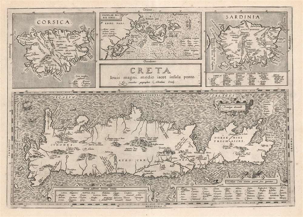
1603 Ortelius Map of Crete w/ Greek Islands (Vrients Edition)
1584 (undated) $1,200.00
1584 Ortelius Map of Crete and an array of Greek Islands
CretaLouisMagni-ortelius-1584-2$600.00

Title
Creta Jovis Magni Medio Iacet Insula Ponto.
1584 (undated) 13.25 x 19 in (33.655 x 48.26 cm) 1 : 600000
1584 (undated) 13.25 x 19 in (33.655 x 48.26 cm) 1 : 600000
Description
This is Abraham Ortelius' 1595 map of Crete and other Mediterranean islands as they were understood in antiquity and Greek mythology. The engraving is comprised of four separate maps of Corsica, Sardinia, Crete, and the Ionian Islands.
Ortelius: Scholar of Antiquity
It is among the maps Ortelius prepared for the volume of his atlas dedicated to ancient and Biblical geography, the Parergon. Although Ortelius is better known as a compiler of other geographers' maps, he was a scholar of Antiquity in his own right and many of the maps of Parergon were his own unique compositions, albeit drawing on classical textual sources such as Pliny, Strabo, Seneca, and Livy. The four maps are beautifully and distinctively engraved, some with stippled water and others (notably the Crete map) with vigorous waves. Mountains are indicated pictorially, with again those of Crete shown most evocatively. Important locations, such as the Labyrinth of the Minotaur, are marked. Lists, of cities and locations whose names were known but whose locations were not, are included on each map.Publication History and Census
This map was engraved for inclusion in the 1584 edition of Orbis Theatrum Terrarum. This specific example corresponds typographically to the 1595 Latin edition of the work. We see perhaps ten examples of this separate map in institutional collections, although poor transcription in the recording of this map (Jovis? Iovis? Louis?) makes an accurate count difficult.Cartographer
Abraham Ortelius (April 14, 1527 - June 28, 1598) also known as Ortels, was a cartographer, geographer, and cosmographer of Brabant, active in Antwerp. He was the creator of the first modern atlas, Theatrum Orbis Terrarum and is a seminal figure in the history of cartography. Along with Gerard Mercator and Gemma Frisius, he was a founder of the Netherlandish school of cartography. His connections with Spain - culminating in his 1575 appointment as Royal Cartographer to King Phillip II of Spain - gave him unmatched access to Spanish geographical knowledge during a crucial period of the Age of Discovery. Ortelius was born in 1527 in Antwerp. In 1547 he entered the Antwerp Guild of Saint Luke as an illuminator of maps. He began trading in books, prints, and maps, traveling regularly to the Frankfurt book and print fair, where in 1554 he met Mercator. He accompanied Mercator on journeys throughout France in 1560 and it was at this time, under Mercator's influence, that he appears to have chosen his career as a scientific geographer. His first published geographic work appeared in 1564, an eight-sheet cordiform world map. A handful of other maps preceded the 1570 publication of the first edition of the Theatrum Orbis Terrarum, which would prove to be his life work. Appearing with but 53 maps in its first edition, Ortelius' work expanded with new maps added regularly. By 1592, it had 134 maps. Many of Ortelius' maps remained the standard for nearly a century. He traveled extensively, but his genius was as a compiler, locating the best informed maps on which to base his own. His contacts throughout Europe and extending even (via the Portuguese) to the Far East were formidable. Moreover, many of his maps were based on his own scholarship, particularly his historical works. His theories of geography were particularly ahead of his time with respect to the notion of continental drift, the possibility of which he mused on as early as 1596, and which would be proven correct centuries later.
In a sense his greatest achievement was his successful navigation of the religious and political violence endemic to his city throughout his adult life: The Dutch Revolt, or Eighty Years' War (1568 - 1648), fully embroiled Antwerp. Although outwardly and officially recognized as Catholic (Arias Montanus vouched for Ortelius' Catholic orthodoxy prior to his appointment as Royal Geographer), Ortelius was able to separate himself from the religious furor which characterized the war in the low countries. Ortelius showed a glimpse of himself in a letter to a friend, regarding humanist Justus Lipsius: 'I do not know whether he is an adherent of the Pope or a Calvinist, but if he has ears to hear, he will neither be one nor the other, for sins are committed on both sides'. Ortelius' own explorations of Biblical history in his maps, and the Christogram contained in his own motto, suggest him to be a religious man, but his abjuration of political religious authorities mark him as an individualist. His tombstone at St Michael's Præmonstratensian Abbey in Antwerp bears the inscription, Quietis cultor sine lite, uxore, prole. ('served quietly, without accusation, wife, and offspring.') More by this mapmaker...
Source
Ortelius, A., Theatrum Orbis Terrarum, (Antwerp: Ortelius) 1595.
Condition
Excellent. Generous margins, with a bold strike.
References
OCLC 551932248. van den Broecke, M., Ortelius Atlas Maps, #217. Van der Krogt, P. C. J., Koeman's Atlantes Neerlandici, (3 Vols), #7900H:31. Zakharakis, C. G., A Catalogue of Printed Maps of Greece 1477-1800, #2504.