This item has been sold, but you can get on the Waitlist to be notified if another example becomes available, or purchase a digital scan.
1696 Coronelli Map of the Kingdom of Crete
Crete-coronelli-1696$2,000.00

Title
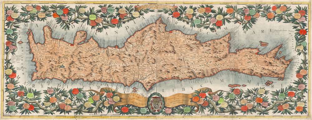
Isola e regno di Candia.
1696 (undated) 13.75 x 47 in (34.925 x 119.38 cm) 1 : 409700
1696 (undated) 13.75 x 47 in (34.925 x 119.38 cm) 1 : 409700
Description
This is a brilliantly-colored example of Vincenzo Coronelli's monumental, two-sheet 1696 map of the Island and Kingdom of Crete. It divides the island into the four regions of Canea, Rettimo, Candia, and Setia.
A Closer Look
It is derived from the surveys of the Venetian engineer Francesco Basilicata (d. 1640). In spite of being otherwise virtually unknown, Basilicata's maps of Crete provided the most accurate outline of the island of the 17th century and would provide the basis not only for Coronelli's masterful work but well into the 18th century. Basilicata is believed to have lived in Crete in the early 17th century during the Venetian colonial tenure of the island, and so the map benefits from firsthand experience. This map's visually arresting presentation is owed to the bravura work of Coronelli's shop, whose mastery of the engraver's art shows not only in the map's pictorially represented topography but also in the map's border of medallions, naming Cretan towns, framed as the fruit adorning intertwining branches. The map's title cartouche includes a dedication to the French diplomat and cardinal César d'Estrées (1628 - 1714.)Publication History and Census
The two plates of this map were engraved for inclusion in Coronelli's Corso Geografico Universale, and would be reprinted in his 1696 Isolario descrittione geografico-historia... Tomo II dell' Atlante Veneto. The map appears on the market from time to time We see only six separate examples cataloged in institutional collections.Cartographer
Vincenzo Maria Coronelli (August 16, 1650 - December 9, 1718) was an important 17th-century cartographer and globe maker based in Venice. Coronelli was born the fifth child of a Venetian tailor. Unlikely to inherit his father's business, he instead apprenticed in Ravenna to a woodcut artist. Around 1663, Coronelli joined the Franciscan Order and, in 1671, entered the Venetian convent of Saint Maria Gloriosa dei Frari. Coronelli excelled in the fields of cosmography, mathematics, and geography. Although his works include the phenomenal Atlante Veneto and Corso Geografico, Coronelli is best known for his globes. In 1678, Coronelli was commissioned to make his first major globes by Ranuccio II Farnese, Duke of Parma. Each superbly engraved globe was five feet in diameter. Louis IV of France, having heard of the magnificent Parma globes, invited Coronelli to Paris, where from 1681-83 he constructed an even more impressive pair of globes measuring over 12 feet in diameter and weighing 2 tons each. The globes earned him the patronage of Louis XIV and privileged access to French cartographic information from Jesuit sources in the New World, particularly Louisiana. Coronelli returned to Venice and continued to publish globes, maps, and atlases, which were admired all over Europe for their beauty, accuracy, and detail. He had a particular fascination for the Great Lakes region, and his early maps of this area were unsurpassed in accuracy for nearly 100 years after their initial publication. He is also well known for his groundbreaking publication of the first accurate map depicting the sources of the Blue Nile. At the height of his career, Coronelli founded the world's first geographical society, the Accademia Cosmografica degli Argonauti, and was awarded the official title Cosmographer of the Republic of Venice. In 1699, in recognition of his extraordinary accomplishment and scholarship, Coronelli was also appointed Father General of the Franciscan Order. The great cartographer and globe maker died in Venice at the age of 68. His extraordinary globes can be seen today at the Bibliothèque Nationale François Mitterrand in Paris, Biblioteca Marciana in Venice, the National Library of Austria, the Globe Museum in Vienna, the Library of Stift Melk, the Special Collections Library of Texas Tech University, as well as lesser works in Trier, Prague, London, and Washington D.C. Coronelli's work is notable for its distinctive style, which is characterized by the high-quality white paper, dark intense impressions, detailed renderings of topographical features in profile, and numerous cartographic innovations. More by this mapmaker...
Source
Coronelli, V., Isolario dell' Atlante Veneto, (Venice: A spese dell' Autore) 1697.
The Isolario dell' Atlante Veneto, also titled Isolario Descrittione Geografico-Historia, is the second part of the Jesuit Minorite friar, geographer, and globe maker Vincenzo Maria Coronelli's multi-volume Atlante Veneto. The Isolario was compiled in Venice and published in 1696-97. The work consists of two parts which, as the title suggests, focus primarily on islands. The first part covers the Mediterranean, Italy, and the Adriatic, while the second part details Britain and Europe, Africa, Japan and Asia, and the West Indies. Like some of his other works, Coronelli published the Isolario 'A spese dell' Autore' [At the Expense of the Author].
Condition
Very good. Two printed sheets, joined. Two surface mends with no loss. Fine hand color.
References
OCLC 1192398776. Zacharakis, C. G., A Catalogue of Printed Maps of Greece 1477 - 1800, #1097.