This item has been sold, but you can get on the Waitlist to be notified if another example becomes available, or purchase a digital scan.
1513 Waldseemüller Map of Crete - the First Printed Map of the Island
Crete-waldseemuller-1513$2,250.00

Title
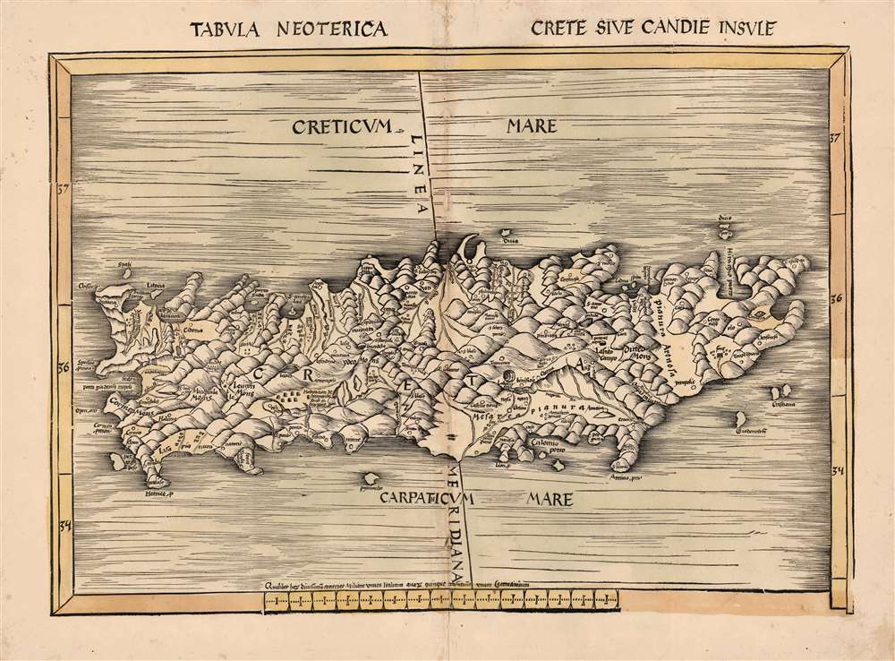
Tabula Neoterica Crete Sive Candie Insule.
1513 (undated) 15.25 x 20.75 in (38.735 x 52.705 cm) 1 : 930000
1513 (undated) 15.25 x 20.75 in (38.735 x 52.705 cm) 1 : 930000
Description
This is Martin Waldseemüller's 1513 map of the island of Crete - the first specific map of the island, and the first detailed depiction of the island not strictly based on the precedent of Claudius Ptolemy. Crete was of course depicted among the other Greek islands on printed Ptolemaic maps as early as 1477. But, this map, appearing among the modern maps added to Waldseemüller and Ringmann's 1513 Geographia, was the first map dedicated entirely to the island.
Among other notable and tantalizing features are colonies of cave-dwellings, yet another sign that the map was at least in part the result of actual visitation: such dwellings remain extant on the island, and are a known part of its history.
Primacy
The Ptolemaic map of the Greek islands that appears in that 1513 work, Decima et ultima tabula Europae, includes a Crete that in no way resembles the one presented here. Not only are there fewer details, but also those details that appear sharply differ. While many of the sources for Tabula Neoterica Crete Sive Candie Insule are no doubt classical, they are not Ptolemaic. Pliny the Elder and Strabo both discussed the island in detail in their first-century writings. Several geographical notations on the Waldseemüller - for example the 'Plannura Arenosa' and the 'Mesarea Plannura' - are not in Latin, but in Portuguese or Spanish, suggesting that Waldseemüller's classical sources were supplemented by contemporaneous charts secreted from the Iberian Peninsula, much as was the case with his maps of the New World.The Labyrinth and Other Holes in the Ground
Among the features appearing here for the first time is a symbol representing the Labyrinth of Daedalus: the legendary maze built for King Minos to contain the bull-headed Minotaur. While often considered to have been constructed at Knossos, recent archaeology suggests a series of tunnels at Gortyn, which is tantalizingly close to the location of the labyrinth symbol on the Waldseemüller map. This would correspond with Gortyna, the Cretan capital in the 1st century AD. Waldseemuller's source for this was likely Pliny the Elder's Naturalis Historia. Other archaeological sites of interest appear. Crete's Lassithi Plateau is shown (Lasuto Campo) marking the site of the Psychro Cave as well as the Dikti mountains nearby. Greek Mythology identifies this as the birthplace of Zeus, and was said to be the divine lecher's hiding place after his abduction of Europa.Among other notable and tantalizing features are colonies of cave-dwellings, yet another sign that the map was at least in part the result of actual visitation: such dwellings remain extant on the island, and are a known part of its history.
A Key Prototype Map
This map was sufficiently authoritative to make it the prototype for all maps of the island for the first half of the 16th century. Sebastian Münster printed a much-simplified version of this map in his Cosmographia. Ortelius' Theatrum included a map faithfully based on this model (possibly via Camocio, who also copied Waldseemuller) until it was replaced in 1584 by one based on the 1563 work of an actual Cretan, Giorgio Sideri Calapoda (fl. c. 1537 - 1565).A New Ptolemy
This map appeared in the 1513 edition of Claudius Ptolemy's Geographia, whose translation and maps were the collaboration of Martin Waldseemüller and Matthias Ringmann, who are best known for their 1507 world map, the monumental Universalis Cosmographia. Starting with the maps printed in the 1482 Ulm Ptolemy, Waldseemüller and Ringmann consulted a variety of Greek and Latin manuscript copies of Ptolemy in order to produce an authoritative, corrected edition of the classical proto-atlas. In addition to the twenty-seven maps based strictly on Ptolemy's data, it included twenty Tabulae Modernae. Among these maps are the first printed maps to focus on regions unknown to Ptolemy such as North America and southern Africa, but they also include maps of areas covered in Ptolemaic geography but with new topography and toponymy based on contemporaneous information, such as the maps of Lorraine and the upper Rhine (which Waldseemüller probably surveyed himself) and this map of Crete. Ironically, Waldseemüller's name did not appear in the published book, as he and Ringmann had had a falling outand by 1513 the two were no longer working together.Publication History and Census
This map was drawn between 1507 and 1513 by Martin Waldseemüller as part of his work with the Gymnasium Vosagense, an association of humanist scholars formed in Saint-Dié under the patronage of the Duke of Lorraine. The map was included in the Gymnasium's 'Geographie Opus Novissima Traductione E Graecorum Archetypis,' printed in 1513 by Johannes Schott in Strasbourg. Schott published a single further edition of the book in 1520; there were no alterations to the blocks. Five examples - three dated 1513, two dated 1520, none with any clear explanation for this dating - are cataloged in OCLC.Cartographer
Martin Waldseemüller (September 11, 1470 - March 16, 1520) was a German cartographer, astronomer, and mathematician credited with creating, along with Matthias Ringmann, the first map to use the placename America. He was born in Wolfenweiler, near Freiburg im Breisgau. Waldseemüller studied at the University of Freiburg and, on April 25, 1507, became a member of the Gymnasium Vosagese at Saint-Dié. Martin Waldseemüller was a major proponent of theoretical or additive cartography. Unlike contemporary Portuguese and Spanish cartographers, who left maps blank where knowledge was lacking, Waldseemüller and his peers speculated based upon geographical theories to fill unknown parts of the map. He is best known for his Universalis Cosmographia a massive 12-part wall map of the world considered the first map to contain the name America, today dubbed as 'America's Birth Certificate'. This map also had significance on other levels, as it combined two previously unassociated geographical styles: Ptolemaic Cartography, based on an ancient Greek model, and the emergent 'carta marina', a type of map commonly used by European mariners in the late 15th and 16th centuries. It also extended the traditional Ptolemaic model westward to include the newly discovered continent of America, which Waldseemüller named after the person he considered most influential in its discovery, Amerigo Vespucci. When Waldseemüller died in 1520, he was a canon of the collegiate Church of Saint-Dié. In contemporary references his name is often Latinized as Martinus Ilacomylus, Ilacomilus, or Hylacomylus. More by this mapmaker...
Source
Waldseemüller, M. / Ringmann, M., Geographie Opus Novissima Traductione E Graecorum Archetypis, (Strasbourg: Schott) 1513.
Condition
Very good. Few typical filled threadholes at centerfold, old wash color, else excellent with a bold strike.
References
OCLC 165585744. Zacharakis, C. G., A Catalogue of Printed Maps of Greece 1477-1800, #2782.