This item has been sold, but you can get on the Waitlist to be notified if another example becomes available, or purchase a digital scan.
1856 Desilver Map of the Crimean Peninsula, Crimea
Crimea-desilver-1856$100.00

Title
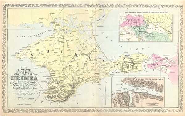
A Complete Map of the Crimea Showing the Military and Carriage Roads with Distances from Various Points of the Western Coast.
1856 (dated) 16.5 x 27 in (41.91 x 68.58 cm) 1 : 660000
1856 (dated) 16.5 x 27 in (41.91 x 68.58 cm) 1 : 660000
Description
This is a scarce map of the Crimean Peninsula by little known American map publisher Charles Desilver. It depicts the Crimean Peninsula during the Crimean War. This highly detailed map notes military and carriage roads throughout with distances. Towns, fortifications, lighthouses, postal stations, as well as topography are shown. An inset in the top right quadrant features the relative position of Crimea with the seat of war. Another inset in the lower right quadrant features the Sebastopol Harbor.
Sebastopol's place in history was cemented during the Crimean War. Seeking to punish Russia for its imperialistic designs on the Balkans Napoleon III and his allies, the English and Turks, invaded the peninsula, quickly taking Balaklava. The high point of the war was the legendary and disastrous 'Charge of the Light Brigade' wherein an entire British Calvary unit charged to its death against a fortified Russian position.
The plate was originally published by Samuel Augustus Mitchell, who sold the copyright to Thomas, Cowperthwait and Company in 1850. Charles Desilver in turn bought them in 1856. This map was issued in the 1856 edition of Desilver’s New Universal Atlas.
Cartographer
Charles Desilver (1815 - May 18, 1876) was an American book and map publisher active during the 19th century in Philadelphia. Desilver, the son of Thomas Desilver of the firm Desilver, Thomas and Co., began is cartographic career as a partner in the firm Thomas, Cowperthwait and Company, the publisher of Samuel Augustus Mitchell's popular New Universal Atlas. Thomas, Cowperthwait and Company was succeeded by Cowperthwait, Desilver and Butler. In 1856, when the previous firm dissolved, Desilver succeeded it by starting his own lithographic firm, acquired Mitchell's copyrights, and began publishing his own variant on the New Universal Atlas. Desilver revised Mitchell's maps with a new grillwork border, his own color scheme, new titles, and some updated political data. Despite a noble pedigree, Desilver's maps did not sell well - possibly because they followed the long and very popular run of Mitchell's own atlases. Desliver continued to publish his atlas until 1859 (though we have heard that he also published an 1862 edition). In 1859 he resold the Mitchell copyrights and printing plates to S. A. Mitchell's son S. A. Mitchell, Jr. The younger Mitchell again updated the plates with his own border and color scheme. He began publishing his own successful atlas in 1860. Desilver continued to operate his firm even after selling the Mitchell copyrights, and his sons Harry and Joseph T., joined the firm in 1875 which was renamed Desilver and Sons. Desilver married Caroline Hill on March 29, 1836, in Philadelphia, with whom he had several children. More by this mapmaker...
Source
Desilver C., A New Universal Atlas Containing Maps of the various Empires, Kingdoms, States and Republics Of The World (Philadelphia), 1856.
Condition
Very good. Minor wear and toning along original centerfold. Minor foxing.
References
Rumsey 2514.060.