
This item below is out of stock, but another example (left) is available. To view the available item, click "Details."
Details
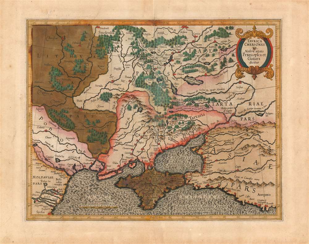
1595 Mercator Map of the North Black Sea Coast
$900.00
1595 Mercator Map of the Black Sea Coast of Russia
Crimea-mercator-1595$425.00

Title
Taurica Chersonesus. Nostra aetate Przecopsca et Gazara dicitur.
1595 (undated) 12.25 x 15.5 in (31.115 x 39.37 cm) 1 : 3600000
1595 (undated) 12.25 x 15.5 in (31.115 x 39.37 cm) 1 : 3600000
Description
This is the 1595 first state of Mercator's map of the Crimea, still known to geographers by its Ptolemaic name of Taurica Chersonesus. The engraving is bold and sharp - a product of the youth of the copperplate - and the rich hand color has aged to an attractive patina. Many recognizable place names can be found on this detailed map, including Moscow, Smolensk, Kiev, and Chernobyl. The primary focus of this map, however, is Russia’s extremely fluid southeastern border with the Crimean Tatars. The border garrisons of Ryazan (Rezan on the map) and the Crimea suffered yearly assaults from the steppes. Moscow’s response – the annual raising of an army of tens of thousands to patrol this border – was instrumental in developing the centralized power of the Tsar in the 16th and 17th centuries.
Publication History and Census
This map was engraved by Gerard Mercator and included by his heirs in the first editions of that geographer's atlas. The plate was acquired by Jodocus Hondius along with the rest, and it appeared in the Hondius atlas until the plate was replaced by a new map in 1636. This edition appears separately in only seven institutional collections; later issues are more common.Cartographer
Gerard Mercator (March 5, 1512 - December 2, 1594) is a seminal figure in the history of cartography. Mercator was born near Antwerp as Gerard de Cremere in Rupelmonde. He studied Latin, mathematics, and religion in Rupelmonde before his Uncle, Gisbert, a priest, arranged for him to be sent to Hertogenbosch to study under the Brothers of the Common Life. There he was taught by the celebrated Dutch humanist Georgius Macropedius (Joris van Lanckvelt; April 1487 - July 1558). It was there that he changed him name, adapting the Latin term for 'Merchant', that is 'Mercator'. He went on to study at the University of Louvain. After some time, he left Louvain to travel extensively, but returned in 1534 to study mathematics under Gemma Frisius (1508 - 1555). He produced his first world map in 1538 - notable as being the first to represent North America stretching from the Arctic to the southern polar regions. This impressive work earned him the patronage of the Emperor Charles V, for whom along with Van der Heyden and Gemma Frisius, he constructed a terrestrial globe. He then produced an important 1541 globe - the first to offer rhumb lines. Despite growing fame and imperial patronage, Mercator was accused of heresy and in 1552. His accusations were partially due to his Protestant faith, and partly due to his travels, which aroused suspicion. After being released from prison with the support of the University of Louvain, he resumed his cartographic work. It was during this period that he became a close fried to English polymath John Dee (1527 - 1609), who arrived in Louvain in 1548, and with whom Mercator maintained a lifelong correspondence. In 1552, Mercator set himself up as a cartographer in Duisburg and began work on his revised edition of Ptolemy's Geographia. He also taught mathematics in Duisburg from 1559 to 1562. In 1564, he became the Court Cosmographer to Duke Wilhelm of Cleve. During this period, he began to perfect the novel projection for which he is best remembered. The 'Mercator Projection' was first used in 1569 for a massive world map on 18 sheets. On May 5, 1590 Mercator had a stroke which left him paralyzed on his left side. He slowly recovered but suffered frustration at his inability to continue making maps. By 1592, he recovered enough that he was able to work again but by that time he was losing his vision. He had a second stroke near the end of 1593, after which he briefly lost speech. He recovered some power of speech before a third stroke marked his end. Following Mercator's death his descendants, particularly his youngest son Rumold (1541 - December 31, 1599) completed many of his maps and in 1595, published his Atlas. Nonetheless, lacking their father's drive and genius, the firm but languished under heavy competition from Abraham Ortelius. It was not until Mercator's plates were purchased and republished (Mercator / Hondius) by Henricus Hondius II (1597 - 1651) and Jan Jansson (1588 - 1664) that his position as the preeminent cartographer of the age was re-established. More by this mapmaker...
Source
Mercator, G. Mercator's Atlas sive cosmographicae meditationes de fabrica mundi et fabricati figura. (Amsterdam) 1595 - 1602.
Mercator's Atlas is one of the most important works in the history of cartography. Although in fact Ortelius was the first to publish a proper atlas, the Teatrum Orbis Terrarum, Mercator's work the first book to employ the term Atlas for a collection of maps. The term is derived both from the mythical titan, Atlas, who was forced to bear the world upon his shoulders, and the Libyan king, philosopher, and astronomer of the same name that, so the legend goes, constructed the first globe. Mercator dedicated the final 25 years of his life to compile the Atlas. He published two parts during his lifetime in 1585 and 1589, but the final part published posthumously by his son Rumold Mercator, in 1595. The map plates for the Atlas were later acquired by Jodocus Hondius who published the most complete and well known edition in 1606. It was Jodocus who popularized the Atlas and who did the most to elevate Gerard Mercator's name.
Condition
Very good condition. Lightly toned, with areas of oxidation. Else excellent condition with original hand color and an attractive patina.
References
OCLC 38904725. Van der Krogt, P. C. J., Koeman's Atlantes Neerlandici, (3 Vols), 1890:1 A.1.