1854 Philip Map of the Crimean Peninsula / Crimea
Crimea-philip-1854$300.00

Title
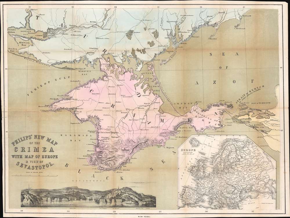
Philips' New Map of the Crimea with Map of Europe and View of Sevastopol.
1854 (undated) 20.25 x 27 in (51.435 x 68.58 cm) 1 : 760320
1854 (undated) 20.25 x 27 in (51.435 x 68.58 cm) 1 : 760320
Description
This is a striking 1854 George Philip map of the Crimean Peninsula (Crimea) during the Crimean War. Coverage extends from the Dnieper River to the Black Sea, and from Tendra Bay to the Sea of Azov. Text near Kalamita Bay follows the action of the Crimean War. A notation marks where the Allies landed on September 14, and another indicates the site of the Battle of the Alma and Allied and Russian positions. Sevastopol, the Allied objective, is identified at the bottom of Kalamita Bay. A view of Sevastopol is situated along the bottom border. Within the view, three forts, the cemetery, and a lighthouse are named. An inset map of Europe in the bottom right situates Crimea in relation to continental Europe.
Hostilities erupted in July 1853 when Russia invaded two Ottoman suzerainties known collectively as the Danubian Principalities: Wallachia and Moldavia. The Ottomans immediately responded and fought a defensive campaign that eventually halted the Russian advance at Silistra, which the Russians besieged. Alarmed by the possibility of an Ottoman collapse, the British and French jumped to their aid, sending troops and supplies to Gallipoli. They did not arrive at Silistra until after the Russians had withdrawn.
At this point, public opinion at home, where discontent aroused by the wasted effort and expense of sending armies to the Balkans, exerted an influence on the alliance. This outcry led to the planning and execution of an invasion of the Crimean Peninsula and a siege of the Russian naval port of Sevastopol, their primary naval base in the Black Sea. The siege lasted eleven months. Russia finally sued for peace in March 1856. In the Treaty of Paris that ended the war Russia lost its Black Sea ports, Wallachia and Moldavia gained a modicum of independence, and Christians in the Holy Land were given a degree of equality.
The Crimean War
The Crimean War, with an alliance of the Ottoman Empire, Britain, France, and Sardinia on one side of the conflict and the Russian Empire on the other, lasted from October 1853 until February 1856. The root cause of the war has never been fully understood, but the stated impetus for hostilities was the rights of Christians in the Holy Land, with the Catholics being supported by the French and the Greek Orthodox Church gaining the support of the Russians. Other factors also included the gradual decline of the Ottoman Empire and British and French concerns about Russian gains in the region at the cost of the Ottomans.Hostilities erupted in July 1853 when Russia invaded two Ottoman suzerainties known collectively as the Danubian Principalities: Wallachia and Moldavia. The Ottomans immediately responded and fought a defensive campaign that eventually halted the Russian advance at Silistra, which the Russians besieged. Alarmed by the possibility of an Ottoman collapse, the British and French jumped to their aid, sending troops and supplies to Gallipoli. They did not arrive at Silistra until after the Russians had withdrawn.
At this point, public opinion at home, where discontent aroused by the wasted effort and expense of sending armies to the Balkans, exerted an influence on the alliance. This outcry led to the planning and execution of an invasion of the Crimean Peninsula and a siege of the Russian naval port of Sevastopol, their primary naval base in the Black Sea. The siege lasted eleven months. Russia finally sued for peace in March 1856. In the Treaty of Paris that ended the war Russia lost its Black Sea ports, Wallachia and Moldavia gained a modicum of independence, and Christians in the Holy Land were given a degree of equality.
Publication History and Census
This map was created and published by George Philip in 1854. We note a single example cataloged in OCLC which is part of the collection at the National Library of Scotland.Cartographer
George Philip (1800 - 1882) was a map publisher and cartographer active in the mid to late-19th century. Philip was born into a Calvinst family in Huntly, Aberdeenshire, Scotland. Around 1819 he apprenticed himself to William Grapel, a Liverpool printer and bookseller. Fifteen years later, in 1834, Philip founded his own Liverpool book and map firm. Philip's earliest cartographic ventures were mostly educational material issued in tandem with John Bartholomew Sr., August Petermann, and William Hughes. In 1848, Philip admitted his son, George Philip Jr. (1823 - 1902) into the firm, renaming it George Philip and Son Ltd. George Philip Jr. ran the firm until his death in 1902, by which time it had developed into a major publishing concern. His successors established the London Geographical Institute, a factory where they embraced modern printing techniques to produce thousands of economical and high quality maps. In April 1988, George Philip & Son was acquired by Octopus Publishing, a branch of Reed International. Nonetheless, today the firm trades and publishes to this day as George Philip and Son. More by this mapmaker...
Condition
Very good. Verso repairs to fold separations. Exhibits old verso repairs at a few fold intersections. Exhibits slight loss at a few fold intersections.
References
OCLC 316360022.