This item has been sold, but you can get on the Waitlist to be notified if another example becomes available, or purchase a digital scan.
1942 Minneapols Tribune Map of the World at War During World War II
CrisisofConflict-minneapolistribune-1942$225.00

Title
Crisis of Conflict Involves the Destiny of All Nations of the Earth.
1942 (dated) 20.75 x 30.5 in (52.705 x 77.47 cm) 1 : 60192000
1942 (dated) 20.75 x 30.5 in (52.705 x 77.47 cm) 1 : 60192000
Description
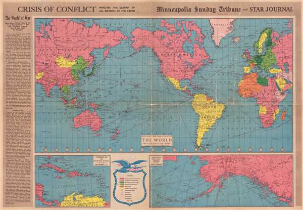
This is a 1942 Minneapolis Sunday Tribune and Star Journal map of the world at the outset of American involvement in World War II. With North America at center, the map depicts the world from Central Asia across the Pacific to the Americas and then across the Atlantic Ocean to Europe and back to Central Asia. Intended as an aid for readers of the Tribune and Star Journal, each country is shaded in the color representing the alliance of which it was a member or by which force (Allied or Axis) currently occupied a given country. Allied nations and those occupied by the Allies are colored shades of pink, while nations belonging to or occupied by the Axis are colored with shades of green. Neutral nations are colored yellow, allowing them to stand out in stark contrast to the rest, while Vichy France and its possessions are orange, signifying the unique (and precarious) position held by Pétain and the Vichy regime. The Tribune and the Star Journal hoped that their readers would keep this map and use it to track the developments during 'the greatest war of all time'. The Tribune and the Star Journal suggest using push pins to track movements and changes in territory, as events have the potential to change quickly.
As of this map's printing, most of Europe had been conquered by the Axis and the Japanese were steamrolling through Southeast Asia and the East Indies. Fighting raged on the Eastern Front between Germany and the Soviet Union, while American air and sea power had engaged the Empire of Japan throughout the Pacific. American ground forces would not engage in combat until the Battle of Guadalcanal, which would not begin until August 1942.
Numerous aspects of this map would allow for the every-day viewer to have a much better understanding of when and where events during the war took place. Time zones are illustrated and labeled on the main map, indicating the time difference from Minnesota to the combat zone, either in the Pacific or Europe. Every country is labeled, along with the archipelagos in the Pacific and even individual islands. Air and sea routes across the globe are rendered as well and include the distance (in miles) from one point to the other. Cities and towns throughout the world are also labeled, making it easy for someone to locate a far-away city currently in the news. Two inset maps are included along the bottom border. One, situated on the bottom left, depicts the Caribbean and the eastern approach to the Panama Canal, a very strategic asset for the United States, which was fighting in both the Atlantic and Pacific Oceans. Without control of the Panama Canal, vessels wanting to travel from one ocean to the other would have to round Tierra del Fuego, a time-consuming and dangerous endeavor. The other, on the bottom right, illustrates the Aleutian Islands in Alaska, believed by the Tribune and the Star Tribune to 'point like a gun barrel toward Japan'. A key explaining the colors and symbols utilized on the map is situated in between the two inset maps along the bottom border.
This map was created by Rand McNally and published by the Minneapolis Sunday Tribune and the Minneapolis Star Journal on May 3, 1942.
CartographerS
The Minneapolis Tribune (1867 - present) was founded by Colonel William S. King, William D. Washburn, and Dorilus Morrison and the first issue was published on May 25, 1867. In 1941, the Cowles family of Des Moines, Iowa bought the Tribune and merged it with their other holdings in Minneapolis, giving the Cowles family ownership of all the city's major newspapers. The Tribune became the city's morning newspaper, and the Star-Journal was the evening newspaper. The two published a joint Sunday edition. The newspaper is still published today, under the name Star Tribune. More by this mapmaker...
Rand, McNally and Co. (fl. 1856 - present) is an American publisher of maps, atlases and globes. The company was founded in 1856 when William H. Rand, a native of Quincy, Massachusetts, opened a print shop in Chicago. Rand hired the recent Irish immigrant Andrew McNally to assist in the shop giving him a wage of 9 USD per week. The duo landed several important contracts, including the Tribune's (later renamed the Chicago Tribune) printing operation. In 1872, Rand McNally produced its first map, a railroad guide, using a new cost effective printing technique known as wax process engraving. As Chicago developed as a railway hub, the Rand firm, now incorporated as Rand McNally, began producing a wide array of railroad maps and guides. Over time, the firm expanded into atlases, globes, educational material, and general literature. By embracing the wax engraving process, Rand McNally was able to dominate the map and atlas market, pushing more traditional American lithographic publishers like Colton, Johnson, and Mitchell out of business. Eventually Rand McNally opened an annex office in New York City headed by Caleb S. Hammond, whose name is today synonymous with maps and atlases, and who later started his own map company, C. S. Hammond & Co. Both firms remain in business. Learn More...
Condition
Average. Newsprint. Professionally backed on archival tissue to provide stabilization. Cracks and tears along original fold lines. Displays one five and one half inch tear in Eastern Hemisphere and one six inch tear in Western Hemisphere. Text and photographic content on verso.