1836 Direccion Hidrografia Chart of Central Cuba
Cuba-direccionhidrografia-1836$1,600.00


Title
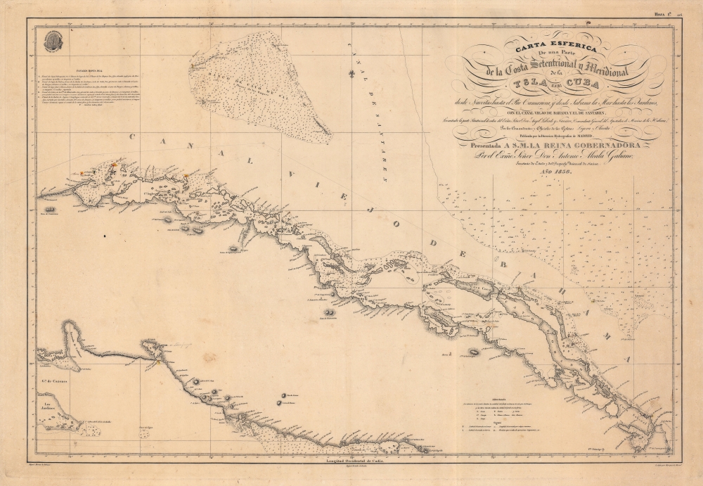
Carta Esferica de una parte de la Costa Setentrional y Meridional de la Isla de Cuba, desde Nuevitas hasta el rio Camarioca y desde Labana la Mar hasta los Jardines, con el Canal viejo de Bahama y el de Santaren.
1836 (dated) 23 x 34.25 in (58.42 x 86.995 cm) 1 : 466000
1836 (dated) 23 x 34.25 in (58.42 x 86.995 cm) 1 : 466000
Description
A beautifully engraved 1836 nautical chart of the central portion of Cuba and surrounding waters produced by Spain's Dirección de Hidrografía. It highlights the difficulty of navigating the Old Bahama Channel (Canal Viejo de Bahama), the waters between the Bahamas and Cuba.
Handwritten annotations provide additional, updated information and appear to track the progress of a ship across the waters off Cuba's northern coast. Although some beacons (listed at left) had been erected by the time of this chart's production, they were supplemented or superseded in subsequent years by lighthouses, which are indicated by yellow and red coloring. The Elbow Reef Lighthouse depicted here near Cayo Codo is still operational, one of the last kerosene burning lighthouses in the world.
A Closer Look
The top portion of the chart is occupied by cays (including Cay Sal and Elbow Cay or Cayo Codo) and shallow waters of the Bahamas, while the bottom half includes the northern and southern coast of central Cuba, stretching on the north side from the west near Matanzas eastwards to the Cayo Sabinal, and on the south side including a smaller area around Cienfuegos (here as Xagua, also spelled Jagua, with the modern name penciled in). Soundings, hazards, shoals, and other information are noted throughout, including those explained by abbreviations and symbols in a key near bottom-right. Longitude is measured from the Real Instituto y Observatorio de la Armada at San Fernando in Cadiz.Handwritten annotations provide additional, updated information and appear to track the progress of a ship across the waters off Cuba's northern coast. Although some beacons (listed at left) had been erected by the time of this chart's production, they were supplemented or superseded in subsequent years by lighthouses, which are indicated by yellow and red coloring. The Elbow Reef Lighthouse depicted here near Cayo Codo is still operational, one of the last kerosene burning lighthouses in the world.
Publication History and Census
The chart was drawn by Miguel Moreno and engraved by Rafael Estebe (perhaps the same as contemporary Court Engraver Rafael Esteve), with letter engraving undertaken by the Marquerie Brothers, for the Dirección de Hidrografía in 1836. It is a rare map, scarce to the market and not listed among the holdings of any institution.CartographerS
The Direccion Hidrografía (1787 - 1927), also known as the Deposito Hydrografico and the Direction de Hidrografía, was the Spanish equivalent of the British Admiralty or the U.S. Coast Survey. This organization, founded in 1787, was commissioned to collect and produce accurate nautical charts of all waters frequented by Spanish vessels. In essence, it replaced the Casa de la Contratación de las Indias (House of Trade of the Indies), which closed its doors in 1790. Like most such organizations, the Direccion Hidrografía marked a new age in cartography. Rather than simply collect charts created by navigators, explorers, and merchants, the Direccion Hidrografía worked closely with naval and military personnel to mount cartographic and hydrographic expeditions in pursuit of the most accurate hydrographical, astronomical, and geodetic measurements. The Direccion Hidrografía created a massive library of nautical charts that, though not nearly as common as similar nautical charts by the U.S. Coast Survey and British Admiralty, are highly desirable for the beauty of their manufacture as well as their accuracy and detail. The office was originally located on Calle Ballesta, but relocated to 36 Alcala, both in Madrid. After 1908 the Dirección was subsumed into other governmental agencies. In 1927 the Direccion was absorbed into the Institute and Observatory of San Fernando, located in Cadiz. The library of original maps, charts, and journals was transferred to the Naval Museum of Madrid - where it resides to this day. More by this mapmaker...
Miguel Moreno (fl. c. 1792 - 1845) was a Spanish cartographer and draftsman active with the Depósito Hidrográfico in Madrid during the first half of the 19th century. Hs served in the Spanish royal navy as a pilot as early as 1808. By 1807 he was producing nautical charts for the Depósito Hidrográfico. He participated in the geographical expedition to South America of Cosme Damián Churruca (1792 - 95), which included the Antilles. Moreno was widely considered the Depósito Hidrográfico's primary expert on the Gulf Coast and Puerto Rico. Learn More...
Condition
Very good. Fairly even toning. Very light sporadic foxing and other imperfections.