This item has been sold, but you can get on the Waitlist to be notified if another example becomes available, or purchase a digital scan.
1892 Rand McNally Map of Cuba
Cuba-randmcnally-1893$45.00

Title
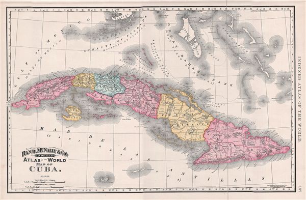
Map of Cuba.
1892 (dated) 13.5 x 20.5 in (34.29 x 52.07 cm) 1 : 2400000
1892 (dated) 13.5 x 20.5 in (34.29 x 52.07 cm) 1 : 2400000
Description
A beautiful example of Rand McNally and Company's 1892 map of Cuba. The map covers the entire island of Cuba including the Salt Sea Banks and the Isla de la Juventud or the Isla de Pinos (Isle of Pines) as it was until 1978. A divisional line dividing the island into two dioceses viz. archbishopric of Santiago de Cuba and the bishopric of Habana is noted. Three years after this map was created, the Cuban War of Independence, the last of the three wars against Spain would begin in 1895 and would eventually lead to the Spanish-American War of 1898. As a result, Spain would be forced to cede the Philippine Islands, Puerto Rico and Guam to the United States, as well as relinquish sovereignty over Cuba. Color coded according to regions and territories, the map notes several towns, rivers, cities, railroads, mountains and other topographical details with relief shown by hachure. This map was issued as plate no. 187 in the 1893 issue of Rand McNally and Company's Indexed Atlas of the World- possibly the finest atlas Rand McNally ever issued.
Cartographer
Rand, McNally and Co. (fl. 1856 - present) is an American publisher of maps, atlases and globes. The company was founded in 1856 when William H. Rand, a native of Quincy, Massachusetts, opened a print shop in Chicago. Rand hired the recent Irish immigrant Andrew McNally to assist in the shop giving him a wage of 9 USD per week. The duo landed several important contracts, including the Tribune's (later renamed the Chicago Tribune) printing operation. In 1872, Rand McNally produced its first map, a railroad guide, using a new cost effective printing technique known as wax process engraving. As Chicago developed as a railway hub, the Rand firm, now incorporated as Rand McNally, began producing a wide array of railroad maps and guides. Over time, the firm expanded into atlases, globes, educational material, and general literature. By embracing the wax engraving process, Rand McNally was able to dominate the map and atlas market, pushing more traditional American lithographic publishers like Colton, Johnson, and Mitchell out of business. Eventually Rand McNally opened an annex office in New York City headed by Caleb S. Hammond, whose name is today synonymous with maps and atlases, and who later started his own map company, C. S. Hammond & Co. Both firms remain in business. More by this mapmaker...
Source
Rand McNally & Co., Rand, McNally & Co's Indexed Atlas of the World, (Chicago) 1893.
Condition
Very good. Text on verso.
References
Rumsey 3565.052 (1897 edition). Philip (atlases) 1026 (1898 edition).