
1821 Direccion Hidrografia Chart of Cuba and the Cayman Islands

This item has been sold.
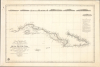
Carta esferica que comprende la costa meridional, parte de la setentrional é yslas adyacentes de la isla de Cuba: desde la punta de Maisi hasta Cabo S. Antonio levantada de orden superior en 1793 por el Teniente de Navio Don Ventura de Barcaiztegui, y en 1804, por el Capital de Fragata D. José del Rio.
Chart that enabled the accurate measurement of Cuba. (Humboldt).
- Digital Map Information
- Suitable for large format printing
- Full resolution TIFF file
- ICC color profile embedded
- Delivered instantly via download link
Chart that enabled the accurate measurement of Cuba. (Humboldt).
This superb nautical map, produced in 1821 by Spain's Dirección de Hidrografía, presents the best charting of Cuba's southern coast then published. Its quality was hailed by no less a contemporary luminary than German geographer, naturalist, and explorer Alexander von Humboldt (1769 - 1859). Before its publication, it was impossible to accurately determine Cuba's actual size. In addition to its novel mapping of Cuba, the chart also features updated coverage of the Cayman Islands, including seven place names on Grand Cayman.A Closer Look
The chart is focused primarily on the southern coast of Cuba, from Cape San Antonio in the west to Punta de Maisi in the east. It continues mapping the coast around Punta de Maisi to the northwest, reaching the Punta del Maternillo and the key landmark Alto de Juan Dañue. Of primary interest is the coastline from Punta de Piedras to Cabo de la Cruz, including Isla del Pinos. This coastline, filled with Cays and treacherous shallows, is here mapped in detail. Soundings, currents, and inlets are meticulously recorded. A letter key indicates the consistency of the ocean floor where soundings were taken. The chart also notes where latitude and longitude were taken from land, at sea, and by trigonometrical survey. The island of Grand Cayman is noted to have been corrected in 1828. Under the letter key to the right are extensive notes pertaining to lighthouses (fanales) dated to 1854. On the chart, the lighthouses of Cabo de San Antonio, Bahia de Jagua, and Santiago de Cuba are highlighted with hand color.Along the top of the chart are 7 coastal profiles, showing the coastlines of Cabo de San Antonio, Cabo Corrientes, the Isla de Pinos, three views detailing newly-surveyed peaks of Cuba's central Sierras, and the Ojo del Toro just beyond Cabo de Cruz.
A Celebrated Work
Two Spanish naval officers were credited with the chart's surveys - Lieutenant Don Ventura de Barcaíztegui (1793) and Captain Don José del Río (1804). Neither of these marine surveyors is well known, despite the latter having produced further surveys for the Dirección de Hidrografía. Nevertheless, their work on this specific chart did not go unnoticed. In his 1826 Essai politique sur l'île de Cuba, Alexander von Humboldt, the scientific celebrity of his day, described the problem that this chart solved:The island of Cuba being surrounded with shoals and breakers along more than two-thirds of its length, and as ships keep out beyond those dangers, the real shape of the island was for a long time unknown. Its breadth, especially between the Havannah and the port of Batabano, has been exaggerated; and it is only since the Deposito Hidrografico of Madrid published the observations of captain Don José del Rio, and lieutenant Don Ventura de Barcaiztegui, that the area of the island of Cuba could be calculated with any accuracy.
Publication History and Census
This chart was engraved by Felipe Cardano and published by the Dirección de Hidrografía in 1821. We are aware of two states of this chart: this example is the second, containing corrections dated as late as 1854. While the chart has appeared on the market from time to time, it should be considered scarce; it is cataloged in only five institutional collections.Cartographer
The Direccion Hidrografía (1787 - 1927), also known as the Deposito Hydrografico and the Direction de Hidrografía, was the Spanish equivalent of the British Admiralty or the U.S. Coast Survey. This organization, founded in 1787, was commissioned to collect and produce accurate nautical charts of all waters frequented by Spanish vessels. In essence, it replaced the Casa de la Contratación de las Indias (House of Trade of the Indies), which closed its doors in 1790. Like most such organizations, the Direccion Hidrografía marked a new age in cartography. Rather than simply collect charts created by navigators, explorers, and merchants, the Direccion Hidrografía worked closely with naval and military personnel to mount cartographic and hydrographic expeditions in pursuit of the most accurate hydrographical, astronomical, and geodetic measurements. The Direccion Hidrografía created a massive library of nautical charts that, though not nearly as common as similar nautical charts by the U.S. Coast Survey and British Admiralty, are highly desirable for the beauty of their manufacture as well as their accuracy and detail. The office was originally located on Calle Ballesta, but relocated to 36 Alcala, both in Madrid. After 1908 the Dirección was subsumed into other governmental agencies. In 1927 the Direccion was absorbed into the Institute and Observatory of San Fernando, located in Cadiz. The library of original maps, charts, and journals was transferred to the Naval Museum of Madrid - where it resides to this day. Further Details...
Condition
Very good. Re-cornered at upper right. Some marginal ink stains not impacting image. Pencil notation correcting 'Pto de Xagua' to 'Cíenfuegos.'
References
OCLC 979423405. Cueto, E., Cuba in Old Maps, no. 59.