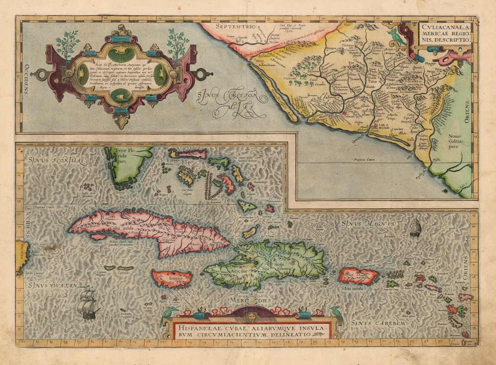
1603 Ortelius Map of Cuba, the Caribbean, and Northwestern Mexico
CuliacanCuba-ortelius-1579-3$2,000.00

Title
Culiacanae, America Regionis Descriptio./ Hispaniolae, Cubae, Aliarumque Insularum Circumiacentium, Delineatio./ Cum Imp. et Regio./ privilegio decennali 1579.
1579 (dated) 15.5 x 19.5 in (39.37 x 49.53 cm) 1 : 8000000
1579 (dated) 15.5 x 19.5 in (39.37 x 49.53 cm) 1 : 8000000
Description
This is a beautiful, original color example of Ortelius' 1579 map of Cuba and the Caribbean, combined with his map of the Viceroyalty of Culiacan in Northwestern Mexico. Moreover, this is a Vrients edition of the map: maps from Vrients editions typically exhibit finer quality color than those printed during Ortelius' lifetime and are consequently very desirable.
Among Ortelius' Most Original Maps
While Ortelius is generally most esteemed as an editor and compiler of maps, he was an accomplished mapmaker in his own right. This map is among those of his own composition, synthesizing data drawn from Mercator's 1569 world map, Gutierrez's 1562 America map, and Alonso de Santa Cruz's 1560 Isolario (sources now unobtainable by the collector). These maps, both of essential areas of recent exploration in the New World, exemplify Ortelius' trail-blazing cartographic work.Culiacán and Northwestern Mexico
The upper of the two maps on this sheet brings into sharp focus the Viceroyalty of Culiacán, in the modern Mexican state of Sinaloa. The modern city of Culiacán appears here as the Villa San Michaelis, which was founded in 1531 by Lázaro de Cebreros and Nuño Beltrán de Guzmán. The region had been organized under the tribe of the Tahues. Following a war of conquest, the Spanish reorganized the area into three provinces: Culiacán, Sonora, and Sinaloa. The region was further explored by Coronado and Alarcón in the 1540s. It was the furthest point north explored by Cortez in his search for the Seven Cities of Gold. The map presents a multiplicity of pre-Spanish settlements surrounding the two Spanish colonial towns of Culiacán and San Miguel de Culiacán. Mountain ranges and palm groves appear as well.Not California
The coastal region today is marked by barrier islands, which are likewise depicted on this map - in a formation sometimes misidentified as an insular California. (This myth would not take hold on maps until the next century.) The body of water beyond the barrier islands, Sinus Caleforniae, shows that the Baja Peninsula would appear outside the western border of the map.Cuba and the Caribbean
The map of Cuba and the Caribbean is superbly detailed, and includes part of Florida, the Bahamas, and a glimpse of the Yucatán. The principal cities of the islands are illustrated. The map is centered on Cuba and Hispaniola. The treacherous waters of the Bahamas islands are marked with the infamous Homeric terrors of Scylla and Charybdis, showing that the islands' perilous shallows and reefs were already infamous. The beautifully engraved oceans are decorated with two sailing ships.An Oblique Credit?
The stylistic differences between the two maps are striking: Culiacanae's waters are stippled, typical of Ortelius' other maps. The waves of the Caribbean show the style of Ortelius' colleague and contemporary Mercator, perhaps suggesting that Ortelius' source for this part of the map was Mercator's 1569 wall map. This hint is also supported by Ortelius' use of the place name 'Aiti' in Hispaniola, a term used on Mercator's map but not on other contemporary maps of the island.Publication History and Census
The map was produced for inclusion in Ortelius' Theatrum Orbis Terrarum, first appearing in 1579 editions of the work. The first state of this map had mislabeled the Tropic of Cancer as the Tropic of Capricorn; this error was corrected in 1595; the present map is thus a second state, showing that correction. Based on the verso text, this second state example can be identified as having been included in the 1603 Latin edition of Ortelius' atlas, published posthumously under the aegis of his executor, J. B. Vrients. Van den Broecke estimates that approximately 5,875 copies of this map in all editions were printed for inclusion in Ortelius' atlas, and it is fair to assume that perhaps ten percent of these have survived in one form or another. The map is well represented in institutional collections, and it appears on the private market with some regularity, but old color examples of this quality have become difficult to find.CartographerS
Abraham Ortelius (April 14, 1527 - June 28, 1598) also known as Ortels, was a cartographer, geographer, and cosmographer of Brabant, active in Antwerp. He was the creator of the first modern atlas, Theatrum Orbis Terrarum and is a seminal figure in the history of cartography. Along with Gerard Mercator and Gemma Frisius, he was a founder of the Netherlandish school of cartography. His connections with Spain - culminating in his 1575 appointment as Royal Cartographer to King Phillip II of Spain - gave him unmatched access to Spanish geographical knowledge during a crucial period of the Age of Discovery. Ortelius was born in 1527 in Antwerp. In 1547 he entered the Antwerp Guild of Saint Luke as an illuminator of maps. He began trading in books, prints, and maps, traveling regularly to the Frankfurt book and print fair, where in 1554 he met Mercator. He accompanied Mercator on journeys throughout France in 1560 and it was at this time, under Mercator's influence, that he appears to have chosen his career as a scientific geographer. His first published geographic work appeared in 1564, an eight-sheet cordiform world map. A handful of other maps preceded the 1570 publication of the first edition of the Theatrum Orbis Terrarum, which would prove to be his life work. Appearing with but 53 maps in its first edition, Ortelius' work expanded with new maps added regularly. By 1592, it had 134 maps. Many of Ortelius' maps remained the standard for nearly a century. He traveled extensively, but his genius was as a compiler, locating the best informed maps on which to base his own. His contacts throughout Europe and extending even (via the Portuguese) to the Far East were formidable. Moreover, many of his maps were based on his own scholarship, particularly his historical works. His theories of geography were particularly ahead of his time with respect to the notion of continental drift, the possibility of which he mused on as early as 1596, and which would be proven correct centuries later.
In a sense his greatest achievement was his successful navigation of the religious and political violence endemic to his city throughout his adult life: The Dutch Revolt, or Eighty Years' War (1568 - 1648), fully embroiled Antwerp. Although outwardly and officially recognized as Catholic (Arias Montanus vouched for Ortelius' Catholic orthodoxy prior to his appointment as Royal Geographer), Ortelius was able to separate himself from the religious furor which characterized the war in the low countries. Ortelius showed a glimpse of himself in a letter to a friend, regarding humanist Justus Lipsius: 'I do not know whether he is an adherent of the Pope or a Calvinist, but if he has ears to hear, he will neither be one nor the other, for sins are committed on both sides'. Ortelius' own explorations of Biblical history in his maps, and the Christogram contained in his own motto, suggest him to be a religious man, but his abjuration of political religious authorities mark him as an individualist. His tombstone at St Michael's Præmonstratensian Abbey in Antwerp bears the inscription, Quietis cultor sine lite, uxore, prole. ('served quietly, without accusation, wife, and offspring.') More by this mapmaker...
Johannes Baptista Vrients (1552 - 1612) was a Flemish engraver, publisher, and mapseller. Little is known of his early years, but it is to be assumed he came up as an apprentice among the mapmakers of Antwerp, where the guild named him a master in 1575. In the 1590s, he executed world maps for Plancius and Linschoten. (In 1600, after Ortelius died, he became the estate's executor and acquired the plates for the Theatrum.) He would go on to publish further editions of the Ortelius atlas between 1606 and 1612. Vrients also acquired the plates for Gerard De Jode's (1516/17 - 1591) Speculum in and around 1600, but he did not republish that work - though he would preserve the De Jode plates depicting the Electors of the Holy Roman Empire, reprinting it in his editions of the Ortelius atlas after 1603. Most likely, his purchase of the De Jode plates was a play to keep them off the market. Vrients' editions of the Theatrum were not published in Antwerp (that city having fallen during the Dutch war with Spain) but in Amsterdam. Learn More...
Source
Ortelius, A., Theatrum Orbis Terrarum, (Antwerp: Vrients) 1603.
Abraham Ortelius' magnum opus, Theatrum Orbis Terrarum, was the world's first regularly produced atlas, which 'set the standards for later atlases . . . It was the first undertaking of its kind to reduce the best available maps to an uniform format.' (Koeman) A modestly-sized work of fifty-three maps in its first edition of May 1570, it was an immediate success: there were three further editions that year, and the work remained in print for a total of 32 editions, the last of which was 1641, well after its author's 1598 death. Ortelius added to his atlas constantly, and by 1595 the Theatrum contained 147 maps. Ortelius is renowned generally as an editor, and indeed much of the Theatrum is compiled from a variety of sources: in such cases, Ortelius was scrupulous in naming his sources. But Ortelius was also a mapmaker in his own right: many of his maps are a distillation of various sources into his own work, and there were many maps - particularly in his atlas of Biblical and ancient history Parergon - which were entirely Ortelius' work. In his role as an editor, Ortelius followed in the footsteps of Munster, whose Cosmographia was, until Ortelius, the best window on the world for the curious European reader. In terms of the artistry of his maps, Ortelius oversaw the first great flourishing of copperplate engraving in the service of cartography to occur in Northern Europe. Ortelius' work provided the model for the atlases of Mercator, Hondius, Blaeu and all their progeny in the 17th century - many of whom were to produce faithful editions of Ortelius' maps in their own productions.
Condition
Very good. Mends to bottom centerfold with no loss. Else excellent with superb original color.
References
Rumsey 10001.071. OCLC 871202152. Koeman Ort 73. Van der Krogt, P. C. J., Koeman's Atlantes Neerlandici, (3 Vols), 9520:31, 9610:31. Van den Broecke, Ort 14ab. state 2.