This item has been sold, but you can get on the Waitlist to be notified if another example becomes available.
1852 Chase Map of Cumberland County, Maine (Portland, Casco Bay)
CumberlandMaine-chase-1852$1,000.00

Title
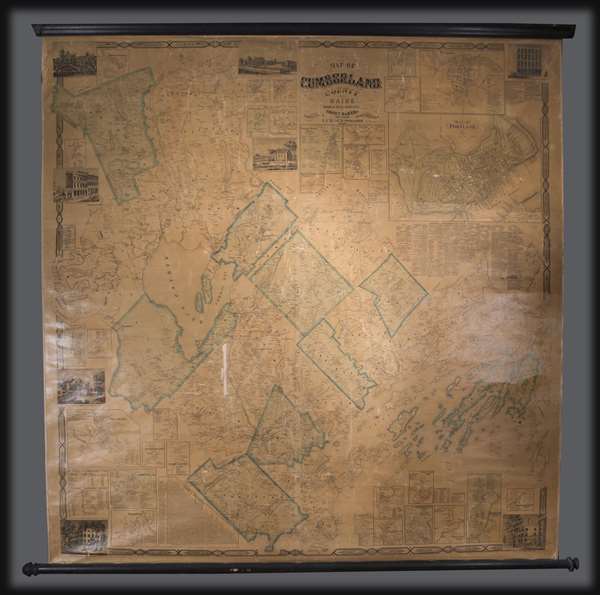
Map of Cumberland County Maine from actual surveys.
1857 (dated) 58 x 56 in (147.32 x 142.24 cm) 1 : 51600
1857 (dated) 58 x 56 in (147.32 x 142.24 cm) 1 : 51600
Description
An attractive 1857 wall map of Cumberland County, Maine, including Portland and the Casco Bay region. The map extends from Bridgton to Casco Bay, and from Lake Sebago to Brunswick, with details to the level of individual property owners. There are insets of 32 town, including a large and detailed plan of Portland. Beneath the Portland Plan there is a list of 'Portland Subscribers' and a local business directory. Eight pictorial vignettes are incorporated into the border of the map. These focus on local businesses who probably paid for the privilege of being so represented, and noteworthy personal estates.
As the title notes, this map is based upon original surveys conducted by the civil engineer Sidney Baker and the map publisher J. Chace Jr. We are aware of only a single edition. This map is uncommon to the market.
As the title notes, this map is based upon original surveys conducted by the civil engineer Sidney Baker and the map publisher J. Chace Jr. We are aware of only a single edition. This map is uncommon to the market.
Condition
Good. Unrestored wall map. Slight loss. Linen backing brittle. Toning. Attached to rollers.
References
OCLC 807284155,822962913.