This item has been sold, but you can get on the Waitlist to be notified if another example becomes available, or purchase a digital scan.
1934 Harkins Cyanotype Print of 1851 Walling City Map or Plan of Bath, Maine
CyanotypeBath-harkins-1934$150.00

Title
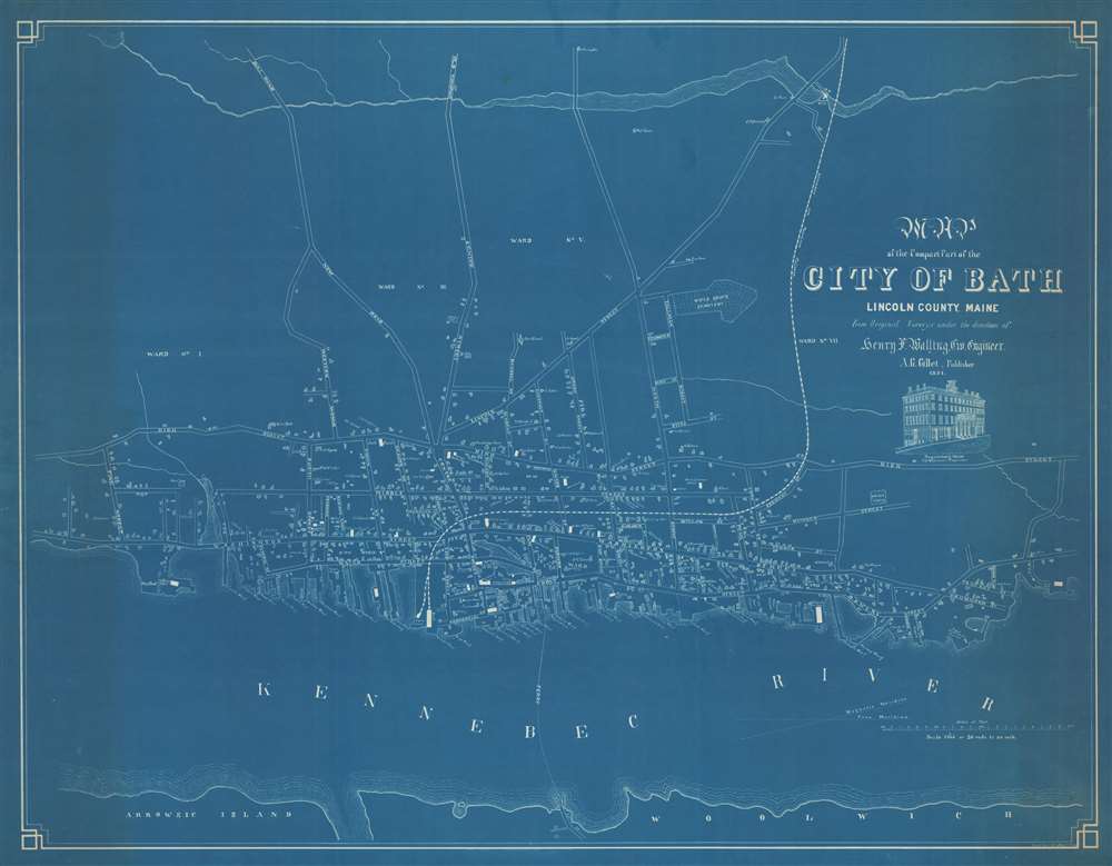
Map of the Compact Part of the City of Bath, Lincoln County, Maine.
1934 (dated) 28.25 x 36.5 in (71.755 x 92.71 cm) 1 : 3960
1934 (dated) 28.25 x 36.5 in (71.755 x 92.71 cm) 1 : 3960
Description
A unique find, this is a 1934 Margaret W. Harkins cyanotype print of an 1851 Henry Frances Walling city map or plan of Bath, Maine. Oriented toward the west, the map depicts the city from Pine Street to the steam mill on the banks of the Kennebec River and from Sewell's Mills on what appears to be Whiskeag Creek west of town (although it is unlabeled) to the Kennebec River. Due to this map's unusually large scale for Walling city plans, the properties of individuals in town are illustrated and identified with the owner's name along with the streets and public buildings. Nearly all the streets are labeled, as are the wharves along the Kennebec, the shipyards, churches, hotels, and schools. City wards are labeled and the Kennebec and Portland Railroad line runs to a depot on the river. The ferry crossing from Bath to Woolwhich across the Kennebec is also illustrated. A view of Sagadahock House is situated just below the title.
Cyanotype: Why so Blue?
Cyanotype is a photo-reprographic technique developed in 1842 by the British astronomer John Herschel (1792 - 1871). Sometimes called a 'sunprint', the technique employs a solution of ferric ammonium citrate and potassium ferricyanide, which painted on white paper or cloth, reacts when exposed to sunlight to dye the object a brilliant blue. Areas blocked from ultraviolet exposure remain undyed and white. Herschel developed the technique to reproduce his astronomical notes, but others quickly realized that any object capable of blocking light could be used to quickly and easily create a cyanotype image. By the late 19th century the process became popular with designers, military, architects, and engineers (blueprints), who used the cheap an effective technique to quickly and exactly reproduce images in the field. Cyanotyping is limited in that only a single copy can be made at one time, so it was only practical for short-term field work. It is also of note that cyanotypes remain extremely reactive to light and, over time, fade or degrade, making them extremely ephemeral. The process fell out of fashion in most places by the 1920s, but remains in use in some parts of the world, such as India and Nepal, to this day.Publication History and Census
This map was created by Margaret W. Harkins in 1934 as a cyanotype print of an 1851 Henry F. Walling city map or plan of Bath, Maine. No concrete census data is available as we have been unable trace Margaret Harkins, but, because it is a cyanotype, it is likely that the present example was part of a very short print run due to the nature of creating prints using this process.Cartographer
Henry Francis Walling (June 11, 1825 - April 8, 1889) was an American civil engineer, cartographer, surveyor, and map publisher active from the middle to late 19th century. Walling was born in Providence, Rhode Island. He studied/worked at the Providence Athenaeum before discovering a talent for mathematics and surveying. Walling took a position with Samuel Barrett Cushing (1846 - 1888), a Providence-based civil engineer with whom he issued in 1846 a revision of James Steven's Topographical Map of the State of Rhode-Island. Walling established himself independently around 1850 and immediately began preparing a series of town plans focusing on Bristol County, near Providence. Buoyed by widespread interest in his plans, Walling expanded his operations to Massachusetts, where, by 1857, he had produced no less than 50 town plans. Apparently, Walling's business model involved a contract with town officials to produce a certain number of maps, after which he acquired the right to print and sell additional copies on his own account. This work eventually led to Walling's appointment as Massachusetts "Superintendent of the State Map", a designation that began appearing on his maps around 1855. While Walling's work focused heavily on city and county maps, he successfully published three scarce state maps: Maine, Vermont, and Rhode Island. In 1856, Walling relocated his headquarters to New York City, where he had better access to quality lithographers. The Civil War (1861 - 1865) proved difficult for Walling, and diminished sales may have forced him into a partnership with Ormando W. Gray, with whom he published numerous state, county, and national atlases in the 1860s and 1870s. Around 1880, Walling took a post with the U.S. Coast Survey, with whom he worked on various charts until requesting a transfer in 1883 to the newly formed U.S. Geological Survey. Walling remained with the Geological Survey until his untimely death of a heart attack in April 1889. More by this mapmaker...
Condition
Very good. Light soiling. Closed margin tear professionally repaired on verso. Blank on verso.