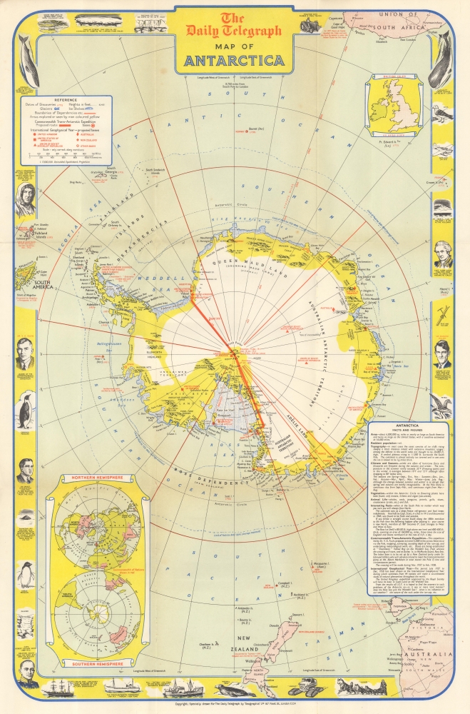
1957 Geographia and 'Daily Telegraph' Pictorial Map of Antarctica
DailyTelegraphAntarctica-geographia-1957
Title
1957 (undated) 29 x 18.5 in (73.66 x 46.99 cm) 1 : 17000000
Description
The Commonwealth Trans-Antarctic Expedition of 1955 - 1958
The Commonwealth Trans-Antarctic Expedition (CTAE) completed the first overland crossing of the Antarctic continent and was the first overland expedition to reach the South Pole since Scott's expedition in 1912. Although CTAE was technically a private venture, it was a sponsored by the Commonwealth and supported by the governments of Australia, New Zealand, South Africa, the United Kingdom, and the United States, along with donations from corporations and individuals under the patronage of Queen Elizabeth II. British explorer Vivian Fuchs headed the expedition, and Sir Edmund Hillary (most remembered as the first person to successfully summit Mount Everest) led the New Zealand Ross Sea Support Team.The 12-person team set out from Shackleton Base in November 1957 and conducted experiments along the way. At the same time, Hillary set out from Scott Base at McMurdo Sound to set up supply depots for Fuchs and his team as they approached their destination.
The International Geophysical Year
The International Geophysical Year (IGY) was a global effort to encourage scientific interchange and undertake scientific projects. The year began on July 1, 1957, and continued through December 31, 1958. Projects included 14 Earth science disciplines: airglow, aurora, cosmic rays, geomagnetism, glaciology, gravity, ionospheric physics, longitude and latitude determinations, meteorology, nuclear radiation, oceanography, rockets and satellites, seismology, and solar activity. 67 countries participated in IGY projects, including the United States and the Soviet Union, ending a long period of no scientific interchange between the East and the West. The People's Republic of China was the most notable exception, and it did not participate to protest the participation of the Republic of China (Taiwan). That same year, both the United States and the Soviet Union launched artificial satellites. The Soviet satellite was Sputnik 1, the first artificial satellite. Sputnik caused hysteria in the United States and had a direct effect on beginning the 'Space Race'.Publication History and Census
This map was drawn by Geographia Ltd. and published by The Daily Telegraph in 1957. We note 14 examples cataloged in OCLC in collections in the United States, the United Kingdom, Australia, and New Zealand.Cartographer
Geographia, Ltd. (1911 - 1985) was a London-based cartographic publishing firm. The company was founded by Alexander Gross (1879 - 1958), a Hungarian immigrant to the United Kingdom. Geographia Ltd. is best known for its folding pocket maps and globes. Many of his maps were drawn by a mysterious 'Mr. Fountain', of whom we have been able to discover little. Gross ran into financial problems around 1940, likely associated with World War II, and relocated to offices in New York at 11 John Street. There, he issued a large corpus of U.S.-focused maps and city plans. By the 1940s, the branch in the United States had been renamed the Geographia Map Company and experienced rapid growth. By the 1950s, Geographia had published maps of dozens of cities across the United States. In 1987, the British branch was bought out by Harper Collins and continues to produce maps under the Collins Bartholomew imprint. Rand McNally bought the New York-based Geographia Map Company in the late 1980s. However, its original owners repurchased the Geographia Map Company a few years later and still operate the company in Hackensack, New Jersey. Gross's daughter, Phyllis Isobella Gross / Pearsall (1906 - 1996), founded the Geographers' A-Z Map Company in London, the largest independent map publisher in the United Kingdom. In the UK, their offices were originally at 33 Strand, where they published as 'Geographia Designing and Publishing Company Ltd.'. Later, by 1933, they had relocated to 55 Fleet Street, where they remained until at least 1937. By 1942, they relocated to 167 Fleet Street, followed by 114 Fleet Street by 1964. It is of note that many of the Geographia Ltd. maps feature a peculiar dating system wherein the letters in the world CUMBERLAND correspond to the numbers 1234567890, such that a date is rendered by substitution, so A.MU would break out like this A = 8, M = 3, U = 2, so 8.32 or, August 1932. Or, MM.YY e.g. E.MC = 5.31 = May 1931. More by this mapmaker...

