
Geographia, Ltd.

Geographia, Ltd. (1911 - 1985) was a London-based cartographic publishing firm. The company was founded by Alexander Gross (1879 - 1958), a Hungarian immigrant to the United Kingdom. Geographia Ltd. is best known for its folding pocket maps and globes. Many of his maps were drawn by a mysterious 'Mr. Fountain', of whom we have been able to discover little. Gross ran into financial problems around 1940, likely associated with World War II, and relocated to offices in New York at 11 John Street. There, he issued a large corpus of U.S.-focused maps and city plans. By the 1940s, the branch in the United States had been renamed the Geographia Map Company and experienced rapid growth. By the 1950s, Geographia had published maps of dozens of cities across the United States. In 1987, the British branch was bought out by Harper Collins and continues to produce maps under the Collins Bartholomew imprint. Rand McNally bought the New York-based Geographia Map Company in the late 1980s. However, its original owners repurchased the Geographia Map Company a few years later and still operate the company in Hackensack, New Jersey. Gross's daughter, Phyllis Isobella Gross / Pearsall (1906 - 1996), founded the Geographers' A-Z Map Company in London, the largest independent map publisher in the United Kingdom. In the UK, their offices were originally at 33 Strand, where they published as 'Geographia Designing and Publishing Company Ltd.'. Later, by 1933, they had relocated to 55 Fleet Street, where they remained until at least 1937. By 1942, they relocated to 167 Fleet Street, followed by 114 Fleet Street by 1964. It is of note that many of the Geographia Ltd. maps feature a peculiar dating system wherein the letters in the world CUMBERLAND correspond to the numbers 1234567890, such that a date is rendered by substitution, so A.MU would break out like this A = 8, M = 3, U = 2, so 8.32 or, August 1932. Or, MM.YY e.g. E.MC = 5.31 = May 1931.
Distributed free to attendees to give them a better idea of how to reach the Royal Route.
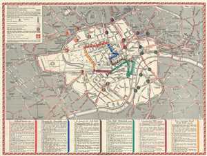
Coronation Arrangements Wednesday May 12 1937.
$200.00
Acquire
- Digital Map Information
- Suitable for large format printing
- File Size: 9.3 MB
- File Type: ZIP / TIFF
- ICC color profile embedded
- Delivered instantly via download link
This is a 1937 city map or plan of London illustrating how well wishers and other attendees could best attend the Coronation of King George VI of Great Britain. The map depicts London from the now closed Uxbridge Road Underground Station (it was on the Metropolitan ... (more details)
Before the government takeover of New York pubic transit.
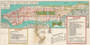
Routes of Fifth Avenue Coach Lines, Inc. / Travel Around New York by Motor Coach Route Map Fifth Avenue Coach Lines, Inc.
$200.00
Acquire
This is a c. 1956 Geographia Map Company map of Fifth Avenue Coach Lines bus routes in Manhattan and Queens, New York City. The map captures part of New York City's bus network just before the city government took over operating the city's buses. (more details)
Celebrating Antarctica.
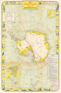
This is a 1957 Geographica and Daily Telegraph pictorial map of Antarctica, celebrating the Commonwealth Trans-Antarctic Expedition of 1955 - 1958 and the International Geophysical Year. While the map names various international claims, within 2 years of its publication, the Antarctic Treaty would transform Antarctica into a jointly-owned international scientific reserve. (more details)