This item has been sold, but you can get on the Waitlist to be notified if another example becomes available, or purchase a digital scan.
1863 Public Survey Map of North Dakota and South Dakota (Dakota Territory)
Dakota-publicsurvey-1863$125.00

Title
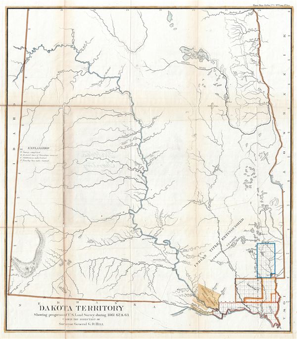
Dakota Territory Showing progress of U.S. Land Survey during 1861, 62 and 63.
1863 (dated) 24 x 21 in (60.96 x 53.34 cm) 1 : 1250000
1863 (dated) 24 x 21 in (60.96 x 53.34 cm) 1 : 1250000
Description
This is a fine 1863 public survey map of North Dakota and South Dakota (Dakota Territory). It covers the states of North Dakota and South Dakota before they were admitted to the Union. The map was prepared to illustrate the progress of the land survey work in the region during 1861, 1862 and 1863. Most of the survey work is limited to the land north of the Niobrarah (Niobrara) River in the southeastern portion of South Dakota, noted via a series of blocks representing the survey grid. An explanation near the left margin describes the various markings in the blocks. The map identifies the area of the Yankton Cession, the Yangton Reservation and the Ponka Reservation. Old Fort George, Fort Lookout and other forts are noted. The map also notes important rivers, creeks, towns and other topography throughout. This map was prepared under the direction of G.D. Hill, Surveyor General, and issued as part of the 1864 congressional report, Message of the President of the United States to the Two Houses of Congress at the Commencement of the First Session of the Thirty-Eighth Congress.
CartographerS
The General Land Office (1812 - 1946) was an independent agency charged with the administration and sale of public lands of the western territories of the United States under the Preemption Act of 1841 and the Homestead Act of 1862. During a time of frenetic energy and rapid westward expansion, the Land Office oversaw the surveying, platting, mapping and eventually the sale of much of the Western United States and Florida. The structural layout of the western United States that we see today, and many of their district and county divisions, are direct result of the early surveying work of the General Land Office. More importantly, as a branch of the Federal Government in Washington D.C. and the only agency able to legally sell and administer public lands in the western territories of the United States, the General Land Office played a pivotal role in consolidating power away from the original states and into the hands of the centralized federal government. The General Land Office was absorbed into the Department of Interior in 1849 and in 1946 merged with the United States Grazing Service to become the Bureau of Land Management. Today the Bureau of Land Management administers the roughly 246 million acres of public land remaining under federal ownership. More by this mapmaker...
Julius (Julien) Bien (September 27, 1826 - December 21, 1909) was a German-Jewish lithographer and engraver based in New York City. Bien was born in Naumburg, Germany. He was educated at the Academy of Fine Arts, Cassell and at Städel's Institute, Frankfurt-am-Main. Following the suppression of the anti-autocratic German Revolutions of 1848, Bien, who participated in the pan-German movement, found himself out of favor in his home country and joined the mass German immigration to the United States. Bien can be found in New York as early as 1849. He established the New York Lithographing, Engraving & Printing Company in New York that focused on the emergent chromo-lithograph process - a method of printing color using lithographic plates. His work drew the attention of the U.S. Government Printing Office which contracted him to produce countless government maps and surveys, including the Pacific Railroad Surveys, the census, numerous coast surveys, and various maps relating to the American Civil War. Bien also issued several atlases both privately and in conjunction with a relation, Joseph Bien. At the height of his career Bien was elected president of the American Lithographers Association. After his death in 1909, Bien's firm was taken over by his son who promptly ran it into insolvency. The firm was sold to Sheldon Franklin, who, as part of the deal, retained the right to publish under the Julius Bien imprint. In addition to his work as a printer, Bien was active in the New York German Jewish community. He was director of the New York Hebrew Technical Institute, the New York Hebrew Orphan Asylum, and president of the B'nai B'rith Order. Learn More...
Source
Government Printing Office, Message of the President of the United States to the Two Houses of Congress at the Commencement of the First Session of the Thirty-Eighth Congress, (Washington) 1864.
Condition
Very good. Some wear and toning along original fold lines. Professionally flattened and backed with archival tissue.
References
Rumsey 1070.008 (1866 edition).