This item has been sold, but you can get on the Waitlist to be notified if another example becomes available, or purchase a digital scan.
1953 M. H. West Co. Map of Dallas, Texas
Dallas-mhwest-1953$125.00


Title
Dallas.
1953 (dated) 31.5 x 26.5 in (80.01 x 67.31 cm) 1 : 33000
1953 (dated) 31.5 x 26.5 in (80.01 x 67.31 cm) 1 : 33000
Description
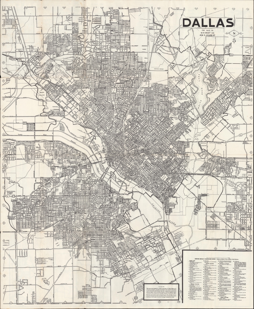
A large and detailed folding map of Dallas, Texas, produced in 1953 by the Dallas Railway and Terminal Co. and published by M. H. West. Co. The map captures Dallas during its post-WWII economic boom.
The city did unusually well during the Great Depression thanks to the oil industry, setting it up for a robust postwar economic boom (the population of Dallas nearly tripled between 1940 and 1970). However, the streetcar network emphasized here was not a beneficiary of Dallas's economic growth and shut down in 1956.
A Closer Look
The booming metropolis of Dallas is displayed, with the public transportation network highlighted. A table at the bottom-right notes the streetcar, trolley coach, and motor coach lines. Streets, highways (many later reclassified as interstates), parks, cemeteries, waterways, railways, and other features are labeled throughout. Fair Park, site of the 1936 Texas Centennial Exposition, and the Cotton Bowl, appear near center. An alphanumeric grid surrounds the map, corresponding to an index on the verso. The verso also includes two insets of areas unable to fit on the recto, including the vicinity of Hensley Field. Several other airports appear, including Love Field, Mustang Airport, White Rock Airport, Redbird Airport (now Dallas Executive Airport), and Hudson Airport. Some were short-lived facilities established during World War II, while others are still in use. The aerospace industry was one of several that contributed to Dallas' rapid expansion in the mid-20th century, along with oil, finance, and electronics/computing.The city did unusually well during the Great Depression thanks to the oil industry, setting it up for a robust postwar economic boom (the population of Dallas nearly tripled between 1940 and 1970). However, the streetcar network emphasized here was not a beneficiary of Dallas's economic growth and shut down in 1956.
Publication History and Census
This map was prepared in 1953 by the Dallas Railway and Terminal Co. and published by M. H. West. Co. It is noted at three locations in the OCLC: Stanford University, Yale University, and the University of Wisconsin-Milwaukee.Cartographer
M. H. West (fl. c. 1910 - 1980) was a cartographer, landscape architect, map printer, and purveyor of surveying supplies based on Akard St. in downtown Dallas, Texas. Little biographical information is available about him, though he appears to have begun his career as a landscape architect and city planner in Illinois and Nebraska in the 1910s, before relocating to Dallas around the end of that decade, whereupon he began to produce maps. Dallas city directories of the era list him variously as a landscape architect and seller of engineers' supplies. Contemporary advertisements note him as selling blueprints, drawing and surveying supplies, maps, and charts. The firm appears in city directories as late as 1979, most likely outliving its founder. More by this mapmaker...
Condition
Fair. Wear along original folds. Light soiling. Verso repairs to fold separations and at fold intersections. Areas of loss at several fold intersections.
References
OCLC 767835874.